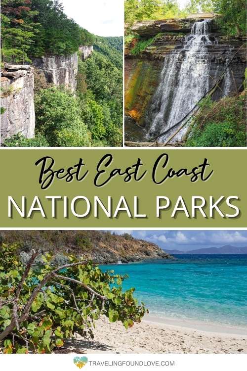
16 Best East Coast National Parks You Need to Visit
The east coast National Parks showcase some of the most beautiful and unique natural wonders of the country. Along the shoreline, you can find everything from mystic, deep forests, to snow powdered mountain peaks, the world’s longest cave system, and pristine white sand beaches.
For us, the United States is one of the most fascinating countries in the world with its huge variety of landscapes and outdoor adventures. That’s why we made it our goal to visit all of the U.S. National Parks. So far we made it to 43 of them, and some of our favorites are the National Parks in eastern U.S.
Let us inspire you with all the 16 National Parks’ best features and top things to do to figure out where your next National Park trip will take you. Don’t forget to read our best east coast National Parks road trip routes to make the most out of your trip.
This post may contain affiliate links. If you make a purchase through them, we get a small commission at no extra cost to you. It helps us create free content for you to enjoy. Learn more about our disclaimer here. Thanks for your support!
Get the America the Beautiful Pass
When visiting a lot of the eastern U.S. National Parks, the America the Beautiful Pass is the best purchase we can think of. It will save you big bucks.
For only $80 it gives you unlimited access to all of the more than 2,000 National Park sites for one whole year, the breathtaking east coast national parks and west coast national parks included. Too good to be true?! Check out our detailed post about the America the Beautiful pass to get to know all the perks.
Where is the “East Coast” in the U.S?

Technically the “east coast” refers to the states along the eastern Atlantic coastline. However, there are a few states that are considered east coast states even though they do not lie along the eastern shore.
There are 14 states which sit along the east coast with shorelines on the Atlantic Ocean and 1 U.S. territory. Here is a list of these states from north to south:
- Maine
- New Hampshire
- Massachusetts
- Rhode Island
- Connecticut
- New York
- New Jersey
- Delaware
- Maryland
- Virginia
- North Carolina
- South Carolina
- Georgia
- Florida
- U.S. Virgin Islands
There are 3 other states that are considered east coast states because of historical and geographical reasons.
- Vermont
- Pennsylvania
- West Virginia
How Many East Coast National Parks are there?
In our post, we have included the 16 best east coast National Parks. However, out of those 16, only 9 are located in actual east coast states.
So why did we cheat a little?
Since there are very few National Parks on the east coast compared to National Parks on the west coast, we expanded our coverage a little to not withhold the following 7 beautiful parks. They are assigned as eastern U.S. National Parks.
- Hot Springs National Park – Arkansas
- Mammoth Cave National Park – Kentucky
- Cuyahoga Valley National Park – Ohio
- Isle Royale National Park – Michigan
- Voyageurs National Park – Minnesota
- Indiana Dunes National Park – Indiana
- Gateway Arch National Park – Missouri
Top Tip: Even though there are not a lot of designated National Parks in the east, you can find hundreds of National Park Service sites in that area. Check out the complete list of the NPS sites in the United States you can choose to visit including National Monuments, National Seashores, and National Historic Sites.
Best East Coast National Parks
The official east coast National Parks are organized from the north, beginning with Acadia National Park, to the south, the Virgin Island National Park.
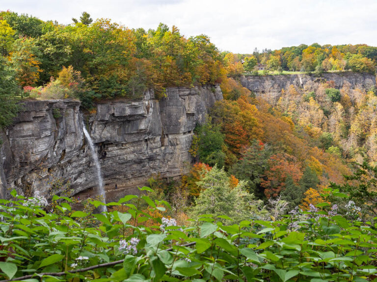
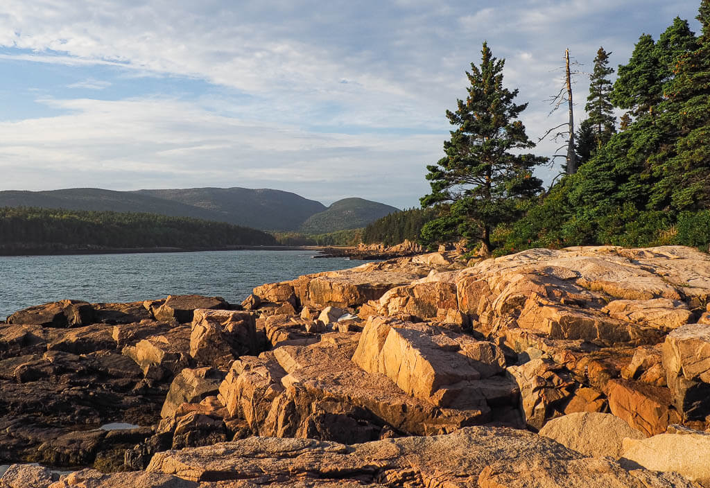
Acadia National Park
Location: Maine
Suggested Stay: 3-4 days
Entrance Fee: $30 per vehicle (valid for 7 days)
Closest Airport: Bangor International Airport (BGR), Portland International (PWM), Hancock County-Bar Harbor Airport (BHB)
Highlights: Cadillac Mountain, Park Loop Road, Sand Beach, Jordan Bond, Precipice Trail, Beehive Trail
Acadia National Park Official Website
Acadia National Park is one of the most dramatic National Parks on the east coast. You can’t help but fall in love with the charm of the New England landscape, dominated by rough coastlines, beautiful beaches, and pristine forests.
The National Park protects 47,000 acres of land which is mainly situated on Mount Desert Island. As one of the most visited National Parks in the United States, it is best described as a jungle gym for outdoor enthusiasts and a serene getaway for travelers.
Fun Fact: Acadia National Park is the oldest National Park east of the Mississippi River.
Top Tip: From May 25 through October 22, you will need to get a permit to drive to the top of Cadillac Mountain to either enjoy the sunrise or the spectacular views during the daytime.
Best Things to Do
1. Watch the Sunrise on top of Cadillac Mountain
Half the year, from October to March, you can be part of a very unique moment. Drive up to the top of Cadillac Mountain, the highest point in the park, and be one of the first people who watch the sunrise in the USA.
As you can guess, this is a very popular park attraction, which means you need to rise and shine very early to get a spot. With limited parking at the top of Cadillac Mountain, you will need to plan to arrive 1-2 hours before sunrise.
Note: From May to October you need to get a permit to drive up Cadillac Mountain.
2. Drive the 27 mile Park Road Loop
Park Road is the main road in Acadia National Park and the go-to scenic drive. Taking a ride along the 27 miles will bring you to all the major sites within the park. The drive can take a few hours or an entire day depending on your stops.
When planning your trip to Acadia National Park, keep in mind that one section of the Park Road is one way. However, there are a few enter and exit points.
The most important part about driving the Park Road is to drive slowly and carefully by abiding by all speed limits and watching out for pedestrians, bicycles, and wildlife.
Top Tip: To learn more about one of the most beautiful National Parks in eastern U.S. and find the best photo stops download a self-guided driving tour of Acadia for a small fee or book a narrated bus tour.
3. Hike the Precipice and Beehive Trail
These 2 Acadia hiking trails are the most challenging trails in the park due to sections of exposed vertical climb and walks along narrow ledges. On portions of the trails, you need to use metal rings bolted into the cliff to assist you on your climb.
By no means should you attempt these trails in poor weather conditions or when you are afraid of heights.
Precipice Trail Statistics:
Difficulty: Strenuous and challenging
Length: 2.5 miles
Time: 2 to 3 hours
Type of Hike: Loop
Elevation: over 1,000 feet
Location: Park Loop Road
Trailhead: Precipice Trailhead
When to Hike: Due to trail closure, there is only a short time frame when you can do this hike. From March into the summer, the trail is closed due to the peregrine falcon nesting season. During the winter, the harsh snow and ice conditions make it unsafe to hike the trail. The best time to experience the Precipice Trail is from late summer to fall, right before the snowfalls.
Beehive Trail Statistics:
Difficulty: Strenuous
Length: 1.5 miles
Time: 1 to 2 hours
Type of Hike: Loop
Elevation: 450 feet
Location: Park Loop Road
Trailhead: Beehive Trailhead
When to Hike: Hiking the Beehive Trail is best in good weather, usually in the spring, summer, and fall. In the winter, the trail is unsafe due to snow and ice.
4. Relax on Sand Beach
Sand Beach is a beautiful waterfront in Acadia National Park with eye-catching views of the Atlantic coast. The beach is set between picturesque granite mountains, and the rocky coastline, and a perfect location for a relaxing afternoon listening to the ocean.
This very popular attraction can be accessed from Park Loop Road. There is a good size parking lot which is almost always filled with cars. Here, you also have access to changing rooms and restrooms.
From the parking lot, take a look up at the mountain across the street and see if you can spot hikers climbing the Beehive Trail. Or head to the upper parking area, and take a leisure stroll on Ocean Path Trail. It is a very scenic paved pathway along the coast which leads to Thunder Hole and Otter Cliff.
5. Visit the Schoodic Peninsula
Schoodic Peninsula is the more secluded section of Acadia National Park. It is about an hour’s drive from the visitor center on Mount Desert Island.
You can explore the Schoodic Peninsula by the short scenic drive, biking, or hiking the trails. This part of the park is definitely way less traveled than Mount Desert Island.
What to Know Before Visiting Acadia National Park
- Get a vehicle registration permit to drive up Cadillac Mountain Road from May to October.
- Have patience. Getting around the park and enjoying the park’s highlights can take more time than anticipated due to the high volume of traffic.
- Utilize the FREE park shuttle service to get around the park.
- Acadia National Park is a dog-friendly park. Dogs are permitted on most of the trails as long as they are on a leash.
Acadia National Park Suggested Itinerary
DAY 1: Drive Park Loop Road, and visit Ocean Path with its two attractions Thunder Hole and Otter Cliff, Jordan Pond, and Bubble Rock
DAY 2: Enjoy the sunrise at Cadillac Mountain, hike Beehive or Precipice Trail (depending on when you are visiting), and relax at Sand Beach
DAY 3: Bike the Carriage Roads, and explore Bar Harbor in Maine
+DAYS: Get away from the crowds in the Schoodic Peninsula and Bass Harbor Head Lighthouse
When to Visit
If you are looking for the most convenient weather to explore Acadia National Park, then the best time to visit is from late spring to early fall.
In the end, visiting Acadia is great all year long. Each season brings something different, from warm weather for relaxing at the beach, to vibrant fall colors, and snowy mountain ranges.
Where to Stay
Camping – Blackwood Campground (NPS)
Budget – Gallagher’s Travels Bar Harbor Motel & Cabins
Midrange – Coach Stop Inn
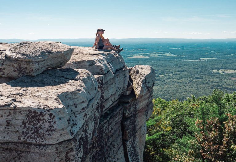
Shenandoah National Park

Location: Virginia
Suggested Stay: 2-3 days
Entrance Fee: $30 per vehicle (valid for 7 days)
Closest Airport: Dulles International Airport (IAD), Ronald Reagan Washington National Airport (DCA)
Highlights: Skyline Drive, Old Rag Mountain, Dark Hollow Falls, Hawksbill Mountain
Shenandoah National Park Official Website
Shenandoah National Park’s scenic views are perfect for National Park east coast lovers to escape into nature. You can choose to sit back and relax on the Skyline Drive, hike a few of the hundreds of miles of trails, chase glistening waterfalls, or gaze out into a field of wildflowers.
The National Park protects over 200,000 acres of land just 75 minutes south of Washington D.C.
Fun Fact: 101 miles of the Appalachian Trail are located within Shenandoah National Park.
Best Things to Do
1. Drive the 105 Skyline Drive
The 105-mile long Skyline Drive runs along the Blue Ridge Mountains from north to south. It is the only public road in the National Park. Plan about 3 hours to complete the entire drive.
Along the drive, there are 4 entrances into the park.
- Mile 0 – Front Royal Entrance Station by Route 66 and 340 – Front Royal, Virginia.
- Mile 31.5 – Thornton Gap Entrance Station by Route 211 near Luray, Virginia.
- Mile 65.5 – Swift Run Gap Entrance Station by Route 33 near Elkton, Virginia.
- Mile 104.6 – Rockfish Gap Entrance Station by Route 64 and Route 250 (Northern entrance to the Blue Ridge Parkway).
To help guide along the way, follow the mileposts. You will find them on the right side of the road if you are traveling south, and the left side if you are going north. Don’t forget to get out and enjoy the roughly 70 viewpoints along the way.
2. Hike Old Rag Mountain
Old Rag Mountain is one of the most popular hiking trails in the park. It is also the toughest and most rewarding hike. The trail presents some challenges with lots of switchbacks and rock scrambling. But in the end, it is all worth it. When you reach the top you will most definitely be rewarded with grand views of the mountains
Old Rag Mountain Trail Statistics:
Difficulty: Hard
Length: 9.5 miles
Time: 6-8 hours
Type of Hike: Loop
Elevation: just about 2,700 feet
Location: State Route 600
Trailhead: Old Rag Access Trail / Ridge Trail
When to Hike: All year round
3. See the Scenic Dark Hollow Falls
The cascading water of the Dark Hollow Falls attracts many visitors every year. Of the many waterfalls in Shenandoah, Dark Hollow Falls is one of the easiest accessible. It is located 0.7 miles off of Skyline Drive.
A short steep hike brings you right to the falls. The waterfall plunges about 70 feet over a course of 4 drops with the upper 2 drops being the most scenic.
Dark Hollow Falls Trail Statistics:
Difficulty: Moderate
Length: 1.4 miles
Time: 1-1.5 hours
Type of Hike: Out and Back
Elevation: 560 feet
Location: Skyline Drive
Trailhead: Dark Hollow Falls Trail
When to Hike: Spring is the best time to hike to waterfalls because of the runoff from the winter.
4. Reach the Summit of the Hawksbill
Hawksbill Mountain is the tallest mountain in Shenandoah National Park at 4,050 feet. It is the perfect place to catch a sunset with a clear 270-degree view overlooking the Linville Gorge.
The trail to the summit is short but steep and rocky, so take your time as you climb. When you reach the top you may even feel like you are on top of the world, which makes your efforts well worth it.
Hawksbill Mountain Trail Statistics:
Difficulty: Moderate
Length: 1.5 miles
Time: 1-1.5 hours
Type of Hike: Out and Back
Elevation: about 700 feet
Location: Skyline Drive
Trailhead: Lower Hawksbill Trail
When to Hike: Catch a sunset from the summit
5. Visit the Nearby Luray Caverns
Luray Caverns is one of the largest caves in the eastern United States. It is only an 18-minute drive from the Thorton Gap Entrance Station in Shenandoah National Park.
The caverns are open every day of the year. To visit, you will need to purchase a ticket. An admission ticket includes Luray Caverns, the Car & Carriage Caravan Museum, Toy Town Junction, and the Shenandoah Heritage Village.
A quick stop to Luray is worth it on your best National Parks on east coast journey.
What to Know Before Visiting Shenandoah National Park
- Obey the 35 mph speed limit while driving on the Skyline Drive and keep an eye out for wildlife. While we were coasting on the Skyline Drive a Mama Bear and her cubs crossed the road right in front of us.
- Purchase an Old Rag Mountain day-use permit in advance if visiting between March to November.
- Shenandoah National Park is home to the densest population of Black Bears in the United States. Be prepared by bringing some bear spray
- Shenandoah National Park is a dog-friendly park. Dogs are permitted on most of the trails as long as they are on a leash.
Shenandoah National Park Suggested Itinerary
DAY 1: Tour Skyline Drive and stop at the overlooks, hike Fox Hollow trail and/or Compton Peak, explore Luray and visit Luray Caverns
DAY 2: Hike Old Rag Mountain
DAY 3: Take the Hawksbill Mountain trail, find the Dark Hollow Falls, and revel more in the Skyline Drive
When to Visit
Shenandoah is a great National Park on the east coast to visit all year round.
If you are looking to see something special in the park we would recommend visiting in the fall or spring season. The fall turns Shenandoah into a sea of vibrant oranges, reds, and yellows due to the gorgeous fall foliage. The late spring brightens up Shenandoah with beautiful wildflowers.
Where to Stay
Camping – Big Meadows Campground (NPS)
Budget – Hampton Inn Front Royal
Midrange – TownePlace Suites by Marriott Front Royal
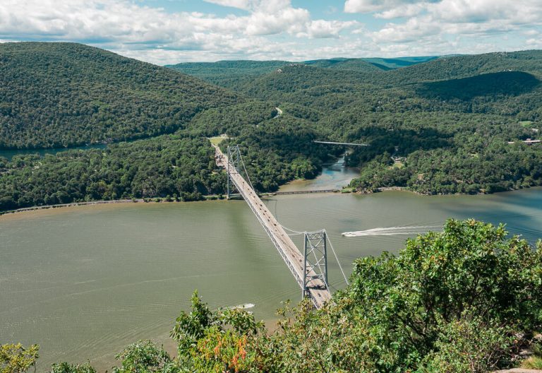
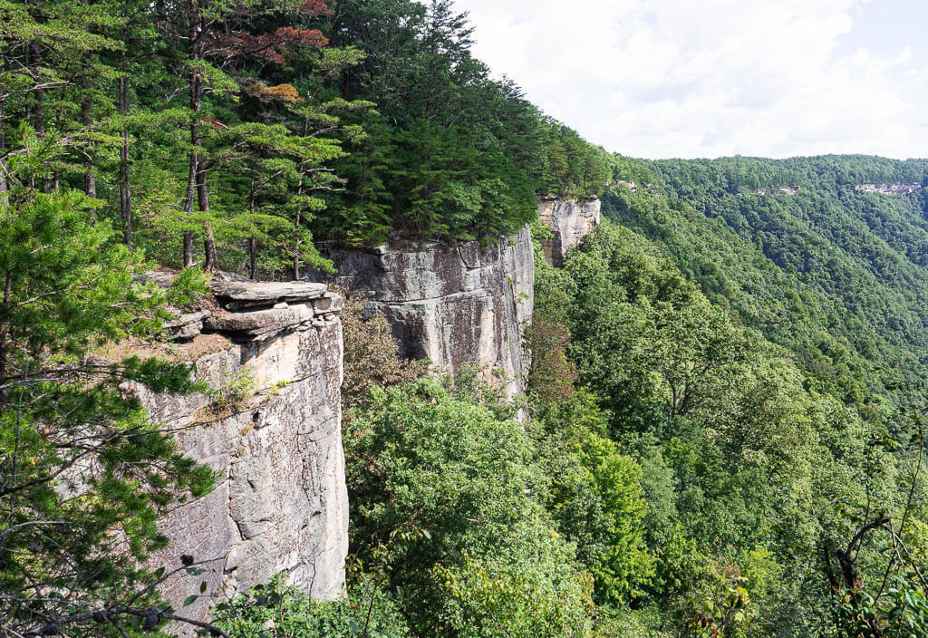
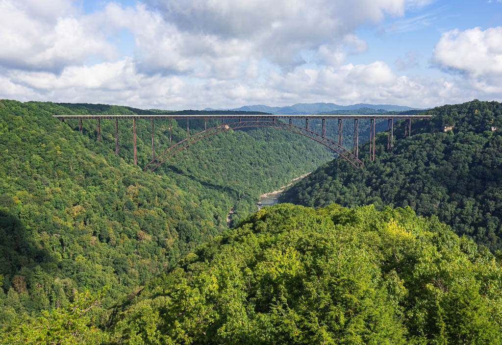
New River Gorge National Park
Location: West Virginia
Suggested Stay: 3-4 days
Entrance Fee: Free
Closest Airport: West Virginia International Yeager Airport (CRW), Roanoke–Blacksburg Regional Airport (ROA), Lynchburg Regional Airport (LYH)
Highlights: The New River, New River Gorge Bridge, whitewater rafting, hiking trails
New River Gorge National Park Official Website
Before officially becoming a National Park, the New River Gorge was recognized as a National River. When it was redesignated in 2020 it became one of America’s newest National Parks in the east.
The park is made up of 70,000 acres along the New River. The New River is a rugged whitewater river that flows northward in deep canyons. This park is definitely a rafters paradise.
Rafting is not the only thrilling adventure that is waiting for you in the New River Gorge National Park. This place is filled with exciting activities like the Bridge Walk, Base Jumping, and Climbing.
Fun Fact: The New River in New River Gorge National Park is the second oldest river on earth.
Best Things to Do
1. Whitewater Rafting
Going whitewater rafting on the New River or Gauley River is hands down the best thing to do in this National Park on the east coast. We completed our whitewater rafting trip with ACE Adventure Resort and absolutely loved it. They offer a wide range of tour options from half-day trips to full-day trips and even overnight adventures. For the optimal rafting experience, you will want to go from April to October.
If you are an experienced rafter or daredevil, you can take on the class I-V rapids of the Upper Gauley River for a few weeks in the fall.
2. New River Gorge Bridge
The construction of the New River Gorge Bridge drastically changed the accessibility of the area. Crossing the river once took almost an hour, now it can be done in a minute.
Besides snapping an artistic photo of the New River Bridge, take a daring walk across it. The Bridge Walk tour lets you hike the entire 3,030-foot length of the bridge on a 24-inch catwalk. To reserve your spot, make sure to book in advance.
3. Hike the Trails
New River Gorge National Park has a variety of hiking trails within the park. Here are a few of our favorites.
CANYON RIM BOARDWALK
The Canyon Rim Boardwalk trail provides a clear scenic view of the New River Gorge and bridge. It is an easily accessible trail with 2 overlooks. To reach the second overlook, you will descend 178 stairs for a closer look at the bridge.
Canyon Rim Boardwalk Statistics:
Difficulty: Easy
Length: 0.2 miles
Time: 10 minutes
Type of Hike: Out and Back
Elevation: less than 100 feet
Location: Canyon Rim Visitor Center
Trailhead: Canyon Rim Boardwalk
When to Hike: Anytime
ENDLESS WALL TRAIL
The Endless Wall trail has fantastic views of the New River Gorge as you walk zig-zag along the cliffs of the gorge. As you stand roughly 1,000 feet above the river, you can watch and listen to whitewater rafters below. Be sure to stop at viewpoints along the way, especially Diamond Point.
Endless Wall Trail Statistics:
Difficulty: Easy
Length: 2.4 miles
Time: 1-1.5 hours
Type of Hike: Point to Point
Elevation: just about 300 feet
Location: Lansing-Edmond Road
Trailhead: Endless Wall Trail
When to Hike: All year
LONG POINT TRAIL
The Long Point trail passes through fields and forests as you make your way to Long Point Overlook. Here, clear straight-on views of the New River Gorge Bridge are waiting for you.
Long Point Trail Statistics:
Difficulty: Moderate
Length: 3.0 miles
Time: 2 hours
Type of Hike: Out and Back
Elevation: just over 300 feet
Location: Parking lot off County Route 9
Trailhead: Long Point Trail
When to Hike: All year
CASTLE ROCK TRAIL
The Castle Rock Trail is a more challenging hike along massive rock wall cliffs. Instead of walking on the cliffs on the Grandview Rim Trail, the Castle Rock Trail brings you below the cliff overhangs. Be prepared for a lot of uneven, rocky surfaces with steep drop-offs.
Castle Rock Trail Statistics:
Difficulty: Difficult
Length: 1.0 mile
Time: 30 minutes – 1 hour
Type of Hike: Loop
Elevation: 150 feet
Location: Grandview Visitor Center
Trailhead: Castle Rock Trail and/or Grandview Rim Trail
When to Hike: best April through October
4. Thurmond Historic District
In the early 1900s, Thurmond was a bustling mining town with huge amounts of coal brought in by the nearby mines. The town had the largest revenue along the Chesapeake & Ohio Railway.
Today, Thurmond has been shockingly untouched by modern expansion. The National Park Service’s mission is to preserve the nation’s history in the town of Thurmond.
Take a quick trip to Thurmond Historic District on your trip to this east coast National Park and check out the train depot and old buildings along the railroad. You can learn all about the history of the area from the signs in front of the buildings.
What to Know Before Visiting New River Gorge National Park
- We highly recommend booking activities like the Bridge Walk and whitewater rafting in advance.
- Bridge Day takes place every year on the 3rd Saturday in October. On this day, the New River Gorge Bridge is only open for foot traffic. Besides strolling along the vendors on the bridge, you can participate in different thrilling activities like base jumping or rappelling.
- The New River Gorge National Park only offers primitive camping on a first come first serve basis.
- The New River is a powerful river with technical rapids ranging from Class I to IV.
New River Gorge National Park Suggested Itinerary
DAY 1: Do the Bridge Walk, and hike the Canyon Rim Boardwalk, the Endless Wall Trail, and Long Point Trail
DAY 2: Get wet on a Whitewater Rafting trip, and tour the Thurmond Historic District.
DAY 3: Get on the Grandview Rim, and Castle Rock Trail
+DAYS: You can’t get enough of thrilling outdoor adventures? Nelson Rocks are known as one of the top Via Ferrata trails in the USA. We can highly recommend booking your tour with NROCKS.
When to Visit
Technically, you can visit the New River Gorge National Park all year long. In our opinion, the best time to stop by is from April to October, especially if you are looking to go whitewater rafting.
Where to Stay
Camping – Grandview Sandbar Campground (NPS)
Budget – Sleep Inn Beaver – Beckley
Midrange – Tru by Hilton Beckley
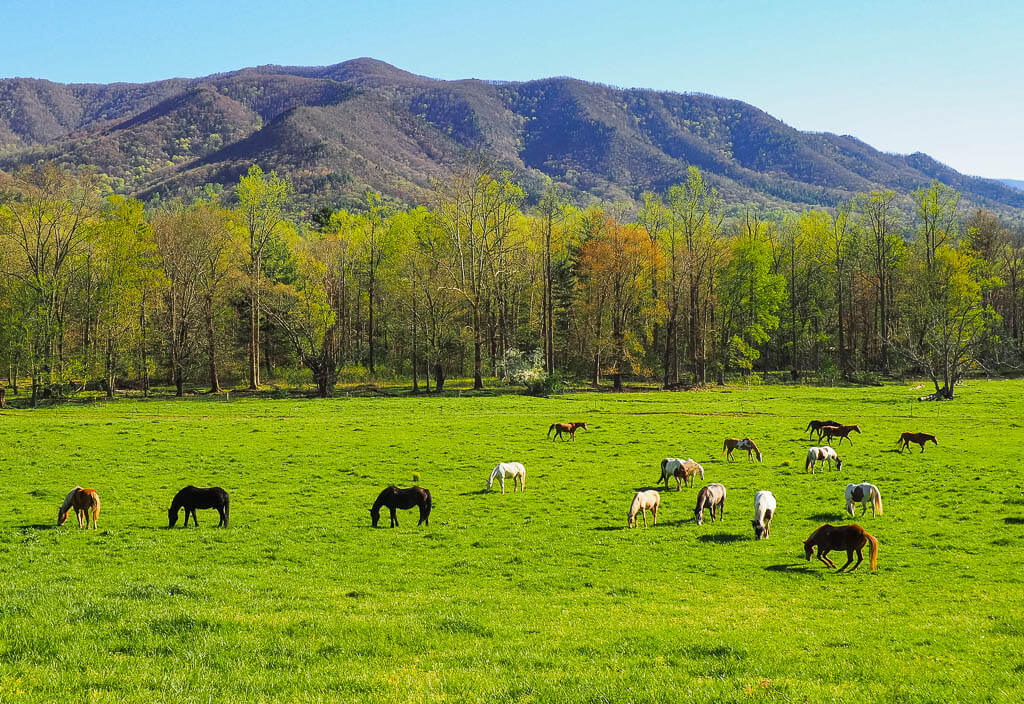
Great Smoky Mountains National Park
Location: North Carolina, Tennessee
Suggested Stay: 3-5 days
Entrance Fee: Free
Closest Airport: Knoxville McGee Tyson Airport (TYS), Gatlinburg Pigeon Forge Airport
Highlights: Clingman’s Dome, Cades Cove, Wildflowers, Waterfalls, Wildlife
Great Smoky Mountains National Park Official Website
Great Smoky Mountains National Park offers a wide range of activities for all ages, from hiking to biking, horseback riding, fishing, and much more.
The National Park protects over 500,000 acres of land between the borders of North Carolina and Tennessee.
It is referred to as the “Wildflower National Park” where you can find wildflowers of all kinds blooming in the dense forests from late winter to late fall.
Fun Fact: Great Smoky Mountains National Park is the most visited National Park in the United States.
Best Things to Do
1. Cades Cove Loop Road
Cades Cove Loop Road is an 11-mile one-way road through a lush valley surrounded by towering mountains. This scenic drive showcases historic buildings from churches, to log cabins, barns, and a mill. Make sure to be conscious of the 20 mph speed limit while you are auto touring.
2. Roaring Forks Motor Nature Trail
Roaring Forks Motor Nature Trail is a 5.5-mile one-way loop that allows you to explore a different side of the Smokies. Along the road, you will find old log cabins, grist mills, and other historic buildings.
3. Clingman’s Dome
Clingman’s Dome is the tallest point in the Great Smoky Mountains National Park at 6,643 feet. It is also the highest point in Tennessee. At the summit of Clingman’s Dome, there is an observation tower that provides 360-degree views of the Smoky Mountains and beyond. It is a steep half-mile walk to reach the observation point.
4. Chase Waterfalls
Waterfalls can be found in a lot of different spots throughout the Great Smoky Mountains National Park, ranging from large falls to small cascades. These are the most prominent ones:
- Abrams Falls is a small but powerful waterfall. At 20 feet high it is plunging into a deep pool. You can access Abrams Falls via the Abram Falls Trail in Cades Cove which is a 5-mile round trip hike.
- Grotto Falls is a picturesque 25-foot waterfall that can be accessed from the Trillium Gap Trail. The 3 miles round trip hike will lead you through an old-growth hemlock forest and even behind the waterfall.
- Laurel Falls is an 80-foot waterfall consisting of an upper and lower section. The falls can be accessed via the Laurel Falls Trail which is a 2.6-mile round trip hike. It is one of the most popular spots in the park, which is why parking is limited.
- Rainbow Falls is a spectacular 80-foot waterfall that occasionally showcases a visible rainbow. The falls can be accessed from the Rainbow Falls Trail, a difficult 5.4 miles round trip hike.
5. Alum Cave Trail
The trail leads hikers through a variety of terrain. After entering a hardwood forest, you will make your way through the narrow tunnel of Arch Rock, climb up Peregrine Peak, and pass Inspiration Point, until you finally reach the Alum Cave Bluffs. You do have the choice to continue to the summit of Mount LeConte.
Alum Cave Trail Statistics:
Difficulty: Moderate
Length: 4.4 miles
Time: 3 hours
Type of Hike: Out and Back
Elevation: just over 1,000 feet
Location: Newfound Gap Road
Trailhead: Alum Cave Trail
When to Hike: All year round, sunrise
6. Visit Gatlinburg, Tennessee
Gatlinburg is just a few miles outside of the Great Smoky Mountains National Park. A stopover in Gatlinburg is a must when visiting this best National Park on the east coast. With its unique shopping options, delicious eateries and restaurants, and fun outdoor activities it is not a surprise that it is a very popular tourist destination.
What to Know Before Visiting Great Smoky Mountains National Park
- Great Smoky Mountains National Park is home to the largest population of American Black Bears in the east. Be prepared and bring bear spray.
- Expect the park to be crowded when you visit due to it being the most visited National Park in the United States.
- Booking reservations for camping and lodging in advance is highly recommended.
Great Smoky Mountains National Park Suggested Itinerary
DAY 1: Drive the Newfound Gap Road, hike the Alum Cave Trail, make your way to Clingmans Dome
DAY 2: Drive Cades Cove Loop Road, explore Cades Cove area, hike to Abrams Falls
DAY 3: Hike the Roaring Forks Motor Nature Trail and explore Gatlinburg
+DAYS: Chase more waterfalls on the Rainbow Falls Trail, or Laurel Falls Trail, and visit the Tuckaleechee Caverns
When to Visit
Honestly, there is no bad time to visit the Great Smoky Mountains National Park on the east coast. It is beautiful all year long with each season bringing something new and special.
A lot of people love to visit this National Park on east coast in the fall to witness the spectacular fall foliage on the east coast.
Where to Stay
Camping – Smokemont Campground (NPS)
Budget – Brookside Resort by FairBridge
Midrange – Crossroads Inn & Suites
Congaree National Park
Location: South Carolina
Suggested Stay: 1-2 days
Entrance Fee: No entrance fee
Closest Airport: Columbia Metropolitan Airport (CAE), Charlotte Douglass International Airport (CLT)
Highlights: Boardwalk Loop Trail, Congaree River, Fireflies
Congaree National Park Official Website
Congaree National Park is part of the Congaree Biosphere Reserve. This National Park on east coast preserves the largest number of Southern bottomland hardwood trees in the United States.
The Congaree River runs through the park which causes flooding frequently. There are even times the park is covered in so much water the hiking trails are being washed out.
Congaree encompasses 26,276 acres of land in Central South Carolina about 18 miles southeast of Columbia, the state’s capital.
Fun Fact: Even though this park was once named Congaree Swamp National Monument, it is actually not a swamp. It is a floodplain, an area lying next to a river, which is only covered by water parts of the year, whereas a swamp is permanently covered with water.
Best Things to Do
1. Go Kayaking or Canoeing
Kayaking or Canoeing gives a unique experience to Congaree National Park. The Cedar Creek Canoe Trail is a 15-mile marked trail through Congaree which starts at Bannister’s Bridge.
If you plan on going kayaking or canoeing at Congaree, you will either need to bring your own gear or rent gear from a nearby outfitter.
No matter if you are an experienced paddler or a beginner, it is important to be mindful of the current river conditions and have the appropriate equipment with you.
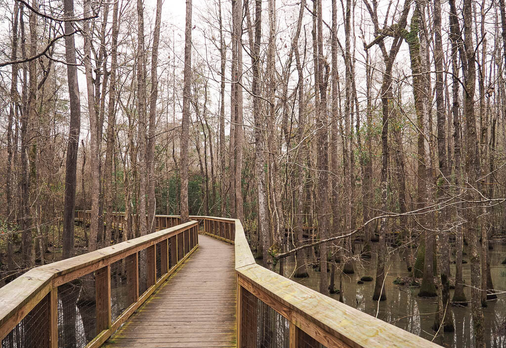
2. Boardwalk Loop Trail
The Boardwalk Loop Trail is the most popular and most used trail in Congaree National Park. This easy hike goes along an elevated wooden boardwalk through the swamp old-growth forest. On the trail, you will see gorgeous cypress trees, pine trees, and other flora, plus a variety of wildlife.
Boardwalk Loop Trail Statistics:
Difficulty: Easy
Length: 2.4 miles
Time: 1.5 hours
Type of Hike: Loop
Elevation: Very little
Location: Harry Hampton Visitor Center
Trailhead: Boardwalk Loop Trail
When to Hike: Anytime
3. Catch the Synchronous Fireflies
Each year for roughly 2 weeks from mid-May to mid-June, Congaree National Park hosts synchronous fireflies. Seeing the synchronous flashing of light while the fireflies search for a mate is a spectacular, rare event you can’t miss.
The park does limit the number of visitors. Try your luck and get tickets from the lottery system.
What to Know Before Visiting Congaree National Park
- Carry bug spray! The mosquitoes can be brutal during the warmer months.
- Congaree National Park only has 1 visitor center in the park which is where 99% of the trails are accessed from.
- Be aware of the water levels of Congaree River before heading out to go kayaking or canoeing.
Congaree National Park Suggested Itinerary
DAY 1: Walk the Boardwalk Loop Trail, Kayak on the Congaree River
+DAY: Hike the River Trail or other desired hiking trail
When to Visit
The best time to visit Congaree National Park is in the spring or fall when the temperatures are warm and the mosquitoes are quiet. The fall brings vibrant colors shining through Congaree, while the late spring night sky is lit up by the synchronous fireflies.
Do keep in mind that Congaree sees a few inches of rain every month which can impact your National Park visit.
Where to Stay
Camping – Longleaf Campground (NPS)
Budget – Courtyard by Marriott Columbia Cayce
Midrange – Home2 Suites by Hilton Columbia Southeast Fort Jackson
Everglades National Park
Location: Florida
Suggested Stay: 1-3 days
Entrance Fee: $30 per vehicle (valid for 7 days)
Closest Airport: Miami International Airport (MIA)
Highlights: Shark Valley, Airboat Rides, Birdwatching, Anhinga Trail
Everglades National Park Official Website
The Everglades offer a much different national park experience. The largest tropical wilderness in the U.S. invites you to explore abundant wildlife on stunning hiking and kayaking trails.
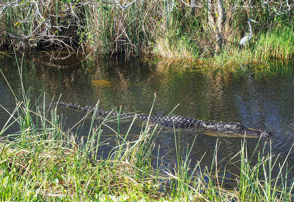
Everglades National Park protects 1.5 million acres of wetlands on the tip of southern Florida. The park is made up of mangroves and marshes which is home to a variety of endangered or rare species.
The most famous inhabitant is the alligator. Since there are 200,000 alligators living in the Everglades, you can be sure to encounter some of these fascinating animals.
The Everglades National Park is also recognized as a World Heritage Site and part of the International Biosphere Reserve.
Fun Fact: Did you know that the Everglades is the largest wetlands in the world?
Best Things to Do
1. Bike the Shark Valley Road
There are 5 biking trails within the Everglades National Park. The most popular is the Shark Valley Tram Road. It is a 15-mile easy paved path that can sometimes provide extremely close encounters with alligators and a variety of birds. The full route will take anywhere from 2 to 3 hours to complete.
Halfway into your ride, you will reach the Shark Valley Observation Tower. This is the highest accessible point within the entire Everglades.
You can either bring your own bicycles with you or rent bicycles from Shark Valley Tram Tours. Bicycles go quickly, so if you do not want to wait, make sure to get to the shop when they open. Otherwise, you go on a waiting list and have to wait until people return them.
If you don’t want to bike the Shark Valley Road, you can also walk it or take a tour on a tram.
2. Hike the Trails
The Everglades has a variety of hiking trails in the park’s different sections which allow you to explore the diverse landscape.
ANHINGA TRAIL
The Anhinga Trail is one of the most popular hiking trails due to the insane amount of wildlife that can be spotted on the trail. You can expect to see alligators, anhingas, turtles, herons, and a variety of birds. It is a short easy trail through a sawgrass marsh.
Anhinga Trail Statistics:
Difficulty: Easy
Length: 0.8 miles
Time: 30 minutes
Type of Hike: Loop
Elevation: None
Location: Royal Palm Parking Lot
Trailhead: Anhinga Trailhead
When to Hike: All year round, best in fall, winter, and spring
MAHOGANY HAMMOCK TRAIL
The Mahogany Hammock Trail is a boardwalk trail that winds through a dense jungle-like landscape with a variety of plants. On the trail, you will see the largest living mahogany tree in the United States.
Mahogany Hammock Trail Statistics:
Difficulty: Easy
Length: 0.4 miles
Time: 20 minutes
Type of Hike: Loop
Elevation: None
Location: Mahogany Hammock Road
Trailhead: Mahogany Hammock Trail
When to Hike: All year round, best in fall, winter, and spring
PA-HAY-OKEE TRAIL
The Pa-hay-okee trail provides great views from its elevated platform loop.
Pa-hay-okee Trail Statistics:
Difficulty: Easy
Length: 0.2 miles
Time: 15 minutes
Type of Hike: Loop
Elevation: None
Location: Pa-hay-okee Road
Trailhead: Pa-hay-okee Trail
When to Hike: All year round, best in fall, winter, and spring
3. Take an Airboat Ride
Cruising around in an Airboat is very unique to Everglades National Park and a pretty cool experience.
If you plan on booking an airboat ride, keep in mind there are only 3 authorized companies that offer tours within the National Park. You can find all of them on US Highway 41 between Miami and Shark Valley. Make sure to book a tour with these companies:
4. Paddling Trails
The Everglades provide numerous paddling opportunities to explore the marsh, mangroves, ten thousand islands, and waters of Florida Bay. It is your choice if you want to paddle for a few hours, make it a day-long adventure, or even a multi-day trip on the water. Make sure to plan ahead for this expedition.
Paddling trails can be accessed at the Flamingo Marina, Gulf Coast Visitor Center, and along the roads that approach these areas.
Flamingo Paddling Trails:
- Nine Mile Pond
- Noble Hammock
- Hell’s Bay
- Florida Bay
- Bear Lake
- Mud Lake Loop
- West Lake
Gulf Coast Paddling Trails:
- Sandfly Island Loop
- Turner River
- Halfway Creek
Top Tip: Don’t have your own gear? No worries, you are in luck. You can rent equipment in the Flamingo and Gulf Coast areas.
What to Know Before Visiting Everglades National Park
- There are only 3 authorized Airboat companies that offer airboat tours within Everglades National Park. (Coopertown Airboats, Gator Park, Everglades Safari Park)
- The 3 main entrances to the Everglades National Parks are hours from one another. Make sure to know which entrance to drive to before starting your trip.
Everglades National Park Suggested Itinerary
DAY 1: Explore the Gulf Coast of Everglades National Park and cruise around the Ten Thousand Islands
DAY 2: Bike Shark Valley, enjoy an airboat ride
DAY 3: Hike the Pa-hay-okee, the Mahogany Hammock, and the Nine Mile Pond trail
When to Visit
If you didn’t already know, Florida is not the most pleasant place to visit in the summertime due to the heat. The Everglades is no different. The summer’s unbearable heat also brings pesky mosquitoes.
That is why we would not recommend visiting this east coast park in the summer. Instead, travel there from December to March. During this time the weather is beautiful and the mosquitos are low. Most of the park’s activities and best features are at their peak during the winter season.
Where to Stay
Camping – Flamingo Campground
Budget – Hilton Garden Inn Homestead
Midrange – Comfort Suites Miami – Kendall
Biscayne National Park
Location: Florida
Suggested Stay: 1-2 days
Entrance Fee: Free
Closest Airport: Miami International Airport (MIA)
Highlights: Maritime Heritage Trail, Boca Chita Key, Elliot Key, Stiltsville
Biscayne National Park Official Website
If you are a water lover, then Biscayne is one of the best National Parks on east coast. The park’s biggest attraction is the world’s third-largest coral reef system which is home to an array of colorful inhabitants, shipwrecks, and wildlife. Although most of the park is underwater, there are a series of islands within the park.
Fun Fact: 95% of Biscayne National Park is underwater.
Best Things to Do
1. Elliot Key
Elliot Key is the largest island in Biscayne. It was once a thriving community, but today most people visit Elliot Key for its camping opportunities, to stroll around the island, or enjoy water activities.
2. Boca Chita Key
You can’t miss Boca Chita Key on your trip to Biscayne since it is the most visited key in the park. As you approach Boca Chita Key you will be welcomed by the iconic lighthouse that was built in the 1930s.
While visiting the key, you can visit the lighthouse observation deck if there is a park ranger around, walk the short hiking trail, have a picnic, and enjoy the beach.
3. Stroll the Convoy Point Jetty Trail
The Jetty Trail at Convoy Point is an easy and short trail along the mangrove shores to the Colonial Bird Protection Area.
Point Jetty Trail Statistics:
Difficulty: Easy
Length: 0.8 miles
Time: 15 – 20 minutes
Type of Hike: Out and Back
Elevation: 0 feet
Location: Dante Fascell Visitor Center
Trailhead: Jetty Trail
When to Hike: All year round
4. Kayak in Jones Lagoon
Get out on the water and explore this east coast park by kayaking in Jones Lagoon. Here you have a good chance of seeing stingrays, jellyfish, schools of fish, and a variety of birds wading in the water.
5. Go Snorkeling on the Maritime Heritage Trail
The Maritime Heritage Trail is one of the most popular attractions in Biscayne National Park. Along the trail, you can explore the remains of various shipwrecks ranging in size and year they sank.
Here are the 6 wrecks along the trail:
- Arratoon Apcar – Sank 1878
- Fowey Rocks Lighthouse – Built 1878
- Erl King – Sank 1891
- Alicia – Sank 1905
- Lugano – Sank 1913
- Mandalay – Sank 1966
6. Guided Boat Tour
Since the park is basically only reachable by boat, you can take a pick at a variety of boat tours offered in the National Park. There are only 6 companies that are authorized to provide tours within the park, so make sure you are booking through one of the approved parties.
What to Know Before Visiting Biscayne National Park
- A visit to Biscayne National Park requires some advance planning, especially if you want to join a tour.
- The best way to enjoy the park is by being out in the water, since 95% of the park is actually in the water.
- Arrive early in the day to snag a parking spot at the Visitor Center.
- Make sure to have bug spray with you, mosquitoes can be quite annoying.
Biscayne National Park Suggested Itinerary
DAY 1: Take a guided tour which includes an island visit, kayaking Jones Lagoon, and snorkel on the Maritime Heritage Trail, visit Dante Fascell Visitor Center and Stroll the Convoy Point Jetty Trail
+DAY: Visit another island on a guided boat tour
When to Visit
The best time to visit the best east coast National Parks in Florida is from mid-December to April. This is the driest time of the year for the semi-tropical climate, providing optimal weather to enjoy Biscayne National Park adventures.
From June to November, the temperature in Florida is extremely hot and humid.
Where to Stay
Camping – Larry and Penny Thompson Memorial Park and Campground
Budget – Hilton Garden Inn Homestead
Midrange – TownePlace Suites by Marriott Miami Homestead
Dry Tortugas National Park
Location: Florida
Suggested Stay: 1-2 days
Entrance Fee: $15 per vehicle (valid for 7 days) + costs to get to the island
Closest Airport: Miami International Airport (MIA), Key West International Airport (EYW)
Highlights: Fort Jefferson, water activities – snorkeling, scuba diving, kayaking
Dry Tortugas National Park Official Website
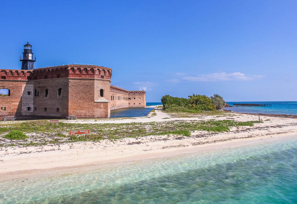
Dry Tortugas National Park sits at a remote island 70 miles west of Key West. The park encompasses about 100 square miles of open water and 7 small islands.
The most common and cheapest way to get to this eastern U.S. National Park is by ferry. You can choose if you want to stay there for a day or overnight.
If you choose the day trip, you will have 4.5 hours to explore the island and the pristine waters before you journey back to the mainland.
When you prefer to stay overnight on the primitive campground, you will get a very unique island experience. You will only have to share the peninsula with a handful of other people after the ferry makes its way back to Key West.
Fun Fact: Dry Tortugas National Park is 100 square miles big but only 1% is land.
Best Things to Do
1. Visit Fort Jefferson
Fort Jefferson is Dry Tortuga’s biggest attraction. This large coastal fortress was built in the 1800s to protect ship traffic in the Gulf of Mexico and Florida. Ironically, the fort was never finished and never attacked. But it is still a strong symbol of U.S. history.
You can choose to tour the fort on your own or with a guided ranger-led tour.
2. Snorkeling at Garden Key
Garden Key is the second-largest island at Dry Tortugas at 14 acres and home to Fort Jefferson. The best thing to do while visiting Garden Key is to explore underwater. One of the key sites to snorkel is around the moat wall.
3. Walk along Bush Key
Exploring Bush Key is a unique experience at Dry Tortugas National Park. It is a 16 acre remote, undeveloped, subtropical island that can only be accessed from late fall to early winter.
Due to the unique landscape of the island, you can either enter it via a land bridge from Garden Key or by kayak/canoe. When the key is open, visitors can walk the 1 mile out and back shoreline trail.
What to Know Before Visiting Dry Tortugas National Park
- The park is only accessible by seaplane, ferry, or private charter boat.
- Boating permits are required for private boaters. The permits are free though.
- Since the park is located in a hard to reach area, it is vital to plan ahead. It is best to get tickets for the ferry weeks prior to your trip.
- If you want to camp overnight, reserve your tickets 9-12 months in advance to secure your spot.
Dry Tortugas National Park Suggested Itinerary
DAY 1: Join a ranger-led tour to explore Fort Jefferson, and go snorkeling at Garden Key
+DAYS: Relax at the dream beaches and walk around Bush Key
When to Visit
You will want to visit Dry Tortugas National Park on the east coast between June and September for the calmest waters and best visibility while snorkeling.
Bush Key is open from October through January. If this picturesque island is on your bucket list, plan your visit accordingly.
Where to Stay
Camping – Dry Tortugas Campground (NPS)
Budget – Seashell Motel & Key West Hostel
Midrange – Tropical Inn
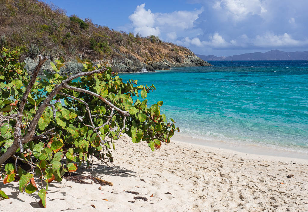
Virgin Island National Park
Location: St. John, U.S. Virgin Island
Suggested Stay: 2-3 days
Entrance Fee: Free
Closest Airport: St. Thomas Cyril E. King Airport (STT)
Highlights: Trunk Bay, sea turtles, sea life, white sand beaches, clear blue waters
Virgin Island National Park Official Website
A trip to Virgin Island National Park is the perfect mix of a relaxing beach vacation in paradise and fascinating outdoor experiences. The park is located on the U.S. Virgin Island of St. John, in the Caribbean ocean, close to Puerto Rico. To get there, you have to fly to St. Thomas, the bigger and more touristy neighbor island of St. John.
This park is one of the National Parks in the eastern U.S. which is best known for its underwater snorkeling trails. Make your way along reefs and corals, and encounter sea turtles, sharks, and other marine life. But not just the underwater trails are gorgeous. Make sure, you also hike some of the jungle treks on land, explore ancient ruins and petroglyphs, and gaze out at amazing views.
Fun Fact: More than half of the land on the island of St. John lies within the park boundaries.
Best Things to Do:
1. Hike the Trails
The Virgin Island National Park has very unique hiking trails with beautiful vistas. Here are some of the best trails to hike.
CANEEL HILL TRAIL
Hike up Caneel Hill to see out above it all. From the top, you have fantastic views of the bays and beaches below on the Northside of the island. Be aware that the trail is steep and might be slippery after a rain shower.
Caneel Hill Trail Statistics:
Difficulty: Moderate
Length: 4.0 miles
Time: 2-3 hours
Type of Hike: Out and Back
Elevation: 1,700 feet
Location: Off of Centerline Road, Cruz Bay
Trailhead: Caneel Hill Trail
When to Hike: Go in the morning or for sunset
REEF BAY TRAIL
On the Reef Bay Trail, you will hike past the tallest and oldest trees on the island, old sugar plantations, rock carvings, and other remnants of the past. Be prepared for steep, uneven, rocky, slippery ground.
Reef Bay Trail Statistics:
Difficulty: Moderate
Length: 4.4 miles
Time: 2-4 hours
Type of Hike: Out and Back
Elevation: 1,200 feet
Location: Off of Centerline Road
Trailhead: Reef Bay Trail
When to Hike: Start in the morning
LIND POINT TRAIL to HONEYMOON BEACH
The Lind Point Trail is a partially shaded tree-lined trail along the coast. It is a mostly flat and sandy trail that leads to the beautiful Honeymoon Beach.
Lind Point Trail Statistics:
Difficulty: Easy
Length: 2.3 miles
Time: 1 hour
Type of Hike: Loop
Elevation: Just over 300 feet
Location: Park Center Road, Cruz Bay
Trailhead: Lind Point Trail
When to Hike: Hike in the morning and enjoy a day at Honeymoon Beach
RAM HEAD TRAIL
Ram Head Trail is a narrow trail that leads hikers up to the top of Ram Head. The climb may be a little difficult but the views will be worth it.
Ram Head Trail Statistics:
Difficulty: Moderate
Length: 2.3 miles
Time: 1.5 hours
Type of Hike: Out and Back
Elevation: 315 feet
Location: Virgin Island Route 107
Trailhead: Salt Pond Bay Trail to Ram Head Trail
When to Hike: Get out in the morning
2. Snorkel the Underwater Trail at Trunk Bay
The Underwater Trail at Trunk Bay helps snorkelers discover the beauty of the eastern Caribbean Sea. Along the trail, you can read signs which provide insight into the colorful reef and marine life. The trail follows the west side of Trunk Bay Cay for about 300 feet before turning back to the beach. Be cautious to venture out past the trail, as the waters become much rougher.
3. Waterlemon Cay
Take the Leinster Bay Trail to Waterlemon Cay which is about a 20-minute walk from the Annaberg Ruins parking area. This area is particularly popular because of the high chances to encounter some small nurse sharks in the water.
You can choose to snorkel near the main Leinster Bay or venture out towards Waterlemon Cay. If you do so, it is suggested to stay on the southern side due to a strong current on the north side. When entering the water be careful not to get hurt on the sharp rocks and spiky sea urchins. It is best to wear fins or another kind of footwear.
4. Visit the Annaberg Plantation Ruins
The Annaberg Plantation Ruins are some of the best-preserved ruins on the Virgin Islands. It was the largest sugar mill on the island and when in use it produced sugar, rum, and molasses.
To reach the ruins you will have to take about a 20-minute drive from Cruz Bay on St. John. Once there, you can explore the ruins on foot. You will see the reminisce of the sugar mill, slave quarters, and more. There are information signs you can read along the way to learn more about the plantation.
5. Relax on Honeymoon Beach
Spend a relaxing day at Honeymoon Beach and enjoy the white sand beaches and clear blue waters of the Virgin Islands with good Caribbean food and a drink in your hand. If you feel like being more active, rent kayaks, stand-up paddleboards, and other equipment to have a fun-filled day in this east coast National Park.
What to Know Before Visiting Virgin Islands National Park
- Getting to the Virgin Islands National Park requires some planning. You will have to take a ferry from the main island to arrive in paradise.
- If you want to explore the National Park more independently, renting a car is by far your best bet. Don’t rely on the public bus system or the taxis.
- Don’t get us wrong, Honeymoon Beach is beautiful but it is one of the most popular beaches for day tourists. If you can only visit one of the beautiful beaches visit Trunk Bay for the real National Park feeling.
- The sun is extremely powerful in the Caribbean. Make sure to protect your skin properly, especially when you go snorkeling. We were wearing swim shirts and used a lot of sun screen to avoid sun burns.
Virgin Island National Park Suggested Itinerary
DAY 1: Arrive at Cruz Bay, hike the Lind Point Trail to Honeymoon Beach, relax on the beach
DAY 2: Explore the Ram Head Trail and/or Reef Bay Trail, snorkel the Underwater Trail at Trunk Bay, view the sunset at The Windmill Bar
DAY 3: Drive out to the Annaberg Plantation Ruins, hike Leinster Bay Trail to Waterlemon Cay, snorkel out by the Cay to see some sharks
Top Tip: If you are staying at St. Thomas and you just visit St. John for a day, consider taking a guided kayaking, hiking, and snorkeling tour to experience the best this east coast National Park has to offer.
When to Visit
The best time to plan a visit to the Virgin Island National Park is from December to June. You can expect milder temperatures, less rainfall, and even a breezy night.
Summer is also a popular time to visit the islands, however, it is usually packed with tourists and very hot. Towards the end of summer and into the fall is usually hurricane season, so you should avoid traveling during this time of the year.
Where to Stay
Camping – Cinnamon Bay Beach and Campground
Budget – Inn at Tamarind Court
Midrange – Marketplace Suites
Bonus: Eastern U.S. National Parks
Even though the following parks are technically not located on the east coast, they are assigned as eastern U.S. National Parks. We couldn’t help it but had to mention them in this post because we don’t want you to miss out on them.
Cuyahoga Valley National Park
Location: Ohio
Suggested Stay: 1-2 days
Entrance Fee: Free
Closest Airport: Cleveland Hopkins International Airport (CLE)
Highlights: Virginia Kendall Hedges hike, Brandywine Falls, Cuyahoga Valley Scenic Railway, Towpath Trail
Cuyahoga Valley National Park Official Website
Cuyahoga Valley National Park is situated between the urban areas of Cleveland, Ohio, and Akron, Ohio. Since it sits between 2 urban cities, it includes a heavy road network and small towns.
It is the only National Park in the state of Ohio and encompasses more than 33,000 acres along the Cuyahoga River.
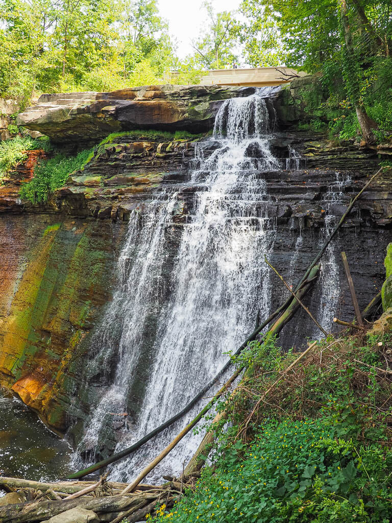
Fun Fact: Brandywine Falls in Cuyahoga Valley National Park is Ohio’s tallest waterfall.
Best Things to Do
1. Cuyahoga Valley Scenic Railway
Taking the train to explore a National Park on east coast is something completely different, you can’t miss. Instead of getting your feet tired, sit back and relax on this 3.5-hour scenic ride.
It is your choice if you want to take on the ride during the day to spot the abundant wildlife or if you want to join one of the various Dinner & Event train rides, like Murder Mystery, Cocktails on Rails, or Trivia on the Train.
2. Towpath Trail
The Towpath Trail is part of the old Ohio and Erie Canalway. The trail is open 24 hours a day for walkers, bikers, or runners who want to experience a part of history.
You can enter the 87 miles of trail on multiple access points. However, only 20 miles of the Towpath Trail lay within the park boundaries.
3. Brandywine Falls
Brandywine Falls is one of the most popular attractions in the park. The 60-foot waterfall can be accessed via a boardwalk. There is an upper deck and lower deck for viewing the falls. The upper deck gives you a birds-eye view, while the lower deck gets you a closer look at the rushing waters of Brandywine Falls.
If you are looking to extend your experience around Brandywine Falls, think about hiking the Brandywine Gorge Trail.
4. The Ledges Trail
The Ledges Trail wraps around a plateau of stunning rock formations with extensive views overlooking the valley. For most of the trail, you will follow along towering moss-covered walls, known as the Ledges.
The Ledges Trail Statistics:
Difficulty: Moderate
Length: 2.6 miles
Time: 1-2 hour
Type of Hike: Loop
Elevation: about 200 feet
Location: Truxell Road in the Virginia Kendall State Park Historic District
Trailhead: The Ledges Trail
When to Hike: All year round
5. Spot Wildlife at Beaver Marsh
Beaver Marsh is full of life. A walk on the marshland boardwalk provides visitors the opportunity to explore the marsh for wildlife.
Depending on when you visit will determine what wildlife you may encounter in the marsh. It is the most diverse area of Cuyahoga Valley National Park.
What to Know Before Visiting Cuyahoga Valley National Park
- One of the nicest things about Cuyahoga Valley National Park is you won’t find entrance gates, long lines, or permit requirements. It is a very accessible National Park on the east coast.
- Upon arrival, check out the Boston Mill Visitor Center to get to know the latest information and the best events.
Cuyahoga Valley National Park Suggested Itinerary
DAY 1: Ride the Cuyahoga Valley Scenic Railway, admire Brandywine Falls, hike the Ledges trail, and spot wildlife at Beaver Marsh.
+DAYS: Hike parts of the Towpath Trail and visit the less explored areas of Cuyahoga Valley National Park.
When to Visit
No matter when you visit Cuyahoga Valley, you will have a great experience. Our preferred times to visit this east coast national park area is in the spring and fall. During the spring the waterfalls will be roaring and in the fall the colors of the trees will be bright.
Where to Stay
Camping – Nimisila Reservoir Metro Park
Budget – Hampton Inn & Suites Oakwood Village-Cleveland
Midrange – Staybridge Suites Akron-Stow-Cuyahoga Falls, an IHG Hotel
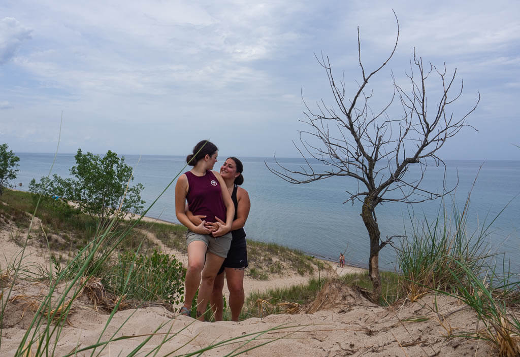
Indiana Dunes National Park
Location: Indiana
Suggested Stay: 1-2 days
Entrance Fee: Free
Closest Airport: Chicago Midway International Airport (MDW)
Highlights: Dune Succession Trail, Mount Baldy, 3 Dune Challenge, Lake Michigan
Indiana Dunes National Park Official Website
Indiana Dunes National Park is one of America’s newest east National Parks. The park covers a 15 mile stretch along the coast of Lake Michigan for a total of 15,000 acres.
This National Park in east coast is like no other. You can walk up glacial sand which has over time created mountainous dunes, swim and paddle in a great lake, and hike through a diverse ecosystem.
Fun Fact: Indiana Dunes is Indiana’s first official U.S. National Park.
Best Things to Do
1. 3 Dune Challenge – Indiana Dunes State Park
Completing the 3 Dune Challenge is a popular attraction. However, it is actually located in the Indiana Dunes State Park instead of the Indiana Dunes National Park.
This challenging climb tackles the 3 tallest dunes in the state park on a 1.5-mile trail with an incline of 552 feet vertical through the loose sand.
2. Dune Succession Trail
The Dune Succession Trail is in the West Beach area of the park. The loop showcases the development of dunes, beginning at the beach shore to a boardwalk that rises above the sand through the forest.
Dune Succession Trail Statistics:
Difficulty: Easy
Length: 1.1 miles
Time: 30 minutes
Type of Hike: Loop
Elevation: Just about 100 feet
Location: West Beach Road
Trailhead: Dune Succession Trail
When to Hike: April to October
3. Mount Baldy Trail
Mount Baldy is the largest dune in Indiana Dunes National Park. Each year it moves about 4 feet, covering anything in its path.
You can’t actually take the short steep sandy climb to the summit on your own, you have to join a ranger-led tour. If you plan on doing this hike, make sure to check the hike dates and times on the park’s website.
Mount Baldy Trail Statistics:
Difficulty: Easy
Length: 0.9 miles
Time: 30 minutes
Type of Hike: Out and Back
Elevation: Just under 100 feet
Location: U.S. Highway 12
Trailhead: Mount Baldy / Fire Trail
When to Hike: All hikes to the summit must be led by authorized rangers.
4. Visit Historical Sites + Century of Progress Homes
Besides preserving the magnificent landscape of the park, Indiana Dunes National Park also preserves parts of our nation’s history. Here are some of the sites you have to visit on your trip:
Historical Landmarks in Indiana Dunes National Park
- Bailly Homestead
- Chellberg Farm
- Good Fellow Youth Camp
1933 World’s Fair Century of Progress Homes
- Armco-Ferro House
- Cypress Log Cabin
- Florida Tropical House
- House of Tomorrow
- Wieboldt-Rostone House
5. Relax along the Beach of Lake Michigan
Within the National Park, there are 15 miles of sandy beaches along the southern shores of Lake Michigan to enjoy. There are numerous parking lots for the beaches which are open from 6:00 AM to 11:00 PM providing running water and restrooms. Parking usually fills up quickly during the warmer months. So if you are looking to enjoy a full day on the beach, get there early.
Here are the beaches in Indiana Dunes National Park
- West Beach – (has a small fee to park and lifeguards)
- Portage Lakefront and Riverwalk Beach
- Porter Beach
- Kemil Beach
- Dunbar Beach
- Lake View Beach
- Central Avenue Beach
- Mount Baldy Beach
What to Know Before Visiting Indiana Dunes National Park
- Indiana Dunes National Park is free to visit, however, Indiana Dunes State Park has a $7 fee for Indiana plates and a $12 fee for out-of-state plates.
- The National Park is less than 40 miles from Chicago, Illinois.
- Weather can make or break your experience at Indiana Dunes National Park. The summer brings heat which is extremely tough when you are exposed while hiking on the unshaded dunes, and sometimes (heavy) winds which makes relaxing at the beach almost impossible
Indiana Dunes National Park Suggested Itinerary
DAY 1: Tackle the 3 Dunes Challenge, hike the Dune Succession Trail and Mount Baldy, educate yourself in the Century of Progress Homes, and finish the day with a beach sunset
DAY 2: Visit more historical sites, and relax on a beach
When to Visit
Technically, you can visit Indiana Dunes National Park on the east coast all year round. However, we would be inclined to recommend exploring the park during the warmer parts of the year like spring, summer, and fall.
Summers are perfect for catching rays at the beach along the shores of Lake Michigan, while spring is great for hiking the dunes and admiring wildflowers, and fall is awesome for the fall foliage.
Where to Stay
Camping – Dunewood Campground (NPS)
Budget – Waterbird Lakeside Inn
Midrange – Hilton Garden Inn Chesterton
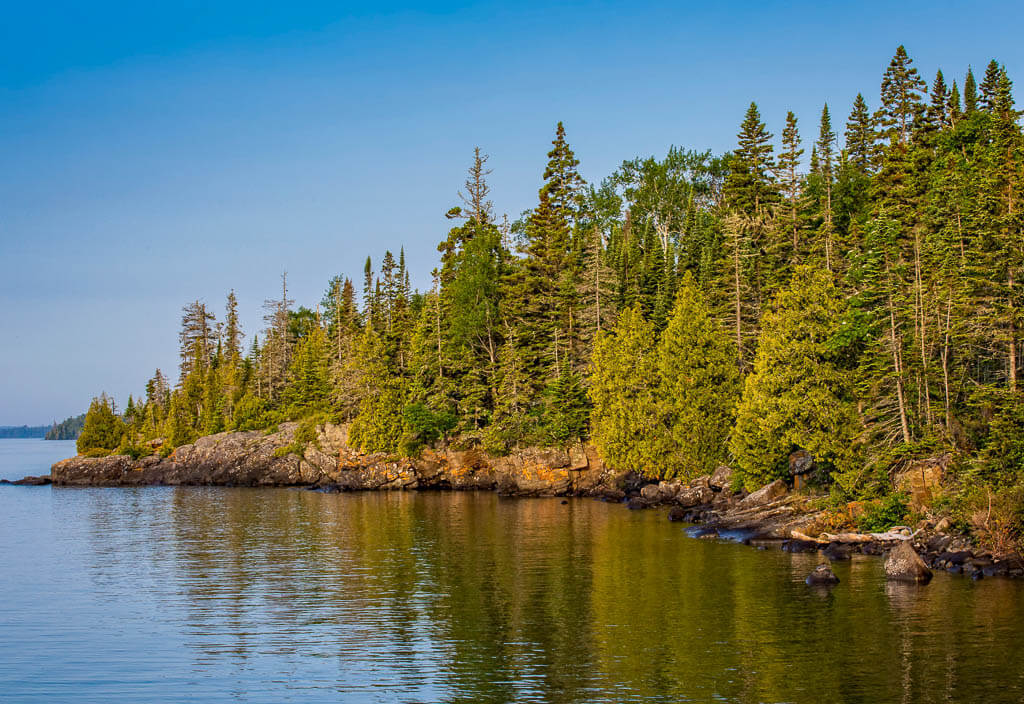
Isle Royale National Park
Location: Michigan
Suggested Stay: 3-5 days
Entrance Fee: $7 per person daily entrance fee
Closest Airport: Thunder Bay International Airport (IATA: YQT) in the Canadian province of Ontario, Minneapolis−Saint Paul International Airport (MSP)
Highlights: Lake Superior, wilderness, wildlife
Isle Royale National Park Official Website
This National Park is a rugged remote island in the state of Michigan. It is a backpacker’s and an adventurer’s dream destination as it gets you far away from the hustle and bustle of civilization.
The rugged island sits in Lake Superior with open wilderness free from cars. The entire island is 45 miles long and 9 miles wide. It provides an abundance of wildlife, nature, and scenic views.
To get there, you have to take a ferry, seaplane, or private charter. Unfortunately, transportation to this isolated peninsula is a little pricey and you really have to inform yourself about your transportation options.
Fun Fact: Isle Royale is one of the least visited National Parks in the east and even in the United States.
Best Things to Do
1. Hiking the Trails
Isle Royale National Park east coast is full of hiking trails. Hitting some of them is the best way to explore the island.
STOLL MEMORIAL TRAIL _ SCOVILLE POINT
Before you finally make it up to Scoville Point, you will hike through forests and on a rock exposed trail on Rock Harbor.
Stoll Trail Statistics:
Difficulty: Moderate
Length: 4.7 miles
Time: 2-2.5 hours
Type of Hike: Loop
Elevation: Just under 200 feet
Location: Rock Harbor Visitor Center
Trailhead: Stoll Trail
When to Hike: When the park is open.
SUZY’S CAVE
Take the Tobin Harbor Trail to Suzy’s Cave, an inland sea arch that was formed over 4,000 years ago when the water level of the lake was much higher.
Suzy’s Cave Trail Statistics:
Difficulty: Moderate
Length: 4.3 miles
Time: 2 hours
Type of Hike: Out and Back
Elevation: around 250 feet
Location: Rock Harbor Visitor Center
Trailhead: Tobin Harbor Trail
When to Hike: When the park is open
2. Go Kayaking, Canoeing, and Fishing
Going kayaking, canoeing, and fishing are the top things to do when visiting Isle Royale National Park. If you plan on bringing your own kayak or canoe, make sure you read up on the requirements and how to transport your equipment. You can also rent equipment in Rock Harbor and Windigo.
3. Lighthouse of Isle Royale National Park
Isle Royale Lighthouse – Located on Menagerie Island, on Isle Royale south shore.
Rock Harbor Lighthouse – Oldest lighthouse in the park, located on the southwest entrance of Rock Harbor.
Passage Island Lighthouse – Located on the northeast side of the park
Rock of Ages Lighthouse – Tallest lighthouse in the park, you can view the lighthouse from Windigo Visitor Center.
What to Know Before Visiting Isle Royale National Park
- There is no access to the park in winter. The park is closed from October 31 through April 15.
- If you want to be on a ferry heading to Isle Royale National Park, make sure to book ferries well in advance.
- There are no vehicles allowed on the island.
- Be prepared with everything you need since you will be entering a remote area of the United States.
Isle Royale National Park Suggested Itinerary
DAY 1: Take the ferry over to Rock Harbor on Isle Royale National Park, and hike the Stoll Memorial Trail to Scoville Point
DAY 2: Hike to Suzy’s Cave, and take a water taxi to the Rock Harbor Lighthouse or a nearby island
+DAYS: Backpack from the campground to campground, book a sightseeing tour with the Rock Harbor Lodge, go fishing, or explore the island on the waters by paddling in a kayak or riding a boat
When to Visit
You can’t visit Isle Royale National Park all year long. From October 31 to April 15 the park is closed. The busiest season is from mid-July to mid-September.
Where to Stay
Camping – Moskey Basin
Budget – Windigo Camper Cabins
Midrange – Rock Harbor Lodge
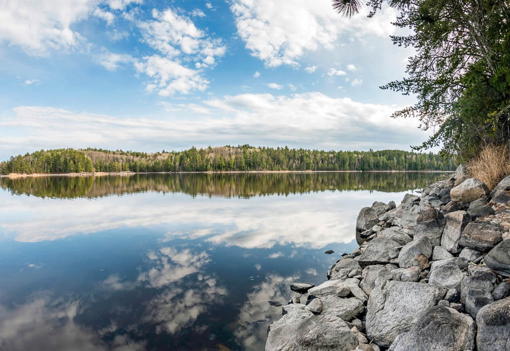
Voyageurs National Park
Location: Minnesota
Suggested Stay: 1-3 days
Entrance Fee: Free
Highlights: Lake Kabetogama, Ellsworth Rock Garden, Kettle Falls Hotel, Little American Island
Closest Airport: Falls International Airport (INL), Minneapolis−Saint Paul International Airport (MSP)
Voyageurs National Park Official Website
Voyageurs National Park is a stunning east coast park for water enthusiasts. A total of ⅓ of the park is covered in water, so you can imagine that exploring the 30 lakes and countless islands is best on the waterways.
You can take advantage of the several guided boat tours the National Park offers, plan a family vacation in a houseboat, or explore the waters in the most traditional way with a canoe.
That’s how the French-Canadian Voyageurs traveled this area more than 400 years ago for trading purposes. They actually gave the Park its name.
Just make sure you also check out the mainland and islands for 100 miles of trails and stunning wildlife encounters with loons, eagles, foxes, deer, and even wolves.
Fun Fact: You may be able to view the Northern Lights from Voyageurs National Park
Best Things to Do
1. Gaze at the Northern Lights
We don’t want to get your hopes up too high but sporadically you are able to see the Northern Lights in Voyageurs National Park. Technically they could occur all year long but your best bet is to visit the park in the wintertime. Then it is dark out and our eyes are more likely to see the beautiful charged particles.
2. Drive to Lake Kabetogama
The Visitor Center at Lake Kabetogama is the perfect start for your National Park east coast adventure. You will get access to most of the park’s main attractions from over here. You can book a guided boat tour to Ellsworth Rock Garden, the Kettle Falls Hotel, or other popular islands.
Note: The Visitor Center is only open from late May to late September.
3. Visit Ellsworth Rock Garden
This outcrop on the north shore of Lake Kabetogama offers a beautiful garden with flowering plants, especially lilies. The special feature is the 200 stone sculptures which make the garden very artsy.
4. Lunch or Stay at the Kettle Falls Hotel
The Kettle Falls Hotel is still an operating hotel and restaurant, found in the National Register of Historic Places. You can enjoy the fascinating historic site on a day trip or get a special experience and stay overnight in this remote accommodation.
5. Go Fishing
If you are into fishing, the national park on the east coast might be your new favorite place. The best time for fishing is in late May and June. Then you get the chance to fish for northern pike, largemouth bass, whitefish, walleye, and many more. Ice fishing is very popular too but you have to expect harsh weather conditions.
6. Canoe your way around
Canoeing is the best way to see wildlife like turtles and birds. Since paddling is very quiet and peaceful, you get the chance to get close up to the animals in and around the waters.
You can bring your own canoe or you can rent one at the three Visitor Centers (Rainy Lake, Ash River, and Kabetogama Lake).
What to Know Before Visiting Voyageurs National Park
- The park is best accessible by boat. You can drive to the main visitor centers with your car but to fully appreciate the National Park’s beauty you will have to explore the waterways.
- All of the 161 reservable campsites are only accessible by watercraft. It is up to you if you prefer frontcountry or backcountry campsites. Build your own itinerary to best explore the park’s gorgeous nature.
- Make sure to book tickets for guided boat tours in advance. Especially during summer break they tend to sell out.
- No matter what your travel plans are, it is a good idea to bring a dry bag to protect your valuables from getting wet.
Voyageurs National Park Suggested Itinerary
DAY 1: Start your day at the Lake Kabetogama Visitor Center, take a guided boat tour to Ellsworth Rock Garden, drive the scenic route to Ash River Visitor Center, hike the short Beaver Pond Overlook and Blind Ash Trail
DAY 2: Take another boat tour from Rainy Lake Visitor Center to get to Little American Island to learn about the history of gold mining, or explore the historic Kettle Falls Hotel
+DAYS: Create your own itinerary to explore the waterways in Voyageurs National Park
When to Visit
If you want to take advantage of the park’s guided boat tours and ranger programs, you have to visit during the summer months, from late May to late September. This time also provides the best temperatures for your Voyageurs National Park adventure.
Expect this to be the busiest time with a lot of families going camping in the beautiful nature of this east coast park. In the early summer, the bugs will be at their peak, so be prepared.
Where to Stay
Camping – Woodenfrog Campground
Note: This campground is not part of the National Park Service. To camp within Voyageurs, we would recommend creating an itinerary for this National Park in east coast and then find campsites in the areas you want to stay in.
Budget – Days Inn by Wyndham International Falls
Midrange – Cantilever Hotel, Trademark Collection by Wyndham
Mammoth Cave National Park
Location: Kentucky
Suggested Stay: 1-2 days
Entrance Fee: Free
Closest Airport: Louisville International Airport (SDF), Nashville International Airport (BNA)
Highlights: Cave tours, hiking trails
Mammoth Cave National Park Official Website
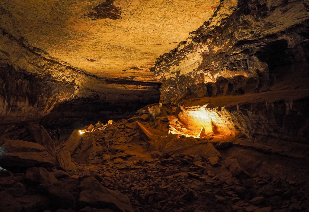
Mammoth Cave belongs to the most stunning National Park in the east for showcasing the world’s longest cave system. More than 400 miles are already mapped, and around 600 miles of underground corridors still remain undiscovered.
The park preserves the cave system, part of the Green River Valley, and a section of the rolling hills of south-central Kentucky. Besides being a National Park on the east coast since 1941, it is also a designated World Heritage Site (1981) and an International Biosphere Reserve (1990).
Although the main attractions are the cave tours offered, there are also plenty of other activities to do in Mammoth Cave National Park like exploring nature on the hiking trails, camping, kayaking, and horseback riding.
Fun Fact: Mammoth Cave National Park is the largest known cave system in the world.
Best Things to Do
1. Book a Cave Tour
Mammoth Cave National Park offers a variety of cave tours that are suitable for all types of adventures. Tours range from fully accessible wheelchair excursions to adventurous crawling trips and everything else in between. Booking a cave tour is an essential part of visiting Mammoth Cave National Park and is highly recommended.
However, it is best to book tours in advance so you do not miss out on your favorite one. Do keep in mind the tour schedule, dates, and times do change with the seasons.
For a more in-depth description of each tour, reservations, and need-to-know information, visit the park’s website.
2. Hiking the Trails
Although Mammoth Cave does not offer tons of hiking trails like other National Parks on the east coast, they do have 18 miles of trails to enjoy. There are around 7 miles of trails accessible from the visitor center area and 11 miles of hiking trails accessible from the south side.
HERITAGE TRAIL
The Heritage trail is an easy, very accessible boardwalk trail starting from the Visitor Center. It provides amazing views of the Green River and is an excellent sunset viewing point.
Heritage Trail Statistics:
Difficulty: Easy
Length: 0.5 miles
Time: 15 minutes
Type of Hike: Loop
Elevation: Very little
Location: Mammoth Cave Visitor Center
Trailhead: Heritage Trail
When to Hike: Anytime
SINKHOLE TRAIL
The Sinkhole trail of course showcases a sinkhole named the Mammoth Dome Sink. It is a large sinkhole that is actually the roof of the cave.
Sinkhole Trail Statistics:
Difficulty: Easy
Length: 2.0 mile
Time: 30 minutes
Type of Hike: Out and Back
Elevation: about 350 feet
Location: Mammoth Cave Visitor Center
Trailhead: Heritage Trail/ Echo River Springs Trail
When to Hike: Anytime
RIVER STYX SPRING TRAIL
The River Styx Spring trail is a very easy and short trail to a spring where water emerges from an underground cave.
River Styx Spring Trail Statistics:
Difficulty: Easy
Length: 0.4
Time: 15 minutes
Type of Hike: Out and Back
Elevation: About 250 feet
Location: Mammoth Cave Visitor Center
Trailhead: River Styx Spring Trail
When to Hike: Anytime during good weather
What to Know Before Visiting Mammoth Cave National Park
- We highly suggest making reservations for cave tours in advance because they often sell out. You do not want to miss out on this experience.
- Make sure to dress in layers for the cave tours. The temperature in the cave is usually around 54 degrees Fahrenheit.
- Familiarize yourself with the items you can’t bring into the cave.
Mammoth Cave National Park Suggested Itinerary
DAY 1: Explore the cave on a tour, and hike your desired trails
+DAYS: Book an additional cave tour or enjoy some water activities on the Green and Nolin Rivers
When to Visit
A visit to Mammoth Cave National Park on the east coast is great all year round. It will really depend on which adventure you are looking for.
The warmer months bring more crowds, but there are more tours available, and you will have beautiful weather to enjoy the outdoor trails. The colder winter months bring way fewer crowds with fewer tours offered.
Where to Stay
Camping – Mammoth Cave Campground (NPS)
Budget – Sleep Inn & Suites
Midrange – Hampton Inn Cave City, KY
Gateway Arch National Park

Location: Missouri
Suggested Stay: 1 day
Entrance Fee: $3.00 for visitors 16 and up
Closest Airport: St. Louis Lambert International Airport (STL)
Highlights: Gateway Arch, St Louis, Mississippi River
Gateway Arch National Park Official Website
Gateway Arch National Park is a different type of National Park on the east coast. Usually, when you think of National Parks you think of remote diverse landscapes, wildlife, and hiking trails. But that is not what to expect from Gateway Arch National Park.
This east coast park is located right in the heart of the city of St. Louis along the Mississippi River. The park represents St. Louis’s role in westward expansion in the United States. It is the smallest National Park in the United States.
Fun Fact: The most important feature of the park, Gateway Arch, is the tallest National Monument in the United States.
Best Things to Do
1. Tram Ride to the Top of Gateway Arch
Experience a different perspective of Gateway Arch as you take the 630 feet ride to the top of the arch. Tram rides usually last between 45-60 minutes. At the top, you will have sweeping views stretching out to 30 miles to the east and west.
Find out more about purchasing a tram ride ticket.
2. The Museum under the Arch
The museum under the arch provides detailed information about the westward expansion in the U.S. It is made up of 6 different galleries which deal with St. Louis’s role in the expansion. Start your museum journey with Colonial St. Louis and go in chronological order.
3. Tour Old Courthouse
Explore St. Louis and American history in the Old St. Louis Courthouse. It is known for its pivotal role in dealing with Dred Scott and Virginia Minor. You can tour the building to learn more about the historical events and see the restored courtrooms.
4. Stroll the Walking Trails along The Mississippi River
Take a stroll on the paved walking trails outside the Arch along the Mississippi River. Only a small portion of the St. Louis Riverfront Trail runs through the National Park. Or just meander along the paved walking paths inside the park.
5. Explore St. Louis Area
Since Gateway Arch National Park is located right in St. Louis, it is a no-brainer to spend some time exploring the city. Here are some suggestions on what to see in St. Louis:
- Anheuser-Busch Brewery
- St Louis Zoo
- Cathedral Basilica of Saint Louis
- Forest Park
- Market Street
- Cahokia Mounds State Historic Site
What to Know Before Visiting Gateway Arch National Park
- You will need to find parking on your own for Gateway Arch National Park. Use a parking app to find your best options.
- When entering Gateway Arch you will have to go through a security check. Be aware of what you are allowed to bring inside.
- It is recommended to purchase tram rides tickets in advance especially during peak season because they sell out quickly.
- There is only 1 entrance to the Gateway Arch. To visit the arch, you must enter through the west entrance which faces Fourth Street and the Old Courthouse. To exit Gateway Arch, you will go through the legs of the arch.
Gateway Arch National Park Suggested Itinerary
DAY 1: View the documentary, explore the museum under the Arch, ride the tram to the top, enjoy the walking trails and gardens around the Mississippi River, check out the Old Courthouse, spend the evening in St. Louis.
+DAYS: Explore more St. Louis attractions and visit the St. Louis Zoo.
When to Visit
Anytime is good to visit Gateway Arch National Park. It is a much different National Park on the east coast since it is set in a city and some of the best features can be found inside.
Summer is usually the most popular time to visit, so if you are looking to avoid some crowds, experience the park in the shoulder seasons.
Where to Stay
Camping – St. Louis West/Historic Route 66 KOA
Budget – Benton Park Inn
Midrange – Angad Arts Hotel
Hot Springs National Park

Location: Arkansas
Suggested Stay: 1-3 days
Entrance Fee: Free
Closest Airport: Memorial Field Airport (HOT / KHOT), Memphis International Airport (MEM)
Highlights: Bathhouse Row, Open spring water
Hot Springs National Park Official Website
Hot Springs National Park is an extremely unique National Park on east coast. The park’s uniqueness has drawn visitors for years to experience the thermal hot springs, grand architecture, and surrounding nature.
Fun Fact: Hot Springs National Park is one of the few National Parks eastern U.S. that is located in a city.
Best Things to Do
1. Bathhouse Row
Bathhouse Row in Hot Springs National Park is home to 8 beautiful bathhouses which were constructed between 1892 to 1923. Take your time admiring the stunning architecture while walking along the street.
- Lamar Bathhouse – built 1923
- Buckstaff Bathhouse – built 1912
- Ozark Bathhouse – built 1922
- Quapaw Bathhouse – built 1922
- Fordyce Bathhouse – built 1914-1915
- Maurice Bathhouse – built 1912
- Hale Bathhouse – built 1892
- Superior Bathhouse – built 1916
The only running bathhouses are Buckstaff Bathhouse and Quapaw Bathhouse.
2. Take a Bath at Buckstaff Bathhouse
The Buckstaff Bathhouse is one of the operating bathhouses where visitors can still experience a traditional bath. It is also the only bathhouse to continuously operated since its opening in 1912. The services offered at the Buckstaff are bathing, massages, pedicures, and manicures.
3. Hot Spring Mountain Tower
Hot Springs Mountain Tower sits 216 feet above Hot Spring Mountain. From here you have extraordinary views of the east coast park and its surrounding area.
4. Visit the Natural Spring
You can visit the natural thermal spring in 2 places in the park. The Display Spring is located behind the Maurice Bathhouse, the Hot Water Cascade is located at Arlington Lawn. The water at these springs comes out of the ground at 147 degrees Fahrenheit.
5. Sunset Trail
Sunset Trail is the longest trail in Hot Springs National Park. The trail circles you through the inner edge of the park boundary reaching the most remote parts of the park. Since the trail is quite long, it is usually split into 3 sections, West Mountain (2.8 miles), Sugarloaf Mountain (2.6 miles), and Stonebridge Road (3.8 miles).
Sunset Trail Statistics:
Difficulty: Difficult
Length: 10 miles one-way linear trail or 13-mile loop
Time: 4 – 4.5 hours
Type of Hike: Loop
Elevation: about 2,200 feet
Location: Fountain Street
Trailhead: Sunset Trail
When to Hike: All year round
What to Know Before Visiting Hot Springs National Park
- There are no outdoor thermal hot spring soaking opportunities. You can only soak in springs at the Buckstaff and Quapaw.
- Hot Springs National Park is an urban park located in the heart of downtown Hot Springs, Arkansas.
- There is metered parking and free parking downtown Hot Springs.
Hot Springs National Park Suggested Itinerary
DAY 1: Bath at the Buckstaff, walk the Promenade, go see Hot Water Cascade & Display Spring, and climb up the Hot Springs Mountain Tower
DAY 2: Hike the Sunset Trail
When to Visit
The optimal time to visit Hot Springs National Park is during the warmer months from July to October. During that time you can fully enjoy the outdoor activities this National Park on the east coast has to offer.
Where to Stay
Camping – Gulpha Gorge Campground (NPS)
Budget – Microtel Inn & Suites by Wyndham Hot Springs
Midrange – The Waters Hot Springs, Tapestry Collection by Hilton
Helpful Travel Planning Tools
Travel Insurance: Feel safe on all your adventures around the world with simple and flexible travel insurance for all occasions. l World Nomad
Rental Car: Explore breathtaking landscapes on the endless road with your rental car to get a taste of unlimited freedom! l Rentalcars
Accommodation: After a day full of adventures, you deserve a good night’s rest. Hotels.com offers cozy accommodations which will make you feel at home. l Hotels.com
Experiences: Make unforgettable experiences on your next trip with Get Your Guide, the best company to compare and book activities, and fun tours. l Get Your Guide
Suggested East Coast National Parks Road Trip Itineraries
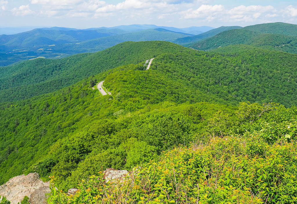
There is no doubt, visiting all the National Parks on the east coast is one of the greatest things to do. We always get so excited when we arrive at a new park, ready to explore the stunning nature and breathtaking hiking trails.
Even though all of the National Parks we mentioned are located on the east coast or in the eastern U.S., you shouldn’t underestimate the distances in between. From the most northern point in Maine to the most southern point in Florida, you will pass 14 states on 2,165 miles of coastline.
And then you would still have to add the parks which are located more towards the inland on the U.S. mainland and the National Park on the Virgin Islands to see all of the best east coast National Parks in one road trip adventure.
It will be an unforgettable road trip to visit all the eastern U.S. National Parks at once, but you will have to have a lot of time.
For those who don’t have a couple of weeks to travel to the best National Parks on east coast, we created 5 smaller road trip route ideas to make the most of your trip.
Top Tip: If you need to rent a car to tour all the east coast national parks, we can highly recommend this car rental company for the best prices in the USA. I Rentalcars.com
1. East Coast National Parks Road Trip Route: Down the Coast
This is the classic route that combines all of the best National Parks east coast which are actually located on the east coast from the north to the south.
You will get to see a great variety of landscapes, from high mountain peaks to rushing rivers, massive swamps, and tropical white beaches.
- Acadia National Park: 3-4 days
- Shenandoah National Park: 2-3 days
- New River Gorge National Park: 3-4 days
- Great Smoky Mountains National Park: 3-7 days
- Congaree National Park: 1-2 days
- Biscayne National Park: 1-2 days
- Everglades National Park: 1-3 days
- Dry Tortugas National Park: 1-2 days
Total Time For This Road Trip: 22 – 30 Days
2. East Coast National Parks Road Trip Route: The Bonus East Coast National Parks
These are the 7 National Parks that made it on our best National Parks on east coast list even though they are not exactly located in an east coast state. Nevertheless, they are absolutely worth visiting.
Explore the world’s longest known cave system, relax in an old school bathhouse, admire the stunning architecture and escape from the hustle and bustle to some remote islands in the National Parks in the east coast loop.
- Cuyahoga Valley National Park: 1-2 days
- Mammoth Cave National Park: 1-2 Days
- Hot Springs National Park: 1-3 days
- Gateway Arch National Park: 1 day
- Indiana Dunes National Park: 1-2 days
- Voyageurs National Park: 1-3 days
- Isle Royale National Park: 3-5 days
Total Time For This Road Trip: 15 – 24 days
3. East Coast National Parks Road Trip Route: The Inner Circle
Travel to 8 east National Parks in 8 different states on this inner circle loop. You will hit some of the classic east coast National Parks as well as some of our bonus parks.
On your journey, you will be able to relax at the beach of Lake Michigan, see the spectacular glowing of the fireflies, get high up to some mountain tops, and sit back and discover a National Park on the east coast during a train ride.
- Indiana Dunes National Park: 1-2 days
- Gateway Arch National Park: 1 day
- Mammoth Cave National Park: 1-2 days
- Great Smoky Mountains National Park: 3-7 days
- New River Gorge National Park: 3-4 days
- Shenandoah National Park: 2-3 days
- Cuyahoga Valley National Park: 1-2 days
Total Time For This Road Trip: 20 – 30 days
4. East Coast National Parks Road Trip Route: Florida National Parks
When visiting Florida, you have to make sure to add all of the state’s National Parks to your itinerary. Biscayne National Park and Everglades National Park are in close proximity to each other, whereas you have to take a ferry or seaplane from the U.S. mainland to reach Dry Tortugas National Park.
Get ready to explore the crystal clear waters and tropical fish on a snorkeling tour, explore historic forts, take a boat ride through a world-famous swamp, and enjoy some alligator encounters.
- Biscayne National Park: 1-2 days
- Everglades National Park: 1-3 days
- Dry Tortugas National Park: 1-2 days
Total Time For This Road Trip: 6-10 days
Bonus: Fly to the Virgin Islands National Park
If you also want to visit Virgin Islands National Park, we would highly recommend flying to the Virgin Islands from Miami. This is the closest and most convenient airport to get to the beautiful Caribbean Island.
5. East Coast National Parks Road Trip Route: Fall Foliage
If you are a fall foliage lover like we are, then this National Park road trip is a must for you! It will lead you along some of the most popular fall foliage routes the USA has to offer.
Explore the vibrant colors of the leaves on spectacular hikes, get thrilled on some of the best white water rapids in the U.S., and hit some quaint, little towns to get the ultimate fall feeling.
- Shenandoah National Park: 2-3 days
- New River Gorge National Park: 3-4 days
- Great Smoky Mountains National Park: 3-7 days
Total Time For This Road Trip: 10-16 days
The National Park Service has more to offer than just the designated National Parks we talked about earlier. The USA includes a total of 423 National Park sites located in every state. Top Tip: Wondering what the difference between a National Park and a National historic site is? National Parks cover a greater area and are more complex than historic sites. On your National Parks on the east coast trip, make sure to also hit some of our favorite historic sites listed below: Who says that National Parks in the east coast has to be more stunning and scenic than State Parks? We actually saw a lot of State Parks which were more mind-blowing than some of the National Parks we visited. The biggest difference between them is the management. State Parks are managed by state governments whereas national parks are operated by the federal government. Judge yourself and add some of these state parks to your National Parks on the east coast itinerary.
Did you like this post? Subscribe to our newsletter and we’ll send you more unique travel tips, updates, and even FREE content!Additional East Coast National Park Service Sites
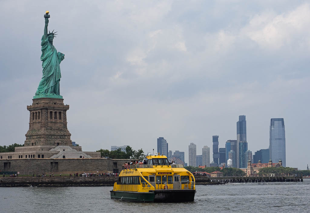
State Park Alternative to Visit
Which of the East Coast National Parks is your Favorite? Share Your Most Special National Park Memory with Us!
Our Other Resources for National Parks:
You Might Also Like
Save this Post for later on Pinterest!