33 Most Beautiful Trails for Hiking in Hudson Valley
As locals, we might be a little biased but hiking in Hudson Valley is simply out of this world. It is the best destination in New York for everyone to enjoy the outdoors, extraordinary landscapes, and fresh air. No matter if you want to climb one of the stunning mountains or just stroll around in the woods, we promise you will love your hiking in Hudson Valley experience.
In its various remarkable State Parks, Shwangunks, and the Catskill Mountains you will find hundreds of hikes with thousands of miles for all skill levels. Over the last years, we tackled a lot of them and couldn’t resist finally giving you a list of our favorite hiking trails with all the information you need to hike them.
Hopefully, it helps to make a decision on which trails you would like to hike a little easier! Happy hiking!
This post may contain affiliate links. If you make a purchase through them, we get a small commission at no extra cost to you. It helps us create free content for you to enjoy. Learn more about our disclaimer here. Thanks for your support!
Hudson Valley Regions
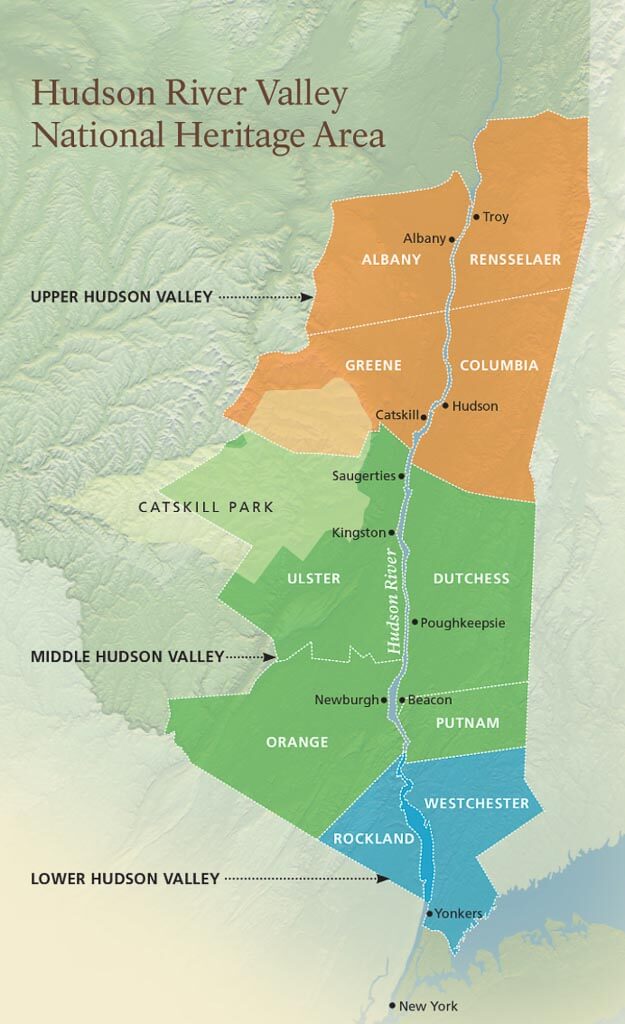
The Hudson Valley encompasses a wide area of New York State from just above New York City all the way up to the Capital District. The region includes all of the New York counties which sit along the Hudson River.
There are 3 different sections from the north to the south: Upper Hudson Valley, Mid Hudson Valley, and Lower Hudson Valley. Those sections can again be separated into the east side of the Hudson River and the west side of the river.
Where Can You Find the Best Hudson Valley Hikes?
The Hudson Valley has endless hiking trails scattered throughout the region but the majority of the best trails are located within the Mid Hudson Valley region on both sides of the Hudson River.
You will find these hiking trails in the Hudson Valley State Parks, such as Minnewaska State Park, Bear Mountain State Park, Harriman State Park, and Hudson Highlands State Park, as well as in the Shawangunk Mountains, and the Catskill Mountains.
How to Get to the Hudson Valley Hiking Trails
Within a roughly 3 hour or more drive from the north of the Hudson Valley area to the south, reaching the best Hudson Valley hiking trails can be best done by driving a car. Without your own vehicle, it will be a little tricky to reach most of the trails on the list below.
If you find yourself with no car but a strong desire to go hiking in Hudson Valley, you can easily rent a car for your trip.
There are some Hudson Valley hikes that are easily reachable by public transportation too. Here is a list of our Top 5:
- Anthony’s Nose in Hudson Highlands State Park (#19)
- Perkins Memorial Tower Observation Loop in Bear Mountain State Park (#24)
- Reeves Brook Loop Trail in Harriman State Park (#26)
- Breakneck Ridge in Hudson Highlands State Park (#27)
- Mount Beacon Fire Tower in Hudson Highlands State Park (#28)
Top 5 Hiking Essentials to Pack for Hudson Valley Hikes
Day Hiking Packs
Deuter is one of the top brands for hiking packs and just happens to be our favorite. We currently use the Deuter Speed Lite 22 SL which has a more slimming design to fit a women’s back perfectly.
Insulated Water Bottle or Hydration Pack
We found out very quickly that having a good insulated water bottle makes a world of difference on our hiking trips. Personally, we love the Hydroflask 32 oz. Wide Mouth insulated water bottle which comes in many different designs. Additional accessories we like for our Hydroflask are the 32 oz Straw Lid, packable bottle sling, and Flex Boot. Other top brands we would recommend are Camelback and Yeti.
Durable Hiking Footwear
Hiking up the mountains in the Hudson Valley area requires sturdy hiking boots you can trust. We currently (mostly) use the Columbia Newton Ridge Plus Waterproof Hiking Boot and are totally satisfied with them, especially because they are lighter than many other boots.
Comfortable Hiking Socks
Trust us, a quality hiking sock with a good cushion can make a huge difference in how your feet will feel after any hike. Our absolute favorite hiking sock brand is Darn Tough.
Photography Gear
There is never a hike we go on without having our photography gear with us. Peak Design with its many smart photography accessories makes capturing our adventurous hiking moments so much easier. Our ultimate favorite is the Peak Design capture clip which simply attaches your camera to your backpack for quick accessibility.
The 33 Most Beautiful Trails for Hiking in Hudson Valley
New York’s Hudson Valley region is filled with incredible hiking experiences. The following list consists of the best hiking trails in the Hudson Valley. We categorized the list by hikes with waterfalls and without, starting from easy to difficult trails.
Hudson Valley Hikes with Waterfalls
The Hudson Valley is home to dozens of picturesque waterfalls, ranging from charming little drop-offs to energetic water flows. Some are hidden within the dense forests and some are easily accessible from a parking lot. There is one thing all the listed waterfalls have in common: They are part of some of the best trails for hiking in Hudson Valley.
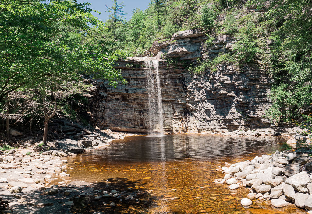
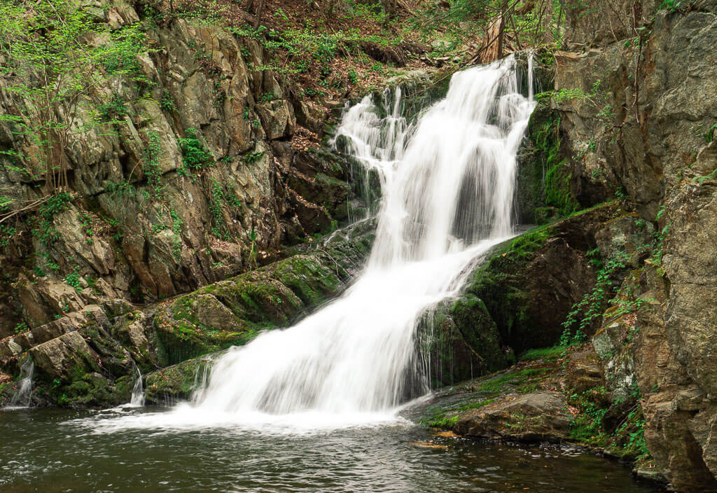
1. Awosting Falls – Minnewaska State Park
Difficulty: Easy
Length: 1.0 miles
Type of Hike: Out and Back
Elevation Gain/Loss: approximately 100 feet
Parking: Lower Awosting Parking Area at Minnewaska State Park
Entrance Fee: $10
Awosting Falls is one of the most popular and most visited features in Minnewaska State Park. This easy trail leads you to the base of the 60-foot tall waterfall which majestically drops into the Peterskill stream. We really enjoy this cute waterfall, that is why we have visited it every single season.
Find out everything you need to know about hiking to Awosting Falls in our detailed guide, Explore the Awosting Falls Trail in Minnewaska State Park.
How to Get There: To get to the falls, you will need to enter through Minnewaska State Park’s main entrance on Route 44-55. After pulling off the main road, you follow the roadway, which leads you to the ticket booth. Here, you purchase your daily pass for Minnewaska State Park and head straight to the Lower Awosting parking area.
2. Stony Kill Falls – Minnewaska State Park
Difficulty: Easy
Length: 1.5 miles
Type of Hike: Out and Back
Elevation Gain/Loss: approximately 226 feet
Parking: Park along Shaft 2A Round near the gate
Entrance Fee: $10
Stony Kill Falls is a beautiful hidden gem of Minnewaska State Park with a series of cascading waterfalls surrounded by the Shawangunk cliffs and lush forests. This trail really surprised us, especially after hiking past the viewing platform to the top of the falls.
Reaching Stony Kill Falls is a little tricky due to its location within the park. Before heading out on the trail, read more about it in our comprehensive guide to hiking to Stony Kill Falls.
How to Get There: The Stony Falls trailhead is 4.8 miles south of Minnewaska State Park’s main entrance. From there, drive southwest on US-44 E for about 2 miles. Then turn left onto Minnewaska Trail and make a quick left onto Rock Haven Road. Continue for 1.9 miles down Rock Haven Road before turning left onto Shaft 2A Road. Proceed down Shaft 2A Road until you reach a closed gate.
3. Verkeerderkill Falls – Minnewaska State Park
Difficulty: Moderate
Length: 6.0 miles
Type of Hike: Out and Back
Elevation Gain/Loss: about 700 feet
Parking: Sam’s Point Parking Area
Entrance Fee: $10
Verkeerderkill Falls is another picturesque waterfall found in Minnewaska State Park, surrounded by outstanding views of the Shawangunk region and Catskill mountains. It is the highest waterfall in the Shawangunks, dropping down 187 feet.
Two of our favorite times of year to visit Verkeerderkill Falls are the fall and spring. The fall time showcases the beautiful fall colors, while the spring emphasizes the powerful flow of the waterfall.
Before heading out to hike to this Hudson Valley waterfall, get all the information you need from our post Hike to the Unforgettable Verkeerderkill Falls in Minnewaska State Park.
How to Get There: Head to the Sam’s Point Area of Minnewaska State Park which is the southernmost section of the Park. This area is located at 400 Sams Point Road, Cragsmoor, NY 12420 about a 30 minutes drive from the park’s main entrance.
4. Rainbow Falls – Minnewaska State Park
Difficulty: Moderate
Length: 6.5 miles
Type of Hike: Loop
Elevation Gain/Loss: about 700 feet
Parking: Lower Awosting Falls Parking Area at Minnewaska State Park
Entrance Fee: $10
Deep into Minnewaska State Park is the charming Rainbow Falls. This waterfall is located in a valley surrounded by the Shawangunk cliffs. Reaching the falls requires the use of a variety of trails throughout the Minnewaska State Park trail system. As you wind through the park you will pass by romantic creeks, go through lush forests, walk along the historic carriage roads, and up and over rocks.
How to Get There: Enter through Minnewaska State Park’s main entrance on Route 44-55. Then you head straight to the Lower Awosting parking area. The trailhead to Rainbow Falls will be off to the far side of the parking lot.
5. Indian Brook Falls – Hudson Highlands State Park
Difficulty: Easy
Length: Short walk
Type of Hike: Out and Back
Elevation Gain/Loss: Very little
Location: On Indian Brook Road just up from Constitution Marsh Audubon Center and Sanctuary Entrance Fee: Free
Indian Brook Falls is hidden within the Hudson Highlands State Park in the Hudson Valley. We found this gem on our quest to visit all of the Hudson Valley waterfalls and loved the adventure of getting to the base of the Indian Brook Falls. Expect an ungroomed trail and be prepared to climb over some natural obstacles in your way.
To help you find a parking spot (which is very tricky in this area) and make the best out of your hiking experience, read more in our detailed guide How to See the Picturesque Indian Brook Falls.
How to Get There: Indian Brook Falls is located on Indian Brook Road just a little way up from the Constitution Marsh Audubon Center and Sanctuary.
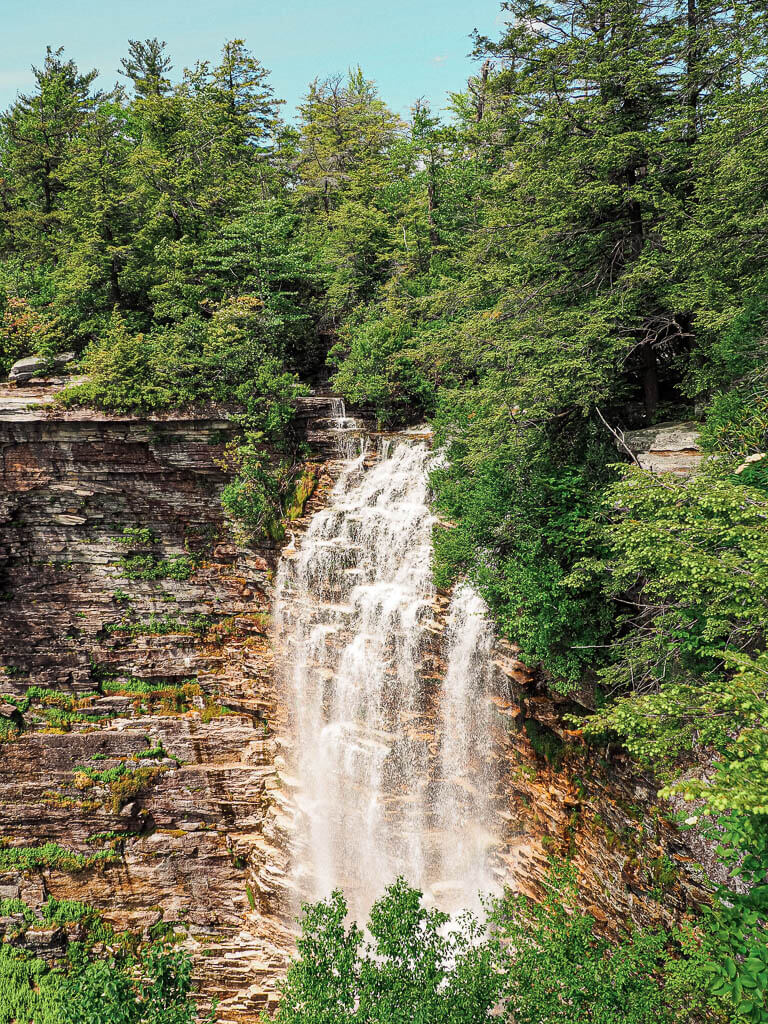
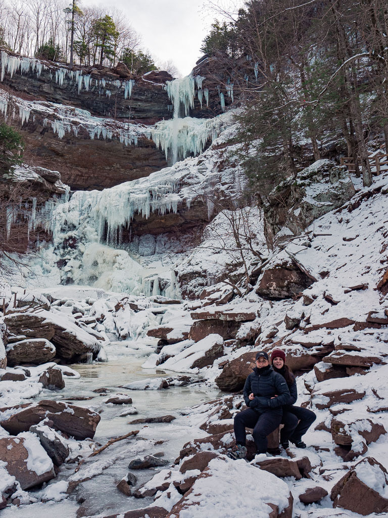
6. Kaaterskill Falls – Catskill Mountain
Difficulty: Easy
Length: 1.6 miles
Type of Hike: Out and Back
Elevation Gain/Loss: about 400 feet
Parking: Parking Lot on Laurel House Road
Entrance Fee: Free
This impressive 260-foot waterfall is one of the tallest falls in New York, which makes this trail one of the most visited Hudson Valley hikes with waterfalls.
You are able to observe this natural spectacle from the top of the falls and the bottom. We would highly recommend checking out the top viewing deck before heading down hundreds of stone steps to the base of the waterfall.
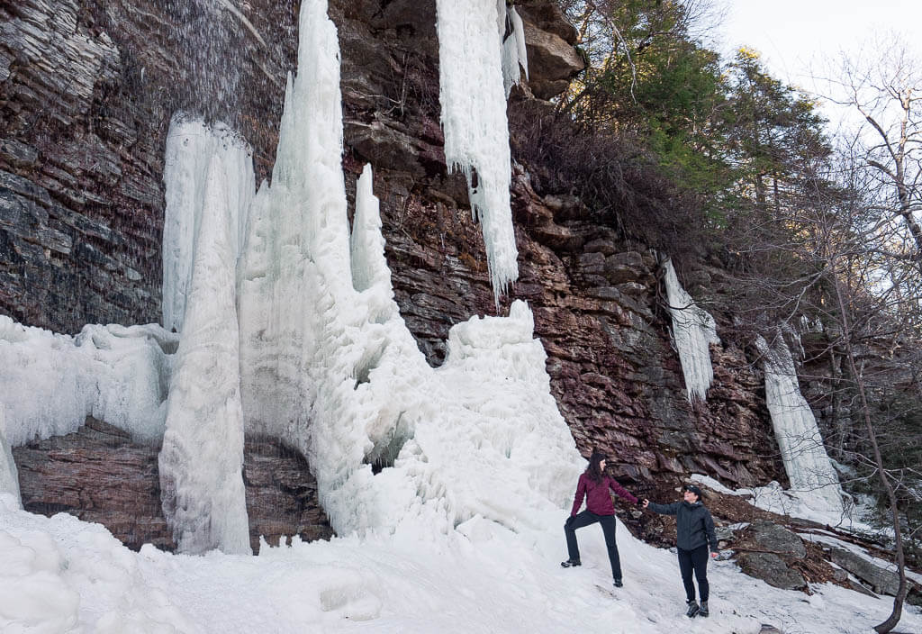
The best time to visit Kaaterskill Falls is in the spring after the snow melts when the water is at its strongest. At that time, you can even walk behind the waterfall. How cool is that? Another great time for a visit is in the winter when the falls are covered in snow and magical ice formations.
How to Get There: The parking lot for Kaaterskill Falls is at the end of Laurel House Road which is off of North Lake Road. From this parking lot, the upper viewing deck is about 0.3 miles. Once you reach the bridge along the trail, the base of the waterfall is just over 0.5 miles.
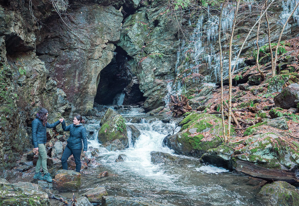
7. Dover Stone Church – Dutchess County
Difficulty: Easy
Length: 1.2 miles
Type of Hike: Out and Back
Elevation Gain/Loss: Very little
Parking: Dover Elementary School
Entrance Fee: Free
Dover Stone Church is a unique Hudson Valley waterfall located in a cavern and surrounded by a lush forest. You will feel like you are in a mystical land as you reach the secluded waterfall hiding in the cave. The trail to the falls is easy and accessible for all hiking levels which makes it a great place for hiking in Hudson Valley adventure.
After exploring the waterfall, you can choose from a few other trail options that lead you up a hill and through the woods. We opted to extend our hike to create a perfect loop to enjoy the outdoors and the scenic view of Dover Plains since the hike to the waterfall is rather short.
How to Get There: The trailhead is located on a private drive off of NY-22 in Dover Plains. Parking is easily available just up and across the street at Dover Elementary School, when school is not in session. In case you want to hike this trail when school is in session, park at Freshco 22 Plaza 3156 NY-22 Dover Plains.
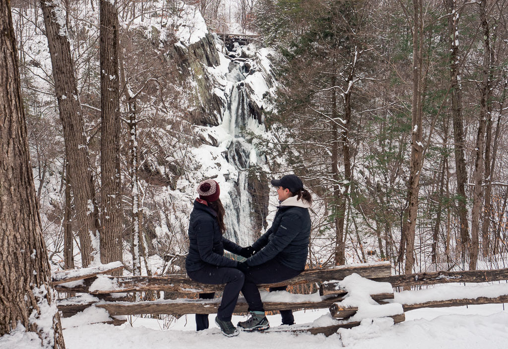
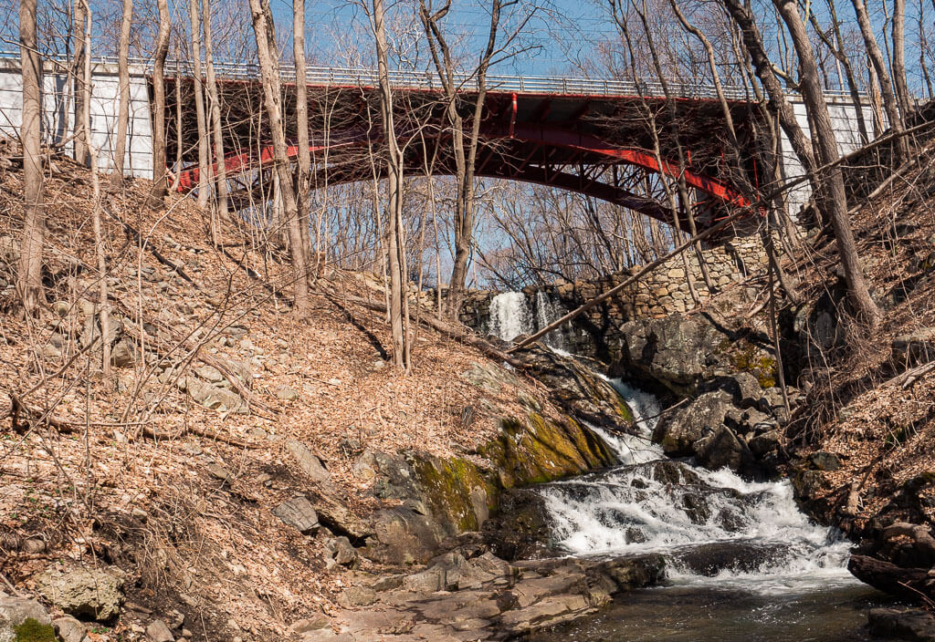
8. High Falls – High Falls Conservation Area
Difficulty: Easy
Length: 1.4 miles
Type of Hike: Out and Back
Elevation Gain/Loss: about 200 feet
Location/Parking: Park in the designated parking area for High Falls Conservation Area
Entrance Fee: Free
The High Falls Conservation Area has a few designated trails but the most prominent feature is the alluring waterfall. The 150-foot waterfall may not be the tallest in New York but it is higher than most of the falls in other states.
What makes the High Falls a must-do hike is that you are able to view the falls from a variety of vantage points. You can take in the view of the entire falls from an overlook or head down to the base to get up close and personal. All the trails are easily accessible for hikers of all ages.
As an added bonus, we did this trail in the wintertime. The trail was covered with nicely packed snow surrounded by glistening trees leaving you speechless by nature.
How to Get There: If you are traveling from New York City, getting to this trail will be a little bit of a journey. Located in the upper Hudson Valley Region, the trailhead is 2.5 hours straight up the NYS Thruway from Manhattan. Plugin the High Falls Conservation Area into your GPS and enjoy the ride.
9. Foundry Brook Waterfall – West Point Foundry Preserve
Difficulty: Easy
Length: Roughly a mile
Type of Hike: Loop
Elevation Gain/Loss: Very little
Parking: West Point Foundry Preserve Parking Area
Entrance Fee: Free
West Point Foundry Preserve is a relaxing hiking and walking area around old industrial ruins, a beautiful forest, and a stunning waterfall along the Foundry Brook stream. The best part is that the preserve also serves as an “outdoor museum”, where you can learn a lot about its role in the Industrial Revolution and the Civil War.
If you are looking for more quick and casual hiking in Hudson Valley experience this is where you want to go. After checking out the West Point Foundry Preserve, you will even find time to explore some of our nearby favorites, like the unique Constitution Marsh boardwalk trail or the charming town of Cold Spring.
How to Get There: Positioned on the south side of Cold Spring, New York, West Point Foundry Preserve is located at 80 Kemple Ave. Enter West Point Foundry Preserve into your GPS and you should have no problem finding your way no matter where you are coming from.
10. Old Croton Aqueduct Trail – Old Croton Aqueduct State Historic Park
Difficulty: Depends on how far you go on the trail
Length: 26.5 miles
Type of Hike: One way
Elevation Gain/Loss: Varies
Parking: Croton Dam Gorge Park
Entrance Fee: Free
The Old Croton Aqueduct Trail goes on for miles, winding through forests and communities along the way, following the old aqueduct from the 1800s. Although you could walk all 26.5 miles of the trail, you can also just tour bits and pieces at a time. There are many trail access points and parking areas along the way.
The Croton Dam, the waterfall, is located in the Croton Dam Gorge Park. If you are looking to see the falls, make sure to head to this section of the trail.
How to Get There: Getting to the Old Croton Aqueduct Trail will vary depending on what section of the trail you desire to cover. If you are headed to see the waterfall, you will want to drive to Croton Gorge Park on Yorktown Road in Cortlandt, New York.
Easy Hikes Hudson Valley
Get in the hiking mood with these quick and easy trails in the Hudson Valley which will for sure leave you speechless!
11. Cornish Estate Trail – Hudson Highlands State Park
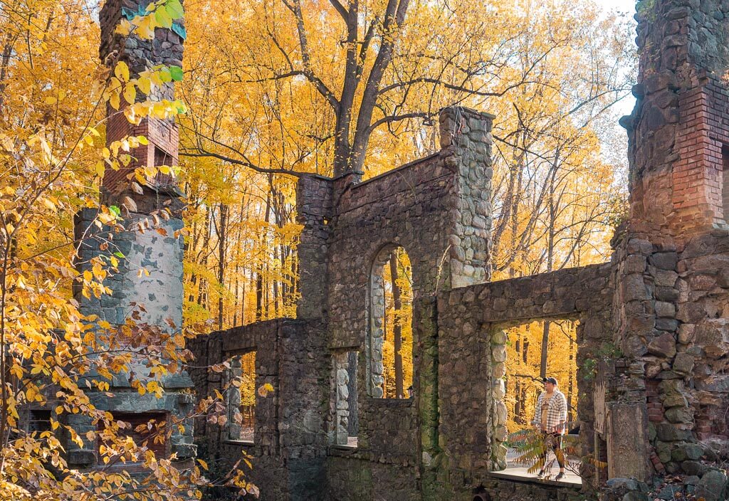
Difficulty: Easy
Length: 1.8 miles
Type of Hike: Out and Back
Elevation Gain/Loss: about 200 feet
Parking: Little Stony Point (Parking Area)
Entrance Fee: Free
In the mood for a scenic wooden hike with a special treat at the end? Then, the Cornish Estate Trail is your perfect Hudson Valley hiking trail. It is nestled in the Hudson Highlands State Park, one of the most popular hiking areas in New York State.
The Cornish Estate trail is one of the easiest hikes in the park and its accessibility makes it perfect for all ages and skill levels. The most interesting and special feature of the trail is the Cornish Estate Ruin. Simply follow the estate’s former driveway to reach it. Once an imposing building, nature took it back and made it to one of the most fascinating ruins in the state.
Want to find out more about this paradise for lovers of spooky places or history geeks who love to admire old structures? Then read more in our post How to Hike the Mysterious Cornish Estate Trail.
How to Get There: You can find the Cornish Estate trailhead off of Route 9D, just north of the town of Cold Spring. It is easily accessible and can be seen from the road.
12. Constitution Marsh Trail – Constitution Marsh Audubon Center and Sanctuary
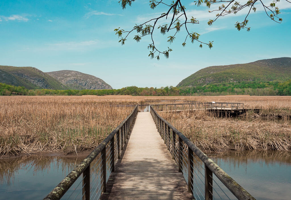
Difficulty: Easy
Length: 1.3 miles
Type of Hike: Out and Back
Elevation Gain/Loss: about 100 feet
Parking: Constitution Marsh Audubon Center and Sanctuary or Boscobel House and Gardens
Entrance Fee: Free
Hiking at the Constitution Marsh is an easy picturesque stroll through the woods to a scenic boardwalk overlooking a marshy area of the Hudson River. The trail provides excellent birding opportunities, as well as insight into the area’s ecosystem.
If you plan on visiting the Constitution Marsh, we would recommend adding the very close by Indian Brook Falls trail which is within walking distance up the road.
How to Get There: Constitution Marsh is located at the intersection of Warren Landing Road and Indian Brook Road in the town of Cold Spring. Parking is currently unavailable onsite. To visit this trail you will need to park at the nearby Boscobel House and Gardens or get dropped off by the Cold Spring Trolley or Uber at the intersection.
13. Lake Minnewaska Loop Trail – Minnewaska State Park
Difficulty: Easy
Length: 1.9 miles
Type of Hike: Loop
Elevation Gain/Loss: 260 feet
Parking: Upper Parking Lot at Minnewaska State Park
Entrance Fee: $10
Wander around Lake Minnewaska on a peaceful walk on the old carriage roads of the State Park. The Lake Minnewaska Loop Trail is a 2.0-mile stroll in the heart of the park with many connecting trails to other fascinating features. This is a great starting point if you have never visited Minnewaska State Park before.
When you really want to get the most out of your $10 park entrance fee, we would recommend taking advantage of all the other great activities the park has to offer. Join the fascinating Ranger Talks to learn more about the area, take a look at the new, modern Visitor Center, jump into the refreshing water at the public beach, or connect the Lake Minnewaska Loop trail with one of the other alluring hiking trails in the park.
How to Get There: Enter through Minnewaska State Park’s main entrance on Route 44-55. Then you head straight to the Upper parking area. The trailhead to the Lake Minnewaska Loop Trail is next to the park’s visitor center.
14. Sam’s Point Road Loop – Sam’s Point Preserve
Difficulty: Easy
Length: 3.1 mile
Type of Hike: Loop
Elevation Gain/Loss: 275 feet
Parking: Sam’s Point Parking Area
Entrance Fee: $10
On the southern end of the Minnewaska State Park, you have the jaw-dropping Sam’s Point Preserve Area. This section of the park is filled with numerous of the best hiking in Hudson Valley adventures making it a hotspot for outdoor lovers.
The Sam’s Point Loop Road encompasses a large portion of the Sam’s Point area along a well-maintained gravel road featuring Lake Maratanza. Along the trail, you also have easy access to the Verkeerderkill Falls trailhead and the Ice Caves. Don’t forget to make the short detour to the famous Sam’s Point Overlook for breathtaking views over the treetops.
This hike may not share all the excitement of the other trails in the park, but it is a beauty that is worth enjoying.
How to Get There: Head to the Sam’s Point Area of Minnewaska State Park which is the southernmost section of the Park. This area is located at 400 Sams Point Road, Cragsmoor, NY 12420, about a 30 minutes drive from the park’s main entrance.
15. Ninham Mountain Fire Tower – Putnam County
Difficulty: Easy
Length: 1.4 miles
Type of Hike: Out and Back
Elevation Gain/Loss: about 300 feet
Parking: Small Parking Area near Trailhead
Entrance Fee: Free
Are you looking for expansive views of the Hudson Valley? Then climb up the Ninham Fire Tower. On a clear day, you can even catch a glimpse of the iconic New York City skyline.
The trail leading to the Ninham Mountain Fire Tower is extremely easy as you will follow a maintained gravel road from the parking area to the tower. Although the trail does not present any challenging obstacles, it is a very moderate incline on your way up.
We visited the Fire Tower in the fall and were blown away by the array of colors dispersing throughout the trees. If you can, go when the sun sets down, since it is a top sunset watching destination, which normally doesn’t get overcrowded.
How to Get There: The trailhead is located in the town of Carmel Hamlet and can be found within the Ninham Mountain Multiple Use Area.
16. Vroman’s Nose Trail – Schoharie County
Difficulty: Easy
Length: 1.5 miles
Type of Hike: Loop Elevation Gain/Loss: 500 feet
Parking: Parking Area off West Middleburgh Road
Entrance Fee: Free
Vroman’s Nose is the most popular hiking trail in the Hudson Valley within Schoharie County because of its uniquely shaped “nose looking” feature. The trail begins with a steady, not-so-bad incline before reaching a trail junction where hikers have the option to go 1 of 2 ways. You can choose to hike up the short and steep trail, or the longer trail with less incline.
As you approach Vroman’s Nose, the views of Schoharie Valley begin to make its appearance. Continuing along the edge of the trail, you will come across a section better known as “the Dance Floor.” It is a large flat rock surface perfect for pausing and taking in the view.
How to Get There: You can find the main trailhead parking lot off West Middleburgh Road. It is a large grassy area with clearly marked signs. From the parking area, you should follow the old wooden road on the right and then enjoy the climb.
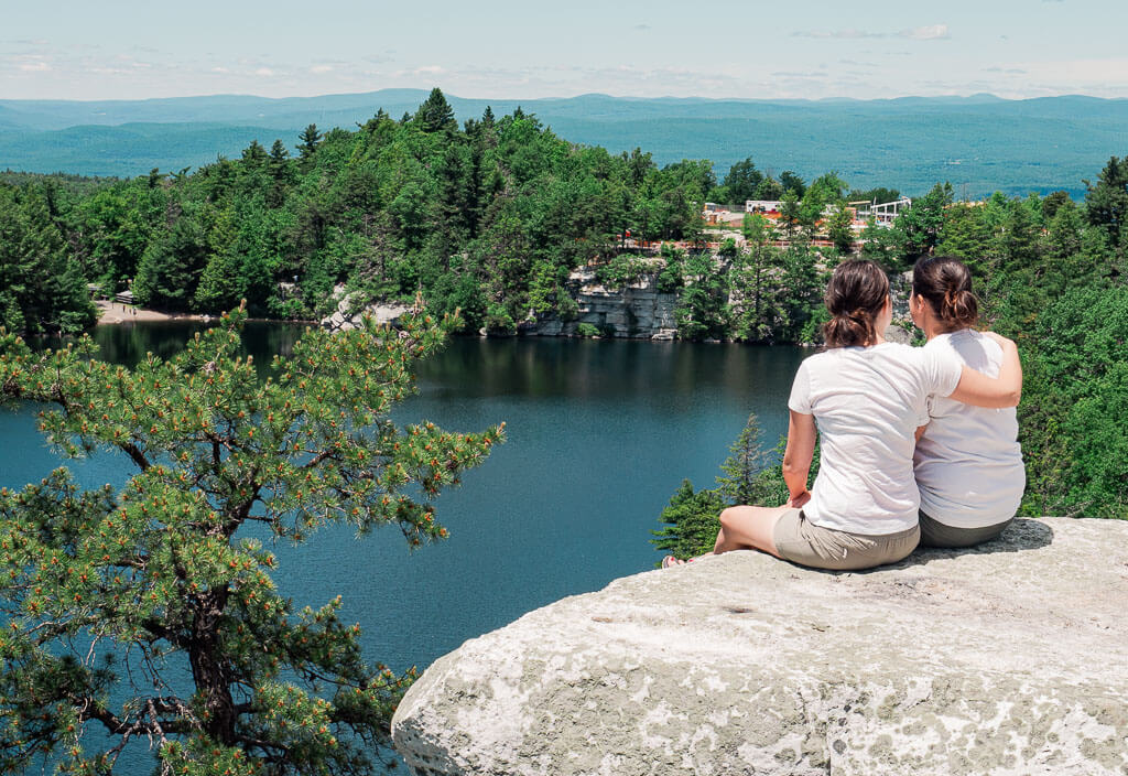
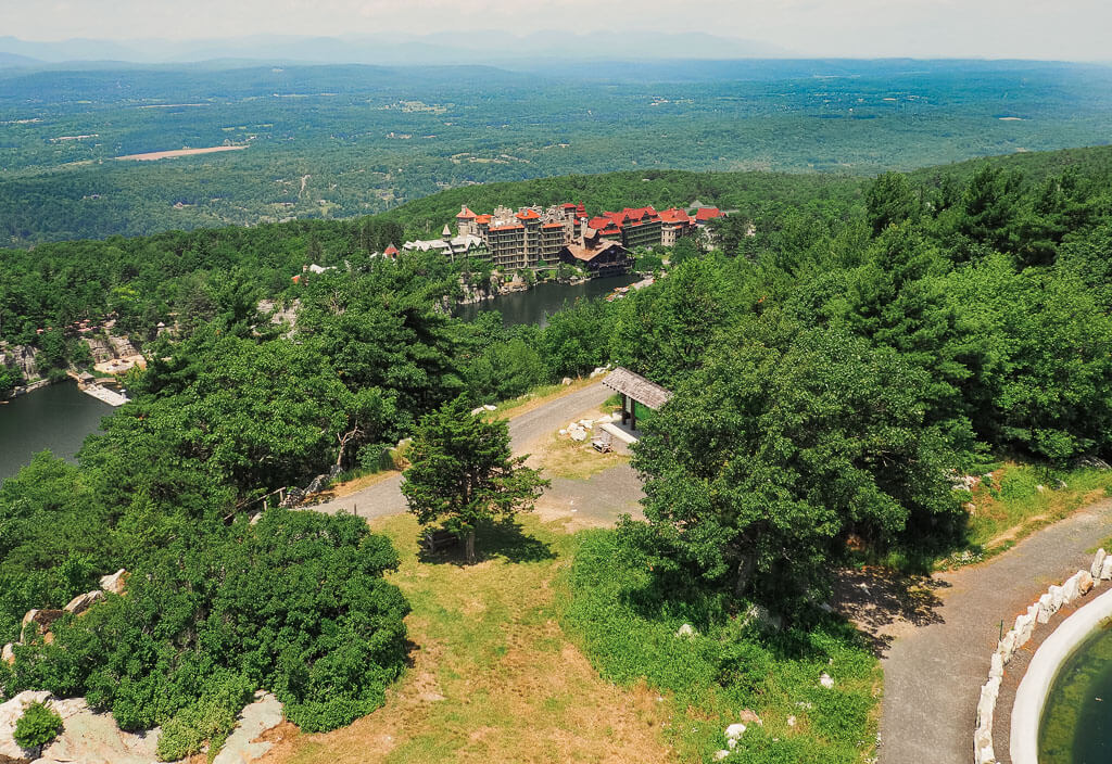
17. Sky Top Trail – Mohonk Preserve
Difficulty: Easy
Length: 1.6 miles
Type of Hike: Loop
Elevation Gain/Loss: 300 feet
Parking: Mohonk Preserve
Entrance Fee: $15-30 per hiker depending on the parking lot
Mohonk Preserve is beautifully located in the center of the Shawangunk Mountains near Minnewaska State Park. It is a designated National Historic Landmark which consists of 70 miles of carriage roads and 40 miles of trails for hiking and biking.
Sky Top trail is one of the most popular trails in the Mohonk Preserve. The trail begins near the exclusive Mohonk Mountain House. Walk along the glistening lake before you start the incline up the Shawangunk cliffs to superb views of the Shawangunks, the Mohonk Mountain House hotel, and the Mohonk Lake. At the top, you will also get rewarded with a free climb up to the Skytop Tower.
How to Get There: There are several different trailheads you can take to get to the Skytop Tower. To take the described, easy hike up the tower, you have to park at the Mohonk Mountain House. Unfortunately, this is the most expensive parking facility in the whole preserve. If you are willing to extend your hike, we would recommend parking at the Mohonk Gatehouse.
18. Walkway Over the Hudson
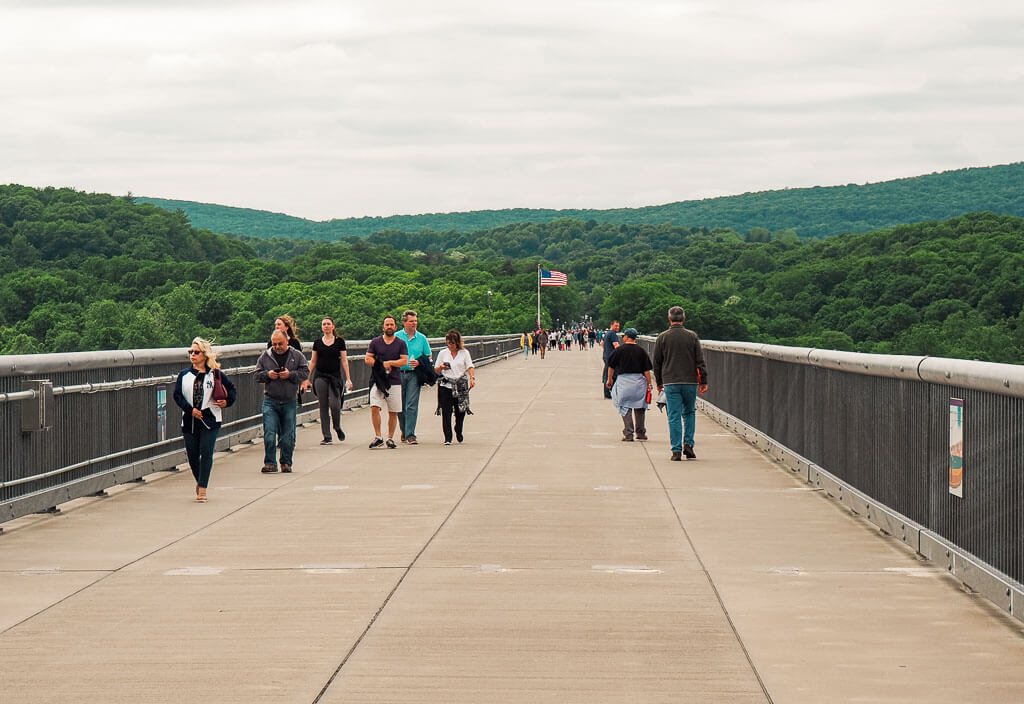
Difficulty: Easy
Length: 3.2 miles
Type of Hike: Out and Back
Elevation Gain/Loss: Very little
Parking: Designated Parking Areas
Entrance Fee: Free
Walkway Over the Hudson is not your ordinary hiking experience in the Hudson Valley. This easy 3.2-mile walk takes you on a pedestrian bridge over the Hudson River. It is a favorite attraction for locals and tourists alike.
As you walk over the bridge, you immediately take in the stunning panoramic views of the Hudson River which makes it hard not to stop every few steps to snap a photo. This is a great choice for hiking in the Hudson Valley if you are seeking an easy and calming stroll.
How to Get There: There are a few different ways to access the Walkway Over the Hudson.
- From the east side (Poughkeepsie) at 61 Parker Ave., Poughkeepsie, NY, 12601.
- If you are on foot, the stairs are located at Washington St. (131 Washington Street) You can find them 0.7 miles from the train station.
- If you need a handicapped access or arrive with your bike, there is an elevator entrance at Upper Landing Park on the Poughkeepsie side.
- From the west side you can access the bridge at 87 Haviland Rd in Highland.
Moderate Hikes Hudson Valley
Are you already warmed up with some of the easy hikes in the Hudson Valley? Or do you want to climb to some of the most impressive viewpoints immediately? These moderate hikes are worth all of your effort.
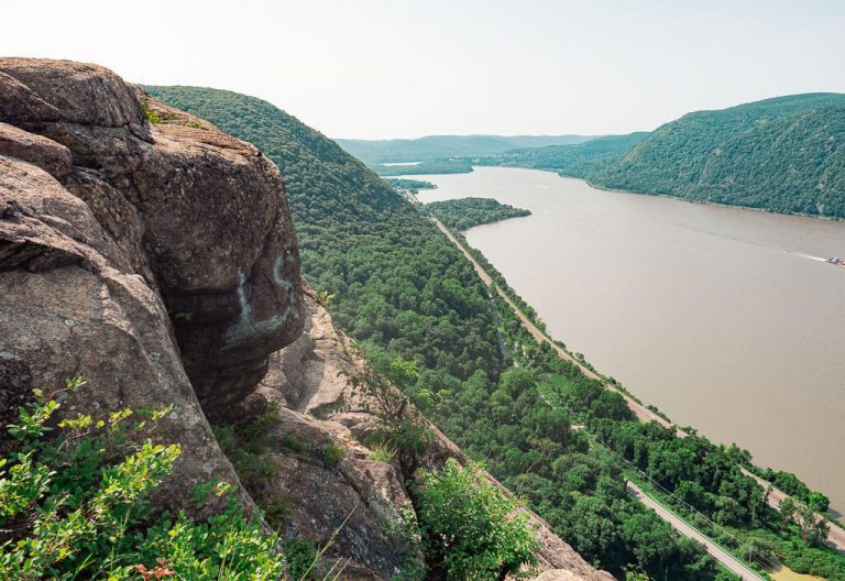
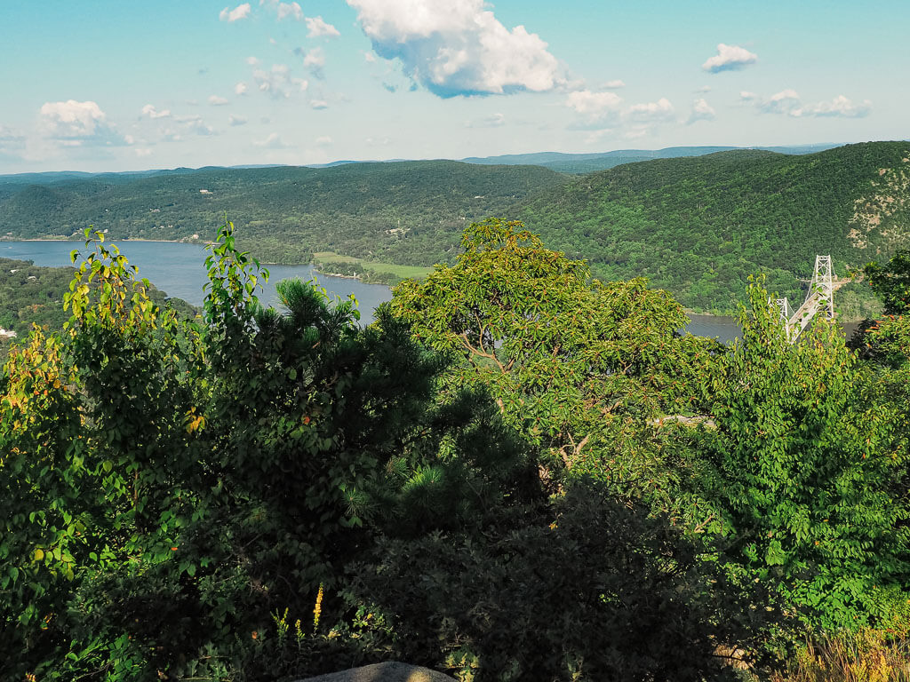
19. Anthony’s Nose – Hudson Highlands State Park
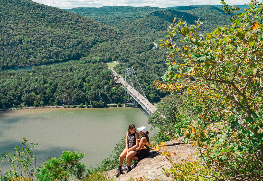
Difficulty: Moderate
Length: 1.9 miles
Type of Hike: Out and Back
Elevation Gain/Loss: 675 feet
Parking: Off of Route 9D in Cortlandt near the Bear Mountain Bridge
Entrance Fee: Free
Anthony’s Nose is a short, steep climb along part of the Appalachian Trail. It leads to one of the most impressive viewpoints in the northern part of Westchester County. You will be overlooking the stunning Hudson River, spectacular waves of mountain ranges, and the iconic Bear Mountain Bridge.
Being just a short drive or train ride from New York City, this trail sees its fair share of hikers. We would highly recommend hiking this trail during the weekdays or in the early hours of the day. Parking is limited and is a constant struggle for hikers to find a spot.
This highly sought-after trail is easily one of the top-rated trails to go hiking in Hudson Valley. Find out more in our post about hiking on the Anthony’s Nose trail.
How to Get There: You can access this trail by train or car. By train, you will want to take the Metro-North from Grand Central to Cortlandt via the Hudson Line. Then pick up an Uber or Lyft for a quick 10-minute drive to the trailhead. By car, it is about a 60 to 90-minute drive from New York City depending on your starting point and traffic.
20. Giant Ledge and Panther Mountain Trail – Catskill Mountains
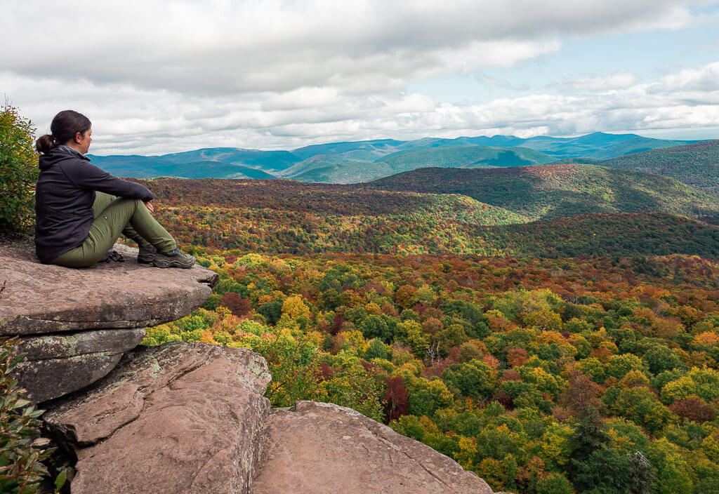
Difficulty: Moderate
Length: 6.3 miles
Type of Hike: Out and Back
Elevation Gain/Loss: about 2,000 feet
Parking: Alongside the road at the trailhead
Entrance Fee: Free
This is definitely a hike in the Hudson Valley you will not want to miss out on. The Giant Ledge and Panther Mountain Trail is a popular fall favorite with views overlooking the Catskill Mountains. Be ready for a leg-burning climb as you make your way up. At the top, you won’t even remember that your legs are tired because you will be awestruck by the amazing views of the Giant Ledges and the vast colors of the Catskill Mountains. This trail is known to be muddy so be prepared with proper footwear.
If you are not up for a longer, more intense trail, just hike until Giant Ledge and turn around. You will still be able to enjoy the breathtaking views but can save some energy for the next hiking in Hudson Valley adventure.
After such an exhausting hike, you deserve a delicious dinner. Read more about visiting the cute town of Phoenicia below to end your day of hiking.
How To Get There: Depending on the direction you are coming from, it is probably the easiest to take the New York State Thruway to Kingston and enjoy the scenic drive on Route 28 towards Phoenicia. The Giant Ledge trailhead is on Oliverea Road.
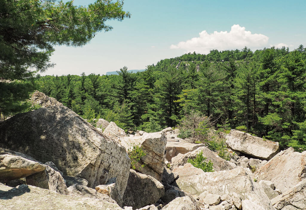
21. Sam’s Point Ice Caves Trail – Sam’s Point Preserve
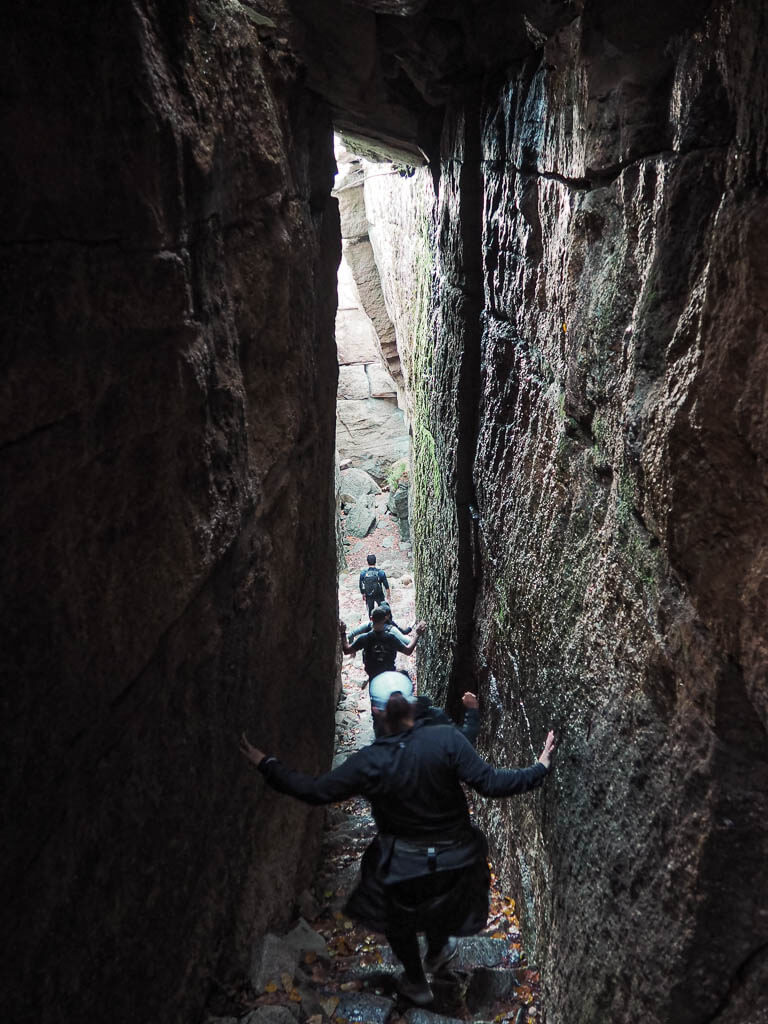
Difficulty: Moderate
Length: 3.3 miles
Type of Hike: Out and Back
Elevation Gain/Loss: 530 feet
Parking: Sam’s Point Parking Area
Entrance Fee: $10
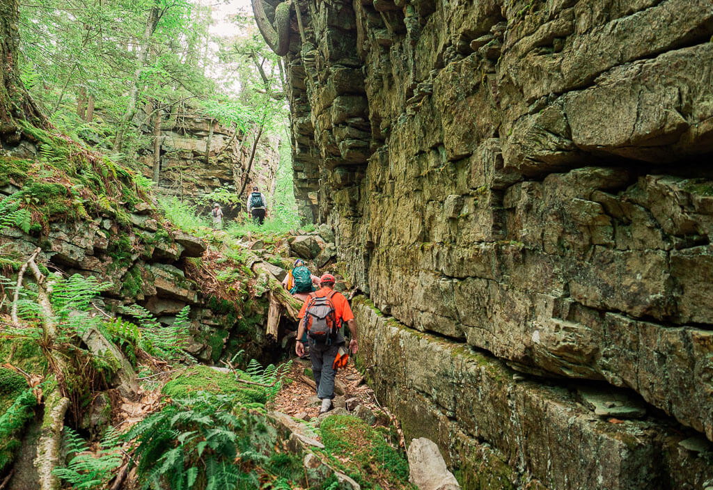
Explore the Shawangunks by going down into the chilly Ice Caves of Sam’s Point. The trail will lead you to a set of rock stairs surrounded by cliffs. There are sections of the trail that are pretty narrow as you go in and out through the small crevices of the caves.
The name of the trail is definitely illusional. Personally, we expected a little more of the caves. You will have a lot of fun squeezing through the rocks and it is still a great hike in the Hudson Valley, but don’t expect any ice formations in the caves.
That said, this trail is not open all year round. During the winter season, the trail is closed due to unsafe conditions. Before heading out to hike the Ice Caves, we highly recommend checking the park’s website for up-to-date trail information.
Don’t want to stop your hiking in Hudson Valley adventure with this trail? Continue your Minnewaska State Park hiking experience by adding the Verkeerderkill Falls trail. The trailhead is located within a short walking distance from the Ice Caves.
How to Get There: Head to the Sam’s Point Area of Minnewaska State Park which is the southernmost section of the Park. This area is located at 400 Sams Point Road, Cragsmoor, NY 12420, about a 30 minutes drive from the park’s main entrance.
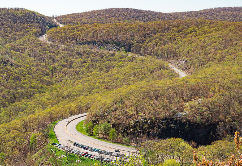
22. Storm King Trail – Storm King State Park
Difficulty: Moderate
Length: 2.4 miles
Type of Hike: Loop
Elevation Gain/Loss: 630 feet
Parking: Parking Area on East Side of Mountain Road
Entrance Fee: Free
The Storm King Mountain hike offers an opposing view from the popular Breakneck Ridge trail from across the river. Similar to its counterpart, the hike up Storm King Mountain showcases excellent outlooks of the Hudson River and other prominent Hudson Valley features.
To enjoy these views, it will require an extended steep uphill climb, before it flattens out to a more mellow hike through a forested area. The top offers open views and is a perfect place to have a picnic lunch to rest and take it all in.
How to Get There: Head to Storm King State Park where there is a parking lot along the northbound side of Mountain Road (9W). The trailhead to the summit is just bordering the north side of the parking lot.
23. Overlook Mountain – Overlook Mountain Wild Forest
Difficulty: Moderate
Length: 4.6 miles
Type of Hike: Out and Back
Elevation Gain/Loss: 1,400 feet
Parking: Limited Parking at Trailhead
Entrance Fee: Free
Head up to the Catskill Mountain region to enjoy a wonderful hike up Overlook Mountain. Hiking this trail is a nice addition to a trip to one of the top charming Hudson Valley towns of Saugerties and Woodstock.
However, this trail is not just a walk in the woods. The Overlook Mountain trail consists of steep inclines which gain quite a bit of elevation in the 4.6 miles to the summit. At just about 2.0 miles into the hike, you will reach the ruins of the Overlook Mountain House. From there, it will take about another 0.5 miles to reach the Fire Tower at the Summit.
At this point, you may be a little exhausted, so take a break before climbing up the Fire Tower. If you happen to be hiking on a clear day, you may even be able to see distinct Hudson Valley landmarks.
How to Get There: Park in the small parking lot at the trailhead located on Meads Mountain Road. Then follow a gravel pathway to the red-blazed trail markers which bring you to the top of Overlook Mountain. The quickest and easiest way to get to the trailhead is heading North on Interstate 87, also known as the New York State Thruway.
24. Perkins Memorial Tower Observatory Loop- Bear Mountain State Park
Difficulty: Moderate
Length: 3.8 miles
Type of Hike: Loop
Elevation Gain/Loss: about 1,000 feet
Parking: Parking at Bear Mountain State Park
Entrance Fee: $10
Bear Mountain State Park is a top hiking in Hudson Valley destination with an expansive trail system and iconic views. Perkins Memorial Tower Observation Loop attracts visitors from all over New York State for its 360-degree view of the surrounding area atop Bear Mountain. Soak up the area’s beauty as you climb to the top of the tower. The tower is usually accessible from April to late November, depending on the weather conditions.
After your hike, you should enjoy the beautiful Hessian Lake and the State Park a little longer. Just take a break on one of the benches around the lake, or even rent one of the pedal cruisers for some water fun. By the way, Bear Mountain State Park is also a very popular place to have a tasty BBQ.
How to Get There: If you are coming from NYC, you can take the Metro-North train or drive your own car to the park. The state park is located on the west side of the Bear Mountain Bridge opposite the Anthony’s Nose hike.
25. Bonticou Crag Trail – Mohonk Preserve
Difficulty: Moderate
Length: 2.3 miles
Type of Hike: Loop
Elevation Gain/Loss: about 500 feet
Parking: Spring Farm Parking Area
Entrance Fee: $15 per hiker
The Bonticou Crag Trail gives hikers a little challenge with a short, steep rock scramble to the top. This section of the trail is what draws people in. It will take roughly 15 to 20 minutes to complete the scramble and is more difficult for some than others. Don’t forget to keep a lookout for the trail markers every once in a while as you are scrambling. You want to make sure you are still on the trail to Leave No Trace.
Since this trail is relatively short and you might have to drive a little to your destination, you may want to think about connecting the Table Rock trail to your hiking in Hudson Valley adventure.
How to Get There: Head north up the New York State Thruway. Take exit 18 for New Paltz to Upper 27 Knolls Road in High Falls. The trail is located in the Mohonk Preserve. It is best to park at the Spring Farm Parking Area of the Preserve.
26. Reeves Brook Loop Trail – Harriman State Park
Difficulty: Moderate
Length: 3.8 miles
Type of Hike: Loop
Elevation Gain/Loss: 900 feet
Parking: Parking Area at Trailhead
Entrance Fee: Free
Harriman State Park offers unlimited outdoor adventures from hiking, biking, swimming, and more. The Reeves Brook Loop trail is easily a hiking favorite. This enjoyable laidback hike with a little scrambling mixed in leads you wandering through the open woods, along scenic streams and small waterfalls.
Our best advice for hiking this trail is to pay attention to the trail map. The Reeves Brook Loop trail connects with other trails several times. If you want to make sure you stay on your chosen route, we would suggest using the Alltrails App. We actually got lost on this trail and had to add on some miles. Good thing we don’t mind getting lost too much! It just gives you more time to admire the beautiful landscape.
How to Get There: Harriman State Park is located just about an hour north of Manhattan, New York City. Simply jump on the New York State Thruway north to the Sloatsburg exit. From the popular Woodbury Premium Outlet Center, it is 25 minutes drive south.
Strenuous Hikes Hudson Valley
Even if you are not an experienced hiker, you should not hold back on these Hudson Valley favorites. They sound harder than they are! Simply aim a little higher and trust yourself.
27. Breakneck Ridge Trail – Hudson Highlands State Park

Difficulty: Hard
Length: 1 mile = Short Loop, 2.1 miles = Moderate Loop, 2.8 miles = Long Loop
Type of Hike: Loop
Elevation Gain/Loss: 1,250 feet -1,670 feet
Parking: Along the Road near Trailhead
Entrance Fee: Free
Breakneck Ridge is one of the most popular and favorite hiking trails in the Hudson Valley, due to the incredible views from atop. Although this trail is marked as difficult, it does offer a few different trail options to fit your hiking level.
Being a popular Hudson Valley hiking trail, you can always assume it will be crowded and difficult to find a parking spot. We tried multiple times on the weekends but did not succeed. When we decided to complete the Breakneck Ridge trail on a weekday, we could easily get a parking spot close to the trailhead. Another option would be to start your hiking day very early in the morning.
While hiking the Breakneck Ridge trail, we were very disappointed by how much trash, especially empty water bottles, we found on the trail. Please always remember to carry out what you bring in and Leave No Trace.
How to Get There: The Breakneck Ridge trail is located between Cold Spring and Beacon. You will find designated parking areas along Route 9D. The trailhead is right next to the tunnel, so if you can try to park as close as possible to save yourself some annoying time hiking on the road.
28. Mount Beacon Fire Tower – Hudson Highlands State Park
Difficulty: Hard
Length: 4.4 miles
Type of Hike: Out and Back
Elevation Gain/Loss: about 1,500 feet
Parking: Parking Area at Trailhead
Entrance Fee: Free
Located in one of Hudson Valley’s vibrant towns is the Mount Beacon Fire Tower. The trail’s prime location on the edge of town and its close proximity to the Beacon train station makes it even more accessible than other Hudson Valley hikes.
This hike is mainly difficult due to its long, steep incline. The trail starts off with a short gravel path to a climb up a set of metal stairs and continues with another forever long gravel incline. You are sure to feel a burning sensation in your quads and calves as you make your way up. Once you reach the overlook, your legs will be thanking you for a break.
To reach the fire tower, you will have to do just a little more hiking. On a clear day, you may be able to spot some other distinct landmarks in the area. Overall, the hike is well worth the effort.
Top Tip: Watch out for snakes! Usually, we don’t see snakes while hiking the Hudson Valley but when we did this hike during the spring, we encountered them everywhere. Some just looked like sticks on the hiking trail, so keep your eyes open not to step on them.
How to Get There: The trailhead is just under 2 miles from the Beacon Train Station on Route 9D. The parking lot at the trailhead is clearly marked with a sign for Mount Beacon.
29. Gertrude’s Nose – Minnewaska State Park
Difficulty: Hard
Length: 7.5 miles
Type of Hike: Loop
Elevation Gain/Loss: about 1,100 feet
Parking: Upper Parking Area at Minnewaska State Park
Entrance Fee: $10
Gertrude’s Nose is a popular Hudson Valley attraction in Minnewaska State Park. The beginning part of the hike has you wandering halfway around Lake Minnewaska before you make your way on a forested footpath. The absolute highlight of the trail is the walk along the beautiful ridges with picturesque views of the surrounding valleys.
If you are looking for a day out on the trails, hiking the famous rock formation Gertrude’s Nose in the Shawangunk Mountains is the one for you as it encompasses a wide variety of hiking terrain while showcasing the beauty of Minnewaska State Park.
How to Get There: Enter through Minnewaska State Park’s main entrance on Route 44-55. Then you head straight to the Upper parking area. The trail leading to Gertrude’s Nose is near the park’s visitor center.
30. High Peters Kill Trail – Minnewaska State Park
Difficulty: Hard
Length: 6.5 miles
Type of Hike: Out and Back
Elevation Gain/Loss: 1,650 feet
Parking: Lower Awosting Falls Parking Area at Minnewaska State Park
Entrance Fee: $10
High Peters Kill in the stunning Minnewaska State Park is a very forestry trail through swampy sections covered with planks, cute streams, and dramatic cliffs leading to a waterfall. You can also find historic remnants, like the graveyard of the Enderly’s, whose families owned farms, sawmills, and blacksmith forges in the area.
Top Tip: You can easily confuse the High Peters Kill Trail with the easy 1.9 miles Peterskill Falls trail which is also located in Minnewaska State Park. Even when you end up doing the short hike, we assure you will have a fun-filled hiking experience.
How to Get There: Enter through Minnewaska State Park’s main entrance on Route 44-55. Then you head straight to the Lower Awosting parking area. The trailhead for the High Peters Kill trail will be off of the parking lot.
31. Shingle Gully – Minnewaska State Park
Difficulty: Hard
Length: 4.0 miles
Type of Hike: Guided Hike
Elevation Gain/Loss: 1,500 feet
Parking: Notified by the Park Service
Entrance Fee: Free
The Shingle Gully hike is like no other trail you have hiked in Minnewaska State Park and one of our top recommendations. It is an unmarked, ungroomed, adventurous trail only accessible with a guide. Throughout the all-day hike, you will bushwack, climb river beds, scale rocks, and enter several narrow caves. Your endurance will definitely be put to the test on this hike.
To experience the most remote section of the Shawangunks, you will need to reserve a spot on a guided hike. Guided hikes are offered a few days out of the year during the spring, summer, and early fall. Reservations have to be booked quickly otherwise they will sell out. It is best to occasionally check the park’s website to not miss your opportunity for one of the best hiking in Hudson Valley experiences.
How to Get There: The Shingle Gully area is part of Minnewaska State Park, but is located near Sam’s Point Area. We will not provide specific directions to the trailhead because the trail is only able to be accessed on a guided hike. All the information you need will be shared with you once you have booked your hike.
32. Labyrinth and Lemon Squeeze – Mohonk Preserve
Difficulty: Hard
Length: 4.5 to 5.5 miles, depending on the route
Type of Hike: Out and Back
Elevation Gain/Loss: 1,000 feet
Location: Mohonk Preserve
Entrance Fee: $15 – $30
The Labyrinth trail will have you rock scrambling over, and squeeze you through a massive jumble of boulders. While making your way up to the Sky Top Tower with fantastic views of the Mohonk Preserve, you will also pass the Lemon Squeeze, a 100-foot rock crevice. Hiking this trail may be hands down one of the most unforgettable hiking trips in the Hudson Valley.
With the trail being very technical it is not open all year round. The unpredictable winter weather leaves this trail closed to all hikers with usually an unknown open and closing date. It is best to call Mohonk Preserve or check their website before heading out.
How to Get There: Head to Mohonk Preserve located in New Paltz, New York. You can choose to make this a short loop (4.5 miles) or a long loop (5.5 miles). For the short loop, park at the Mohonk Mountain House, which requires a $30 fee per hiker. If you don’t mind the extra mile, save some bucks and park at the Mohonk Gatehouse for $15 per hiker.
33. Major Welch Trail – Bear Mountain State Park
Difficulty: Hard
Length: 4.1
Type of Hike: Out and Back
Elevation Gain/Loss: about 1,200 feet
Parking: Parking Area at Bear Mountain State Park
Entrance Fee: $10
Start on the flat and easy loop trail around the beautiful Hessian Lake before ascending through the woods and challenging yourself on making your way up to some massive rock faces. On top of Bear Mountain, you will realize immediately that this climb was well worth all your effort. Take in the gorgeous views of the Perkins Memorial Tower, the Hudson River, and the Bear Mountain Bridge.
By the way, if you like this trail, you can thank Major Welch. He was the park’s first General Manager who took an important role in creating the stunning hiking trail system in the Harriman and Bear Mountain State Parks.
Top Tip: We are huge fans of loop trails, so if you don’t mind extending your hike, we would highly recommend taking the Perkins Memorial Tower via Appalachian Trail back to Hessian Lake.
How to Get There: If you are coming from NYC, you can take the Metro-North train or drive your own car to the park. The state park is located on the west side of the Bear Mountain Bridge opposite the Anthony’s Nose hike.
Hudson Valley Trail Map
The Hudson Valley Hiking Trail Map below indicates the location of the 33 Hudson Valley hikes listed above. Each trail is color-coded depending on which region of the Hudson Valley they are in. Green represents the Lower Hudson Valley, yellow the Mid-Hudson Valley, and red the Upper Hudson Valley.
Be sure to save this map for when you are ready to hit the trails.
What to Know about Hiking in Hudson Valley
1. Entrance Fees
To access some of the trailheads of our hiking in Hudson Valley list you have to pay an entrance fee. These trailheads are mainly those which are located in New York State Parks and Preserve areas. The entrance fee for New York State Parks varies but is usually $10 per car for the day in the Hudson Valley area.
If you plan to visit one of the trails on the list which requires a fee, such as Minnewaska State Park, we would recommend spending the whole day in the park to connect as many trails as possible.
For example, Trails that can easily be done in one trip to Minnewaska State Park are Gertrude’s Nose, Lake Minnewaska Loop Trail, and Awosting Falls.
Top Tip: If you live in New York or visit it frequently, you can save a lot of money on visiting New York State Parks when purchasing an Empire Pass. The pass costs $80 dollars for access to all State Parks and the State Dept. of Environmental Conservation areas for 1 year.
2. Best Season for Hiking in Hudson Valley
Every season is awesome to go hiking in the Hudson Valley. But from our experience, hitting the trails is the most fun in spring and fall, since the weather in this region can be very drastic. The summers can be well close to 100 degrees Fahrenheit, while it can get below freezing in the winter.
In spring and fall, you find perfect temperatures for hiking in Hudson Valley. On top of that, the Hudson Valley fall draws hikers in with the beautiful fall foliage, while the spring attracts people to admire the rushing of the waterfalls. Especially during these times of the year, you have to be prepared for sharing the trails with a lot of other hikers.
Also, make sure to always bring the appropriate hiking gear for the current weather conditions.
3. Crowded Hiking Trails
Hiking in Hudson Valley is very popular which means the trails can be very crowded. The trails we have had the most difficulty finding parking with are Breakneck Ridge Trail, Anthony’s Nose, Giant Ledge and Panther Mountain Trail, Kaaterskill Falls, and Storm King Mountain.
To enjoy the trails without a huge crowd, do your best to avoid weekends and holidays. If these are the only times you are available to go hiking, we highly suggest getting to the trailheads as early as you can. Parking at the trails fills up quickly. We usually wait to do the more popular Hudson Valley hikes when we know we can go during an unpopular and undesirable time.
One of those more unpopular times to go hiking in the Hudson Valley is in the winter. The colder weather usually turns most hikers away from the trails. So if you don’t mind bundling up, try to hit some of the trails then. Just keep in mind that not all of the hikes will be suitable during that time of the year.
With these recommendations in mind, don’t worry about the crowds too much. Even when you are unlucky finding a parking spot at one of the trails, there are plenty of other trails to choose from. A lot of hikes are in close proximity to each other, which gives you the chance to complete another adventure that day.
Best Towns in the Hudson Valley to Explore after Your Hiking Trip
The following list consists of our favorite towns in the Hudson Valley region from Orange and Ulster County on the western side of the river, to Putnam and Dutchess on the eastern side of the river. Enjoy exploring them after a fun-filled day of hiking!
Cold Spring
Cold Spring, rated as one of the most picturesque towns in the Hudson Valley, is located approximately 2 miles north of Indian Brook Falls. Wander along some of the most important industrial sites at the “outdoor museum” West Point Foundry Preserve, find a souvenir in one of the unique shops, or dine in one of the charming restaurants.
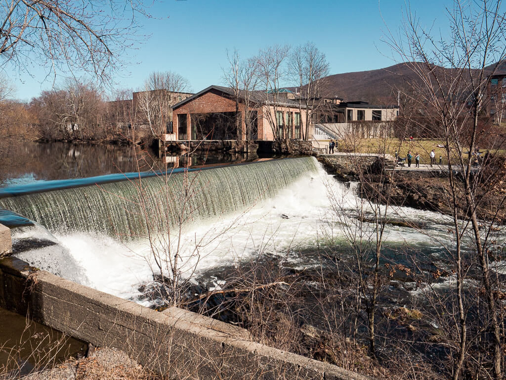
Beacon
The hipster industrial town of Beacon is located in the Hudson Valley’s Dutchess County. Take a walk down Main Street for lively restaurants, original bars, and unique shops. You can’t miss Beacon Falls, the town’s beautiful waterfall.
Newburgh
Just across the river from Beacon is Newburgh. Hop on the Newburgh Beacon Bridge and enjoy a special dinner at the Newburgh waterfront. There are a variety of restaurants with different price ranges you can choose from which all sit along the Hudson River. It is a perfect dinner spot after a day of hiking in Hudson Valley.
New Paltz
New Paltz is a little, funky, artsy town located in the Shawangunk Mountains. Head to one of the unique eateries or grab a drink at a bar downtown. Just a few minutes away from the town’s center you can already be hiking in Minnewaska State Park or Mohonk Preserve.
Hyde Park
Brush up on some presidential history by visiting the home of Franklin D. Roosevelt, the 32nd President of the United States. Hyde Park is located in Dutchess County and was recently named one of the safest small towns in America. If you just happen to be an outdoor lover and history geek, then a visit to Hyde Park is a must when hiking in Hudson Valley.
Phoenicia
Phoenicia’s prime location in the Catskill Mountains makes this town an ideal base for outdoor adventures. After enjoying some trails in the woods soaking up the jaw-dropping fall foliage, reenergize with some food at the top-rated Phoenicia Diner and finish with a drink at Woodstock Brewing.
Woodstock
Although the famous 1969 Woodstock Music and Art Festival did not take place here, the town is still very musical and also has a long history of attracting artists, musicians, writers, and more. As you walk around the town’s main streets, admire the galleries and boutiques as the town retains its artistic charm.
Hudson Valley Accommodations
New York’s Hudson Valley is filled with beautiful accommodations throughout the region. But searching for hotels just located in the Hudson Valley may be overwhelming and won’t point you in the direction you are looking for.
Check out this list of towns you find close to the most popular State Parks and other hiking areas in New York for your perfect night rest:
| State Parks and Other Hiking Areas | Towns To Stay |
| Bear Mountains State Park | Stony Point |
| Catskill Mountains | Saugerties Area |
| Hudson Highland State Park | Cold Spring / Beacon |
| Minnewaska State Park area | New Paltz |
| Mohonk Preserve | New Paltz |
What is your Favorite Hiking in Hudson Valley Experience? Would You Add Other Hikes?
Let us know in the comments below!
Our Other Resources for Hudson Valley’s State Parks
- 13 Most Scenic Minnewaska State Park Trails
- Hike the Unforgettable Verkeerderkill Falls in Minnwaska State Park
- Explore the Beautiful Awosting Falls Trail in Minnewaska State Park
- Stony Kill Falls: Best Kept Secret in Minnewaska State Park
- Beautiful Anthony’s Nose Hike: All You Need to Know
- How to See the Picturesque Indian Brook Falls
- How to Hike the Mysterious Cornish Estate Trail
- Hiking Breakneck Ridge: How Tough Actually is this Hike
- How to Hike the Indian Ladder Trail at Thacher State Park
You Might Also Like
- Quotes: 100+ Hiking Quotes to Inspire your Future Adventures
- Hiking: 15 Most Helpful Hiking Apps to Download
- Hiking: What You Should be Packing for a Hike: The Essentials + Extras
- Hiking: 100+ Best Gifts for Hikers to Buy
- Gifts: 50 Best Gifts for Outdoorsy Women Created by Outdoor Lovers
- Road Trip: 31 Best Games for Road Trips for Adults to Beat the Boredom
- Upstate New York: 34 Top Rated Best Hikes Upstate New York
- Upstate New York: A Complete Guide to Fall in Upstate New York
- Cold Spring: The Ultimate Guide to 11 Best Cold Spring Hiking Trails
- Hudson Valley: 25 Best Apple Picking in Hudson Valley Spots to Visit
- Waterfalls: 57 Spectacular Waterfalls in NY You Have to See
- New York City: 59 Best Places in Manhattan to Visit for All Visitors
- New York City: 4 Day New York Itinerary: How to See the Best of NYC
Save this Post for later on Pinterest!
Did you like this post? Subscribe to our newsletter and we’ll send you more unique travel tips, updates, and even FREE content!