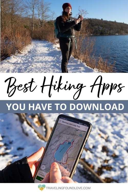
15 Most Helpful Hiking Apps to Download In 2023
There are millions of hiking apps out there. Some are extremely useful and make your life so much easier and some you just download to figure out they are simply not for you!
As nature lovers, we don’t know anything better than to go outside for a nice hike. We started with random trails around the corner but quickly that wasn’t enough anymore. We were looking for more challenging hikes in New York State but also for adventures for our cross-country road trips.
The best app for hiking trails was our lifesaver. Not only for the process of finding the right trails, but also to plan the best route, and not to get lost on the actual trail. Since then, they are our loyal companions whenever we plan an outdoor adventure.
To save you from spending wasted time downloading the wrong hiking apps, look at these 15 approved best apps for hikers which will get you on the perfect trail as soon as possible.
This post may contain affiliate links. If you make a purchase through them, we get a small commission at no extra cost to you. It helps us create free content for you to enjoy. Learn more about our disclaimer here. Thanks for your support!
Top 5 Gear for Hiking
Insulated Water Bottle: We found out very quickly that having a good insulated water bottle makes a world of difference on our hiking trips. l Hydro Flask
Durable Hiking Footwear: Hiking on different terrain requires sturdy hiking boots you can trust. We totally count on the Newton Ridge Plus Waterproof Hiking Boot. l Columbia
Comfortable Hiking Socks: Trust us, a quality hiking sock with a good cushion can make a huge difference in how your feet will feel after any hike. l Darn Tough
Photography Gear: Peak Design with its many smart photography accessories makes capturing our adventurous hiking moments so much easier. l Peak Design
Basic Hiking Apps: Why Use Them?

For us, hiking is about enjoying the outdoors and unplugging from stressful daily life. So why on earth would you use one of the best apps for hiking trails for your upcoming adventure?!
If you love hiking as much as we do, hiking Apps can do more for you than just being another unused app on your phone.
Here are the 5 most important reasons why these best apps for hikers are extremely useful:
Keep You Inspired
One of the greatest things hiking apps can do is provide extra inspiration by easily searching through a long list of hikes based on certain criteria. This makes it super easy to find the perfect hike for you. Plus once you have found interesting hikes, you can save them for the future. Now you don’t have to worry about remembering the names of every hike you wish to complete or losing the tiny piece of paper you wrote it down on.
Plan Future Adventures
After saving your favorite trails, hiking apps can help you organize and categorize the trails to always find the perfect trail for every occasion.
Provide Useful Trail Information
What we love most about the best apps for hiking trails is the quick access to the trail information. Things we want to know right off the bat, like trail length, difficulty, elevation, time, and are they easily accessible. All the pertinent information is right at your fingertips.
Help You Find Your Way
One of the most important aspects of using trail map apps is navigation. The in-app navigation feature allows you to first find the exact trailhead location and then to stay on the trail during your hike. This makes it very easy to stay safe, especially while hiking in remote areas or areas with limited service.
Make You Track Your Performance
If you are like us, we love knowing how we did on our hike. So using a hike tracking app lets us know your performance, the exact trails we took, how many miles we have completed, how fast we hiked, which elevation we gained, and more.
15 Best Hiking Apps

We organized our 15 best-hiking apps by different categories to make it easier for you to find what you are looking for:
- Navigation GPS Apps (Number 1-7)
- Hiking Safety Apps (Number 8)
- Exploring Nature while Hiking App (Number 9-14)
- Recreation Apps (Number 15)
You can jump right to your favorite category or browse through all of these useful apps for hiking.
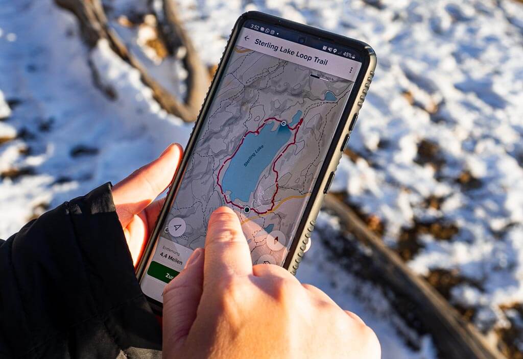
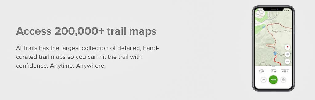
1. AllTrails
Download: iOS I Android
Website: alltrails.com
Price: Free & Paid ($29.99/year)
AllTrails is probably the most widely known hiking app out there. When you search for a hike online, you can be sure AllTrails will be in the top 3 results. According to us and many others, it is the most user-friendly app and website to use. AllTrails has without a doubt made our hiking experiences more enjoyable.
Not all features are included in the free version but since we do a lot of hiking, it was a no-brainer for us to purchase the AllTrails Pro version to have access to all the greatest perks. We would highly recommend upgrading your subscription right away.
Our highlight of the Pro version is the possibility to download maps and use them offline when you don’t have service. We can’t even count how often the offline map saved us from completely getting lost, especially when hiking in more secluded areas or trying to find hidden caves, like Soldier’s Pass Cave in Sedona.
AllTrails Hiking App Features:
- Finding hiking trails (near you)
- Saving and creating list of hiking trails
- Viewing trail information (length, elevation, trailhead, difficulty)
- Search for hikes by certain criteria and location
- Record hikes
- Download trail maps for offline use
2. Gaia GPS
Download: iOS I Android
Website: gaiagps.com
Price: Free & Paid ($40.00/year)
Quite similar to AllTrails, Gaia GPS is definitely worth consideration for finding the best hiking GPS app for you. Since there is a free version of the app, we have created an account and will use it occasionally.
Gaia GPS gives you all the information about the trail itself, like distance, ascent, type, and estimated time, but also provides you with other trails nearby if you can’t stop exploring the beautiful landscapes.
Top Tip: To get access to all of the features listed below, you need to purchase the annual membership.
Gaia GPS Hiking App Features:
- GPS online & offline
- Find new hiking trails
- Save hiking details
- Download offline maps
- Print maps
- Record hiking route
- Exclusive hiking trail map catalog
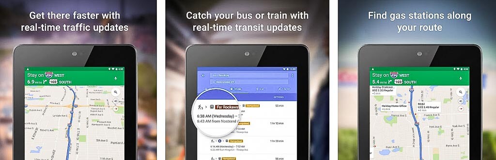
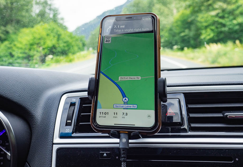
3. Google Maps
Download: iOS I Android
Website: google.com/maps
Price: Free
Google Maps is one of the best free hiking apps, especially since most smartphone users already have it installed on their phones.
One thing we like about using Google Maps is it mostly does a great job leading us to the trailhead to start our actual hike. You can even download free offline maps to find your location. These maps are not as complex as other apps for hiking. But it is still nice to have a backup map of the area.
On top of that, you can create your own maps with the best hikes in an area of your choice. We designed our own New York State hiking map to always find the best trails near us, even when we are traveling.
Google Maps App Features:
- View and Add trail photos
- Download offline maps (in advance)
- Save points on a map
- Search hiking trails
- View trail in satellite mode to gauge difficulty
4. Spyglass
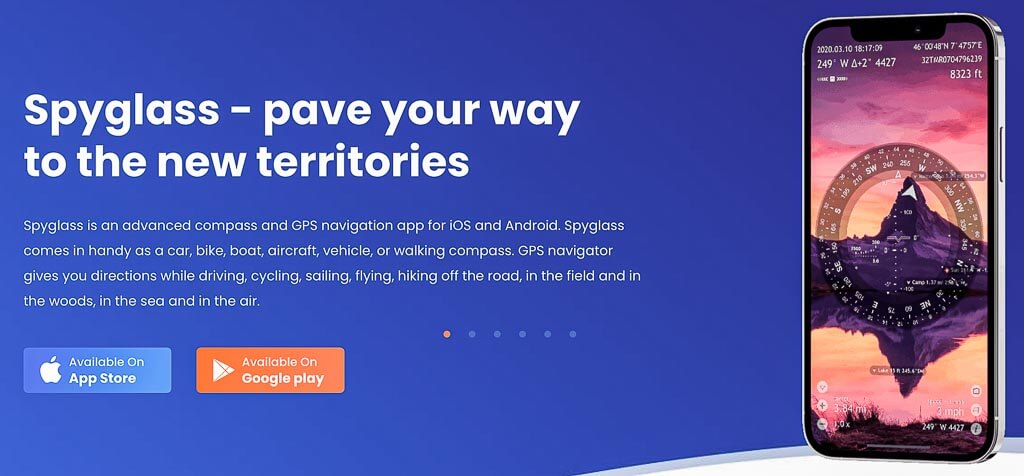
Download: iOS I Android
Website: spyglassnav.com
Price: $5.99
Spyglass is by far the most advanced GPS navigation app on the list. It is a gem for outdoor lovers who want to learn more about how to use the sun, moon, and stars to navigate, and how to track wildlife. Overall, you will get excellent navigation toolkits for survival in the wild.
This being said, it would probably take most users a good amount of time to become familiar with all the app’s high-tech features. The website offers quick explanation videos to make learning them easier.
If you are not interested in the in-depth navigation perks this app has, we would stick to another best app for hiking trails which is more basic.
Spyglass App Features:
- Military grade digital compass
- Rangefinder to track distances
- Uses augmented reality display
- Save data from your hike for future reference
- Tactical GPS tool
5. Hiking Project
Download: iOS I Android
Website: hikingproject.com
Price: Free
This hiking app is great if you are looking for new trails or inspiration on where to go hiking next. We like to use this app to find out more about the trails we are interested in.
Hiking Project is one of the best apps for hiking trails but not our go-to app in regards to unique hiking features. The perk we like the most is the trail rankings by popularity which can help determine if you think exploring a certain trail is worth it or not.
We like to use this app occasionally because sometimes we get different information we didn’t find on our other apps. That makes it a good backup to AllTrails.
Hiking Project Hiking App Features:
- Search and save trails
- Detailed trail information and descriptions
- Trail guides
- Photos of the trails
- Navigation and tracking
- Read trail users comments
6. FarOut (Formerly Guthook Guides)

Download: iOS I Android
Website: faroutguides.com
Price: In-app purchase for guides (prices vary depending on the guide)
Are you a long-distance hiker or backpacker? Then you probably already know about this popular detailed hiking guide app from all over the world. It is one of the best apps for hikers heading out to complete the Pacific Crest Trail, Appalachian Trail, or John Muir Trail.
This trail map app provides the most dependable offline maps for long hikes. The app itself is free but you will have to pay some dollars to purchase the specific hiking guides. Prices range from $3.99 – $59.99 depending on the style and length of the hike. It is a small price to pay though for all the in-depth trail information you get.
You will be able to find the distance, elevation, and waypoints but also important information about water sources and campsites on this best GPS app for hiking. You also have access to topographic and satellite maps.
FarOut App Features:
- Trail guides
- Dependable trail data
- Works offline
- Detailed waypoints along the trails with elevation, photos, and descriptions
- Read other trail users comments
- Individualized route planning based on campsite, water source, or point of interest
7. FATMAP

Download: iOS I Android
Website: fatmap.com
Price: In-app purchases
FATMAP is an app for outdoor enthusiasts who love the mountains. It is primarily focused on backcountry skiing, snowboarding, and biking.
Although not a primarily hiking app, we thought we would throw this one on the list as an added bonus since many hikers also like skiing, snowboarding, and biking.
This app shows you more than just the trails themselves, it gives you detailed information about the terrain to make planning your activity as easy as pie. To get inspired, you can check out trips people around you accomplished and you can even record your own adventure to share it with friends.
FATMAP App Features:
- Great for skiing adventures, hiking, and biking
- Tracks ski lifts, snow depth, and snow forecast
- Download offline maps to use anywhere
- 3D maps
- Track and record your adventures
- Find new adventures
8. Cairn
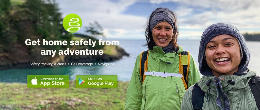
Download: iOS I Android
Website: cairnme.com
Price: Free & Paid ($26.99/year)
The Cairn is a great safety-focused hike tracking app. What makes it one of the best apps for hikers is the safety tracking and alert, and the finding cell coverage feature. It also supports hikers staying on track with a useful navigation tool.
If you plan on hiking in areas with limited to no cell service (which is most likely the case), you may want to think about upgrading to the paid version of Cairn to find cell coverage on the trail and stay in contact with your loved ones. In case of an emergency, they will also be able to track your location and send a search and rescue team.
Top Tip: Especially when you hike solo, this app can save you a lot of headaches, knowing that your family or friends can always track where you are.
Cairn Hiking App Features:
- Share hiking plans
- Trail alerts
- Real time location tracking
- See statistics while hiking including estimated time of arrival
- Find locations with cell service
- Download offline maps
- Record hiking trails
9. Peak Visor
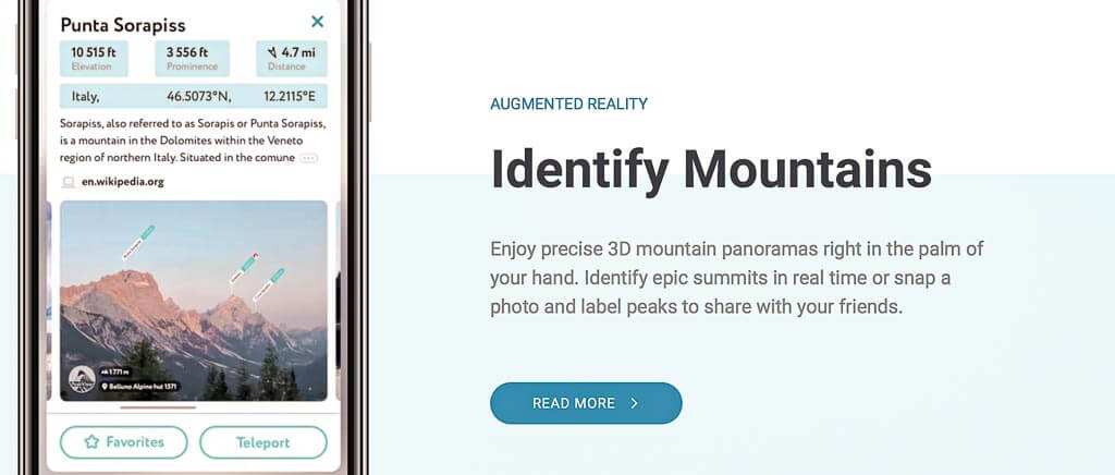
Download: iOS I Android
Website: peakvisor.com
Price: Free & Paid ($29.99/year)
Ever been on a hike and wondered what mountains were off in the distance? Well, then this may be the app for hiking you are looking for. By pointing your phone’s camera at the mountains, the app will instantly solve your curiosity by telling you the names.
The app’s augmented reality feature works in real-time as well for past photos you have taken. The Peak Visor database has nearly 1 million mountains worldwide, so it is pretty likely it will be able to tell you the mountain name you are wondering about.
If you are really interested in discovering mountain names, it would be best to upgrade to the paid version of the app. The free version only works when you have cell service, whereas you can utilize the paid version wherever your adventure takes you.
Peak Visor App Features:
- Identify mountains using augmented reality through your camera
- Plan hikes with satellite 3D maps
- Tag mountains in photos
- Teleport to any location to explore in a 3D world
- Offline capabilities
- Custom trails
- Professional photography tools
10. Peak Finder
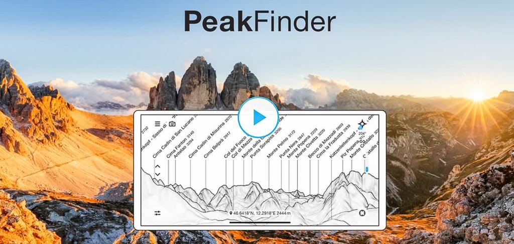
Download: iOS I Android
Website: peakfinder.org
Price: $4.99
If the mountains are calling, then download Peak Finder. Peak Finder is very similar to the above Peak Visor app. Both hiking apps help identify nearby mountains. It is pretty incredible how it is able to pinpoint the name of the exact mountain you are looking at.
In comparison to the Peak Visor app, we find the Peak Finder website slightly more complicated to use. Also, Peak Visor offers almost all of the features for free whereas this app doesn’t provide a free version.
Peak Finder App Features:
- 360 degree panoramic view
- Current location
- Camera mode to overlay an image with panorama drawing
- Snapshot of your panoramic view and edit with mountain names
- View list of visible peaks in your current location
- Telescope feature to find less prominent mountains
11. Skyview Lite

Download: iOS I Android
Website: Not Available
Price: Free
Skyview Lite app is the perfect app for night sky lovers and stargazers. This app helps outdoor lovers identify planets, stars, constellations, and satellites.
It is a very simple and user-friendly app. To start admiring the night sky, just open Skylite View and point your phone to a spot in the sky you would like to discover. The app uses augmented reality to quickly identify what you are looking at. You don’t even need wifi to make a connection to what is going on around you.
Skyview Lite App Features:
- Identify galaxies, stars, constellations, and satellites passing overhead at your location
- Set reminders for stargazing events
- Augmented reality to spot objects in the sky, day or night
- Jump time to see the sky at different days and times
- Follow the sun and moon paths
12. Star Walk
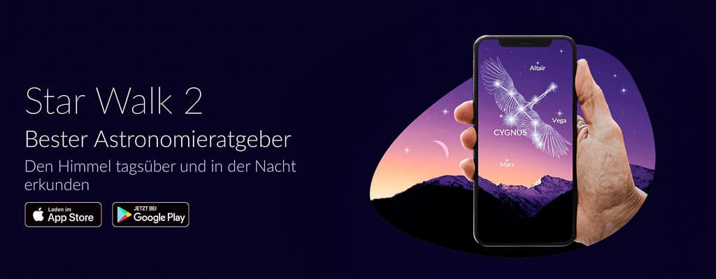
Download: iOS I Android
Website: starwalk.space
Price: $0.99 (In-app purchases)
Star Walk is another night sky and stargazing app for hiking and outdoor lovers. It provides a sky map in real-time including all kinds of sky objects all within the palm of your hand. It also notifies you of the best astronomical events, so that you don’t miss anything spectacular anymore.
This app is ranked as the ‘Best Astronomy Guide’ due to its ability to get additional information and facts on the sky objects you are gazing at.
Star Walk App Features:
- Real time interactive sky map
- View sky objects that are visible from your location
- Encyclopedia of the sky: learn facts about the sky’s objects
- Stay informed on astronomical news
13. Seek by iNaturalist

Download: iOS I Android
Website: inaturalist.org
Price: Free
Seek is a pretty unique app for nature enthusiasts. It is the perfect hiking app for people who enjoy learning about the nature around them. This app allows you to quickly and effortlessly identify wildlife, plants, and fungi along the hiking trails.
There have been many times we have been on the trails wondering what type of plant or animal is next to us. While hiking in upstate New York we frequently see snakes and try to google them after our hiking adventure is over.
This app saves us so much research time and is super easy to use. Simply take a photo and Seek will give you a list of potential plants or animals you could have seen.
Seek App Features:
- Identify wildlife, plants, and fungi
- Learn more about the outdoors around you
- Participate in monthly observation challenges
14. National Park Service (NPS) App
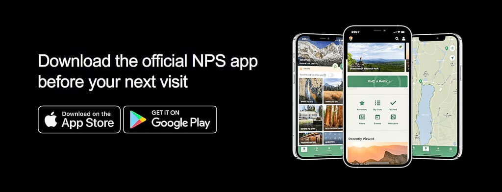
Download: iOS I Android
Website: nps.gov
Price: Free
We were so happy when we finally realized there was an app just for the National Park Service. Being National Park geeks and travelers, we love the wealth of information this app provides for each park.
This hiking app is not as technologically advanced as the other hiking apps on this list and it is not the best GPS hiking app for trails at all. But it does provide tons of information.
The National Park Service app is a one-stop shop for everything you need to know about visiting National Park sites. You can find updated park information like openings and closures, basic information like address and fees, best things to do, amenities, and more.
Our favorite feature is the best hikes in specific parks. Here you can quickly find a brief description of the hike itself, duration, fee, location, the best time of year to hike the trail, and if a reservation is needed. This is a dream app for National Park hiking trails.
NPS App Features:
- Trail status
- Detailed trail description and information
- Extensive National Park and site information
- Hiking, tour, reservation, activities, and accommodation information
15. Recreation.gov

Download: iOS I Android
Website: recreation.gov
Price: Free
This is the ultimate app for outdoorsy people who love to recreate in federally operated public lands around the United States.
Most people know this app for booking campsites, especially in the U.S. National Parks, but it has much more to offer. Through the app or website, you can book permits, tours, shuttle tickets, passes, and get additional information on different destinations and activities.
Top Tip: If you are not really an app person or prefer working on a bigger screen, we would recommend utilizing their great services on their website. We frequently book our trips with Recreation.gov on their website.
Recreation.gov App Features:
- Reserve campgrounds and tickets
- Purchase permits for wilderness access
- Join the lottery system for certain park activities
- Book Ranger tours
- Get Interagency passes
- Explore destinations and activities
- Find inspiration and information to plan your next adventure
Overview of Best Apps for Hiking
These are the best apps for hikers in the different categories:
- Overall Hiking App: AllTrails
- GPS Hiking App: Spyglass
- Advanced Hiking App: Spyglass
- Inspirational Hiking App: Hiking Project
- Most User Friendly Apps for Hiking: Google Maps and AllTrails
- Safety Focused Hiking App: Cairn
- Unique Apps for Hiking: Peak Visor
- Basic Hiking Apps for Apple Watch: Apple Watch Activity
Frequently Asked Questions about Hiking Apps
Does Google Maps show hiking trails?
Yes, Google Maps does show hiking trails. To spot hiking trails on Google Maps, you will want to look for dotted green lines which indicate a trail.
However, Google Maps is not the best app for hiking trails. It is only reliable in showing the more popular trails. If you are looking for a less desirable trail, you are better off using an alternative app for hiking mentioned above. We would personally recommend using AllTrails.
Can I use my phone GPS for hiking?
Yes, using your phone GPS for hiking is a great way to stay on the trails. Most of the hiking apps used on your smartphone utilize your phone’s GPS to show real-time location.
How do I download offline trail maps?
Usually, to download offline trail maps you will need to pay for a subscription to one of the hiking apps. The download process might differ on the various apps.
To download an offline map on AllTrails, you will want to open the app, find the desired hiking trail, click on it, tap on the download button, choose which type of offline map you want, and wait for it to download. Once it is downloaded, you can open it at any time.
We recommend downloading the offline map ahead of time, while you still have service.
What are the best free hiking apps?
The following hiking apps free, give you the most detailed information about the trail, and/ or the area you are hiking in:
- AllTrails
- Gaia GPS
- National Park Service
Some of these free apps offer pro versions for a few bucks. If you are a frequent hiker, it is well worth it to invest your money to get access to all of the features the app provides.
What is the best GPS app for hiking?
This is a difficult debate, but we would have to say it would depend on the user. We prefer to use AllTrails for our GPS app for hiking, while many others prefer to use Gaia GPS. Ultimately, they are both the best hiking GPS apps with slightly different features and prices.
What is your Favorite Hiking App? Which Feature do You Use the Most?
Let us know in the comments below!
Other Resources for Hiking
- 33 Most Beautiful Trails for Hiking in Hudson Valley
- 34 Top Rated Best Hikes Upstate New York
- 57 Spectacular Waterfalls in NY You Have to See
- 13 Most Scenic Minnewaska State Park Trails
- What You Should be Packing for a Hike: The Essentials + Extras
- 100+ Best Gifts for Hikers to Buy
You Might Also Like
- National Parks: First Hand Ranking of National Parks in the U.S. from Best to Worst
- National Park Pass: How to Save Money with the America the Beautiful Pass
- Quotes: 100+ Best Hiking Quotes to Inspire Your Future Adventures
Save this Post for later on Pinterest!
Did you like this post? Subscribe to our newsletter and we’ll send you more unique travel tips, updates, and even FREE content!