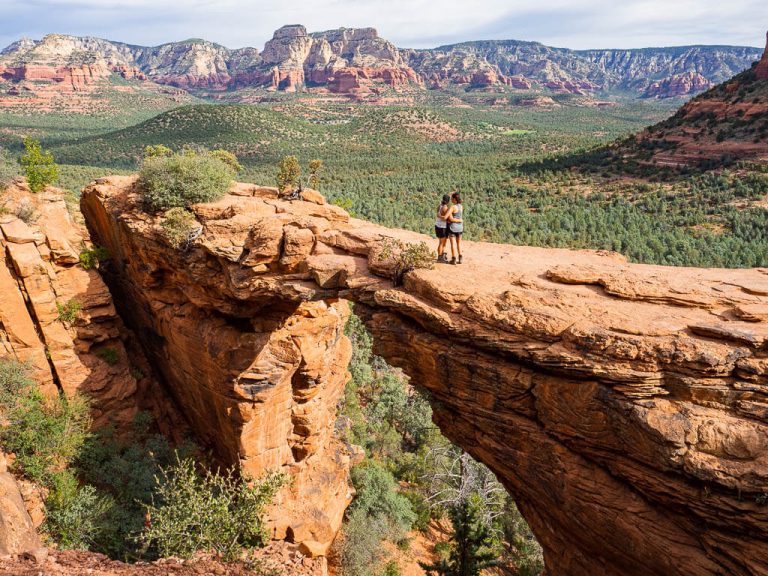
34 Best West Coast National Parks + Western U.S. Parks that Will Blow Your Mind
The western states of the USA attract millions of visitors every year. Most of the breathtaking landmarks can be found in the west coast national parks.
The west coast national parks are home to a variety of different landscapes from majestic mountain ranges, to turquoise alpine lakes, vast desert landscapes, and tropical forests. We could continue listing more and more stunning features but we truly can’t do its justice.
Here you will find inspiration and detailed planning tips for your next west coast national parks adventure. Read more about quick facts, the best things to do, individual tips to visit, a suggested itinerary, and the best time to plan your trip to each national park on the west coast.
Other National Park Resources:
- 16 Best East Coast National Parks You Need to Visit
- First-Hand Ranking of National Parks in the U.S. from Best to Worst
- A Complete National Park List by State + Downloadable Checklist and Map
This post may contain affiliate links. If you make a purchase through them, we get a small commission at no extra cost to you. It helps us create free content for you to enjoy. Learn more about our disclaimer here. Thanks for your support!
America the Beautiful Pass
When visiting a lot of National Parks, the America the Beautiful Pass is the best purchase we can think of. It will save you big bucks.
For only $80 it gives you unlimited access to all of the more than 2,000 National Park sites for one whole year, the breathtaking east coast national parks and west coast national parks included. Too good to be true?!
Check out our detailed post about the America the Beautiful pass to get to know all the perks before visiting the west coast national parks.
Read More: How to Save Money with the America the Beautiful Pass
Where is the “West Coast” in the U.S?
Technically, the “US west coast” refers to the states along the Pacific coastline.
There are 5 states which sit along the west coast with shorelines on the Pacific Ocean. Here is a list of those states from north to south:
- Alaska
- Washington
- Oregon
- California
- Hawaii
How many National Parks are there on the West Coast?
West Coast National Parks Map
There are 24 west coast national parks located directly on the west coast. However, our post also includes 10 more west coast national parks in western United States. That makes a total of 34 west coast national parks we cover in this post.
The western states consist of 12 states. Besides the 5 states with shorelines on the Pacific Ocean, there are 7 more states in the west: Arizona, Idaho, Montana, Nevada, New Mexico, Utah, and Wyoming.
These are the national parks in the western United States we added which are not directly located on the west coast:
- Yellowstone National Park – Wyoming
- Grand Teton National Park – Wyoming
- Zion National Park – Utah
- Bryce Canyon National Park – Utah
- Arches National Park – Utah
- Canyonlands National Park – Utah
- Capitol Reef National Park – Utah
- Rocky Mountain National Park – Colorado
- Great Sand Dunes National Park – Colorado
- Grand Canyon National Park – Arizona
If you are specifically looking for National Park Service sites, along the west coast, check out this complete list of all the NPS sites in the United States you can choose to visit. Here you will see all the National Parks of the west and more.
Best National Parks on the West Coast
It’s time to dive deeper into the 24 national parks on the west coast. Besides getting some inspiration on where to go next, get to know the most important information for your visit to west coast national parks.
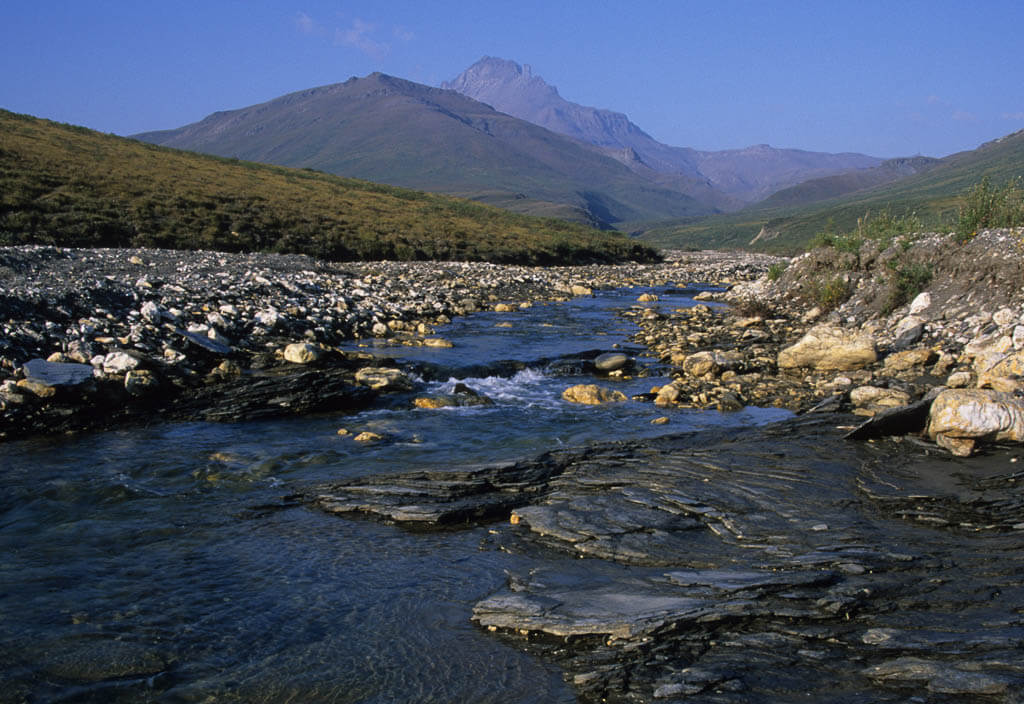
Gates of the Arctic National Park and Preserve
Location: Alaska
Suggested Stay: 1-5 days
Entrance Fee: Free
Highlights: Undeveloped wilderness, Arctic climate
Fun Fact: Gates of the Arctic is the least visited National Park in the United States.
Closest Airport: Fairbanks International Airport (FAI)
Gates of the Arctic National Park and Preserve Official Website
Gates of the Arctic National Park lies above the Arctic circle. It is the second-largest park and the northernmost park in the USA which encompasses 8,472,506 acres. The park preserves the vast, wild, and undeveloped land of Alaska’s central Brooks Range. There are no designated hiking trails, nor designated campsites in the park.
There are also no roads in or out of the park which makes this a difficult west coast national parks destination to visit. Travelers who want to enjoy this west coast park must schedule a flight. Because of its hard to get to location and high travel costs, it is one of the least visited national parks in the US with an average of 50 visitors a day.
Best Things to Do
- Hike the Anaktuvuk Pass to the Dalton Highway – This 65-mile trek through the Brooks Range is an adventure of a lifetime. Pass snow-covered mountain peaks and get close to the Alaskan wildlife.
- Canoe on the Noatak River – Floating the waters is one of the best ways to get access to some of the best locations in Gates of the Arctic.
- Climb the Arrigetch Peaks – Experienced, technical climbers can get high up on the Arrigetch Peaks to enjoy stunning views of the vast land.
What to Know Before Visiting Gates of the Arctic National Park
- Only backpack the national park on your own when you are a skilled backcountry adventurer. We would suggest exploring this park on a guided multi-day tour.
- Only go for the day. If you can’t afford a multi-day tour, book a flightseeing tour or an unguided day trip from Fairbanks instead. During your day trip, you will be able to hike and paddle the waters.
- The arctic weather can change quickly. It always poses challenges like thunderstorms, wildfires, flash floods, and freezing temperatures. Pack accordingly.
- Gates of the Arctic receive continuous sunlight for at least 30 days in the summer. That will give you a lot of time to explore!
- Visit the Visitor Centers to learn about advisories and safety updates.
Gates of the Arctic National Park Suggested Itinerary
Your itinerary for this west coast national park depends on the guided multi-day trip or day trip you have booked or the backcountry trip you have planned.
When to Visit
The long, freezing winters make it almost impossible to stay at the Gates of the Arctic National Park.
By far the best time to visit is in the summer, from Mid June to September. Then the flowers are blooming, and wildlife like bears, wolves, moose, and Dall sheep is abundant.
Since July through September are the wettest months of the year, it is the best time for some excellent float trips on the river.
Where to Stay
Camping – There are no designated campsites in Gates of the Arctic
Kobuk Valley National Park
Location: Alaska
Suggested Stay: 1-5 days
Entrance Fee: Free
Highlights: Wilderness, wildlife (Caribou), Kobuk River, Great Kobuk Sand Dunes, Little Kobuk, and Hunt River dunes
Fun Fact: Kobuk Valley National Park is located 25 miles north of the Arctic Circle, joining Gates of the Arctic National Park as the only two U.S. national parks north of that line.
Closest Airport: Fairbanks International Airport (FAI)
Kobuk Valley National Park Official Website
Kobuk Valley National Park is not accessible by car, like many of the Alaskan National Parks on the west coast. You can get there by foot, plane, or boat.
It is best known for the Great Kobuk Sand Dunes which is the largest arctic dune field in North America. The sand which created the dunes has been carried by the grinding action of the glaciers, wind, and water.
To see the park’s wildlife, travel along the Kobuk River to catch the Caribou migrating to the north in the spring and south in the fall.
Best Things to Do
- Plan a Backpacking Trip – Make your own way through the sand, tundra, patches of forest, and up to the mountains on a unique backpacking trip far away from civilization.
- Book a Flightseeing Tour – A great way of getting a glimpse of Kobuk Valley is to book a flightseeing tour out of Kotzebue or Bettles. Most of the companies will land in the national park for some quick photo opportunities. A lot of people like to combine a Kobuk Valley flightseeing tour with a flight over the Gates of the Arctic.
- Paddle the Rivers – The Kobuk River is a slow-moving river that can be best explored in a collapsible canoe or kayak. You would have to bring your own boat or book a tour.
- Explore the Great Kobuk Sand Dunes – The sand dunes are the crown jewel of the park, especially in the fall when the caribou are migrating. Keep in mind that the temperature at the dunes can get quite hot at 100 degrees in the summer.
- Go Fishing – There is plenty of fish for you to catch, like Sheefish, salmon, grayling, pike, and Dolly Varden. Make sure to only fish what you actually eat to keep the ecosystem healthy.
What to Know Before Visiting Kobuk Valley National Park
- The terrain is very challenging. There are also no trails, so you need some orienteering skills when backpacking in Kobuk Valley National Park.
- Weather can change rapidly. Bring warm clothes and lots of layers, a breathable rain jacket and rain pants may come in handy.
- Don’t bring animal-resistant containers. They can be borrowed for your camping trip at the Northwest Arctic Heritage Center in Kotzebue.
Kobuk Valley National Park Suggested Itinerary
It really depends on how many days you stay in Kobuk Valley, which part of the park you will explore, and your plans for what to do to make a specific itinerary for this west coast national park.
When to Visit
To experience summer-like weather with an average temperature of 50 degrees F you have to travel to Kobuk Valley from early June to mid-August. Even in those months, you can have freezing temperatures.
The fall (mid-August to mid-October) has fewer mosquitos and offers beautiful fall colors but is significantly cooler with an average temperature of 35 degrees F.
Where to Stay
Camping – There are no designated campsites but the most popular destinations for camping are the Great Kobuk Sand Dunes and Onion Portage.
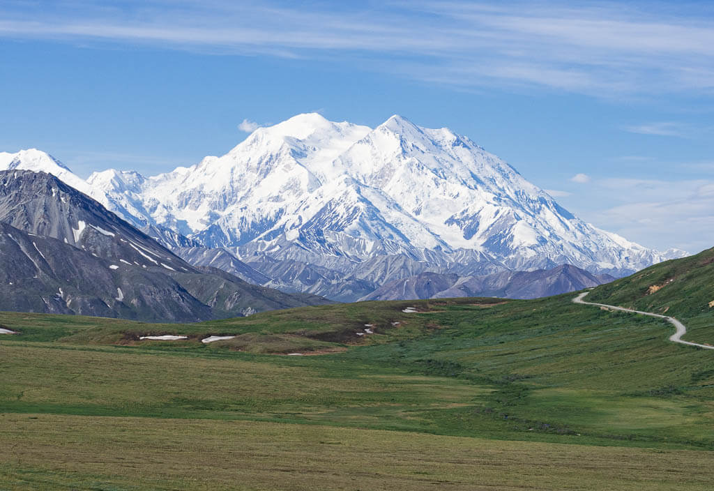
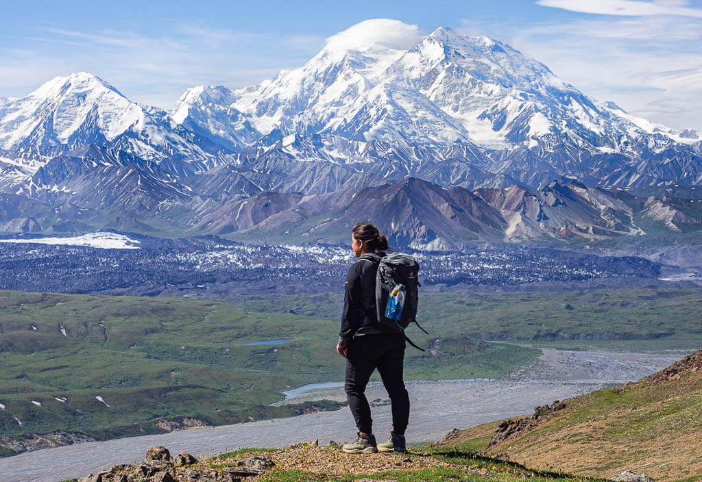
Denali National Park
Location: Alaska
Suggested Stay: 3 days
Entrance Fee: $15 per person (valid for 7 days)
Highlights: Denali (Mt. Mckinley), wildlife, Denali kennels
Fun Fact: Mount McKinley is the highest point on the North American continent.
Closest Airport: Fairbanks International Airport (FAI)
Denali National Park Official Website
Denali National Park is known for the tallest mountain in North America, Denali formerly Mt Mckinley. This was the first park to be established as a National Park solely to protect wildlife such as the grizzly bear, Dall sheep, wolves, and moose.
The best way to see the west coast national park is on the ranger-led shuttle since the park is closed off to vehicles after 15 miles on Denali Park Road.
If you are making a trip to Alaska, this is a must see west coast national park.
Best Things to Do
- Take a Park Tour on Denali Park Road – See past Mile 15 on a Denali Bus Tour. You can choose a narrative or non-narrative tour. The tour will last about 4 to 5 hours depending on which one you pick.
- See Denali from above on a Flightseeing Tour – You can choose from a variety of flightseeing tours offered in Denali National Park and even land on a glacier. Make sure you are booking with an approved company.
- Hike the Trails
- Savage River Loop (2.1 miles, easy)
- Horseshoe Lake Trail (2.1 miles, easy)
- Thorofare Ridge Trail (2.2 miles, strenuous)
- Savage Alpine Trail (4.1 miles, strenuous)
- Triple Lakes Trail (18.5 miles, strenuous)
- Visit the Denali Kennel – Visit the sled dogs of Denali Kennel. Learn more about what they do while enjoying some snuggles from the dogs.
- Spot the Big Five – Caribou, Dall Sheep, Grizzly Bears, Moose, Wolves
What to Know Before Visiting Denali National Park
- Take a bus to explore the backcountry. You can only drive the first 15 miles into the park on Denali Park Road. From Savage River Check Station, you must either take a bus, bicycle or hike in. Most people choose to take the shuttle bus or interpretive bus tour. Buy bus tickets way in advance, they sell out quickly.
- Mt Mckinley and Denali are the same mountain. It was renamed Denali in 2015.
- You have to be lucky to see the mountain. Only about 30% of people actually get to see Denali. Most of the time the mountain is hidden by the clouds.
- Flightseeing Tours get canceled frequently due to unstable weather conditions. If possible try to be flexible to fly out another day. Most flightseeing companies give you a ‘No weather worries’ guarantee to modify, or reschedule your flight or get a 100% refund.
Denali National Park Suggested Itinerary
DAY 1: Join a bus tour to go out to Eielson Visitor Center at mile 66 on Denali Park Road, and hike up Thorofare Ridge Trail.
DAY 2: Visit the Denali Kennels, hike Horseshoe Lake Trail, Drive the first 15 miles of Denali Park Road, and hike Savage River Loop and/or Savage Alpine Trail.
DAY 3: Take a flightseeing tour of Denali
When to Visit
The best time to visit Denali National Park is from May 20 to the middle of September. During this main season, bus tours are being offered. This is also the best time to spot wildlife, because the weather is mild, and there is an abundance of daylight.
Where to Stay
Camping – Riley Creek Campground (NPS) / Wonder Lake Campground (NPS)
Budget – Denali Park Hotel
Midrange – McKinley Chalet Resort
Lake Clark National Park and Preserve
Location: Alaska
Suggested Stay: 3-5 days
Entrance Fee: Free
Highlights: Lake Clark, Kontrashibuna Lake, rivers, mountains, wildlife
Fun Fact: Lake Clark protects over 4 million acres of wilderness ranging from sea level to 10,000 feet in elevation.
Closest Airport: Port Alsworth Airport (PALJ)
Lake Clark National Park and Preserve Official Website
Lake Clark National Park is a remote destination that requires a 1-hour small plane ride from Anchorage to Port Alsworth. This plane ride alone is absolutely worth the visit. You will fly over majestic snow-capped mountains, massive fields, and the turquoise, crystal-clear Lake Clark.
Port Alsworth is a small village with a population of 135 people. It is a great base to explore some of the west coast national parks’ gems. Go hiking and backpacking in the surrounding area, catch gorgeous waterfalls, paddle the stunning Lake Clark, or take day trips to other spectacular areas of the national park.
Best Things to Do
- Backpack at Kontrashibuna Lake – Admire the impressive Tanalian Falls before you get to your destination for the night, Kontrashibuna Lake. Take the Beaver Pond Loop Trail on your way back to Port Alsworth.
- Tackle the Tanalian Mountain Trail – Hike the strenuous 8.6 miles round trip up the mountain for breathtaking views of Lake Clark National Park from above. Try to spot the sheep at the summit.
- Visit Twin Lakes – Take a floatplane to get to this crystal clear lake and check out the Proenneke Cabin, a real Alaskan bush log cabin that is on the National Register of Historic Places.
- Kayak on Lake Clark – Rent kayaks and cruise around Lake Clark for the day or even spend the night along the beautiful shores.
- Go Bear Viewing – There are several spots where you can see bears: Chinitna Bay, Crescent Lake, Silver Salmon Creek, Shelter Creek, and Tuxedni Bay. They all require a journey with a small plane to get there.
What to Know Before Visiting Lake Clark National Park
- Take a small plane to get there. Lake Clark National Park is only reachable via a small plane that flies from Anchorage.
- Take everything in and out with you. If you are not staying in the Farm Lodge, you have to pack everything you will need for your stay. Resources are limited in the park. There is no grocery store, only a food truck that can provide you with a tasty meal.
- Save some money. A trip to Lake Clark National Park is not cheap. You can save some bucks when you decide to camp, otherwise, you will have to pay a decent amount of money for accommodation.
- Animal-resistant containers can be found next to the lake. If you are looking to backpack to Kontrashibuna Lake, you don’t have to bring your own animal-resistant containers. You will find bear-proof metal storage lockers in certain spots along the lake.
- Borrow a canoe for free. Along Kontrashibuna Lake you can also find some canoes you can borrow to paddle the waters.
- Bring insect repellent and a mosquito hat. We’ve never experienced so many annoying bugs. I don’t know how we would have survived without wearing our mosquito hats.
Lake Clark National Park Suggested Itinerary
DAY 1: Arrive at Port Alsworth via a small plane from Anchorage. Visit the Visitor Center before you start your hike to Tanalian Falls and Kontrashibuna Lake. Spend the night camping at the lake.
DAY 2: Hike back to Port Alsworth and get your kayak to paddle Lake Clark. Float along Lake Clark and find a nice spot to camp along the shore.
DAY 3: Explore the only maintained trail in Lake Clark out of Port Alsworth, the Portage Creek Trail. Spend the night at a rustic log cabin (Joe Thompson or Priest Rock Public Use Cabin)
DAY 4: Wait for your water taxi to pick you up to get back to Port Alsworth.
DAY 5: If you are up for a strenuous day hike, tackle the steep Tanalian Mountain or book a tour to Crescent Lake or Twin Lakes.
When to Visit
In July, August, and September you will mainly have warm, sunny weather. During that time, wildlife, especially bears, are more active. When you are lucky you can even spot some females with their cubs.
Keep in mind that Alaskan weather is always unpredictable, so plan accordingly and bring warm layers and rain gear.
Where to Stay
Camping – Kontrashibuna Lake (Backpacking) / Campground Tulchina Adventures
Budget – Tanalian Rental Cabin
Midrange – The Farm Lodge
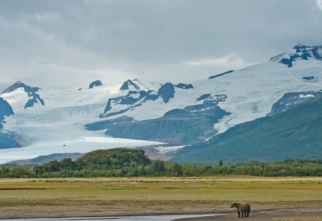
Katmai National Park and Preserve
Location: Alaska
Suggested Stay: 3 days
Entrance Fee: Free
Highlights: Bears, Mount Katmai, Valley of Ten Thousand Smokes, remote wilderness
Fun Fact: The Katmai area is home to about 2,000 grizzly, or brown bears, the largest concentration known.
Closest Airport: King Salmon (AKN)
Katmai National Park and Preserve Official Website
There is no better place in the United States to catch a glimpse of brown bears than Katmai National Park. A major highlight of the park is watching brown bears feeding on migrating salmon on Brook Falls during the summer. This can be safely done from viewing platforms.
Originally this west coast national park was created to preserve the Valley of Ten Thousand Smokes, which is a forty square mile, 100 to 700-foot deep ash flow deposited by Novarupta Volcano.
Best Things to Do
- Bear Watching – Technically, you can see bears everywhere in Katmai National Park but the easiest way to spot them is from the viewing platforms at Brook Falls from July to September when the bears fish for salmon in the falls.
- Go for a Hike – The easy and quick 1.2-mile round trip Brooks Falls trail is a can’t miss because it will lead you to the viewing platforms to watch the bears fishing. If you are up for a moderate 3-mile out-and-back hike up a mountain with beautiful vistas of Brooks Camp and Naknek Lake from above, take the Dumpling Mountain trail.
- Explore Naknek Lake – Go fishing or kayaking on the largest lake in the US which is fully located within a national park. The shoreline is also a great spot to watch bears.
- Book a Trip to the Valley of Ten Thousand Smokes – This valley of ash and wasteland is a product of the largest volcanic eruption in the 20th century. Book a day trip to admire the bare landscape from some viewpoints and a hike.
- See the Park from above – Get the first impression of Katmai National Park, its size, and diverse landscape of river valleys, volcanoes, and mountain peaks, on a flightseeing tour from Anchorage, Homer, King Salmon, or Katmai National Park.
- Go Fishing – Katmai National Park attracts sports fishers from all over the world due to the variety of fish, like rainbow trout, dolly varden, and five species of salmon.
What to Know Before Visiting Katmai National Park
- Stay overnight. You can visit Katmai National Park on a day trip from Anchorage, Kodiak, or Homer but we would highly recommend spending a night or two at Katmai to have more time to fully enjoy watching the bears feeding on salmon.
- Go bear viewing in the early morning and after 4 PM. Between 10 AM and 4 PM, the viewing platforms are busy with the day-trippers. Just a certain number of people are allowed on the viewing platform. During the day it fills up quickly and you have to expect to wait a while to get your turn.
- Remember bear safety: Keep your distance, travel in groups, and be noisy.
Katmai National Park Suggested Itinerary
DAY 1: Arrive in the park, climb up Dumpling Mountain and watch the bears catching the salmon.
DAY 2: Day trip to the Valley of Ten Thousand Smokes, bear viewing
DAY 3: More bear viewing (you can simply don’t get enough of it) before you leave Katmai National Park.
When to Visit
The absolute best time to visit the park to see the brown bears catching the salmon at Brooks Falls is from the middle to the end of July. The bears usually arrive at Brooks Falls at the end of June, and the salmon also show up by the end of June, and the beginning of July. Their arrival can be delayed due to late snowstorms, a lot of rain, and colder temperatures.
To be on the safe side, plan on visiting later in July.
Where to Stay
Camping – Brooks Camp
Midrange – Brooks Lodge (You have to enter a lottery to book a room)
Kenai Fjords National Park
Location: Alaska
Suggested Stay: 2-3 days
Entrance Fee: Free
Highlights: Glaciers, sea wildlife
Fun Fact: 51% of the land in Kenai Fjords National Park is covered by ice.
Closest Airport: Anchorage International Airport (ANC)
Kenai Fjords National Park Official Website
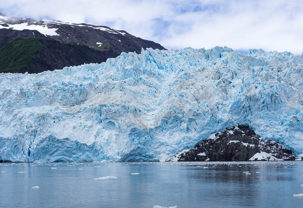
Kenai Fjords National Park may be Alaska’s smallest National Park but it is still big in comparison to many of the parks in the lower 48. The park is situated on the southeast coast of the Alaskan Kenai Peninsula.
The crown jewel of west coast park is the Harding Icefield which can be explored on a strenuous hiking trail. It is the largest icefield that lies entirely within the United State borders.
Besides taking an exhausting climb, cruise on a boat tour to explore the park’s waters, more glaciers, and marine life like puffins, sea lions, whales, and otters.
This is one of our top west coast national parks to visit.
Best Things to Do
- Trek the Harding Icefield trail – The Harding Icefield is a strenuous 8.2-mile out-and-back hike with an elevation gain of more than 3,500 ft. If you can’t tackle the whole trail, try to make it to the impressive Top of the Cliffs viewpoint and then turn around. However, we highly suggest trying to complete the entire trail which takes about 6-8 hours for breathtaking vistas of the massive icefield from atop.
- Hike to Exit Glacier – Hike the short network of trails to explore Exit Glacier via the Exit Glacier Overlook. Even when you explored the Harding Icefield before, it is well worth it to add this short hike to your itinerary to see the glacier from a different perspective.
- Take a boat tour – Choose one of the Kenai Fjords National Park Cruises to explore the glaciers, and sea life of Kenai Fjords out of Seward, Alaska.
- Go Ice Climbing on Exit Glacier – Ready for a more in-depth glacier experience? Then step out and walk and climb on Exit Glacier.
What to Know Before Visiting Kenai Fjords National Park
- Plan and book tours and activities in advance. Especially when you visit during the busy summer months this recommendation will save you from disappointment.
- Come prepared and equipped for various weather conditions. We were actually very lucky and it didn’t rain that much when we visited in August but Alaskan weather is really unpredictable.
- Expenses in Alaska can sum up quickly. Save some bucks with the Alaska Tour Saver, a package of coupons that give you great discounts for your adventures, for example, the Kenai Fjords National Park Cruise.
Kenai Fjords National Park Suggested Itinerary
DAY 1: Take a Kenai Fjords National Park Cruise, and explore the cute town of Seward.
DAY 2: Hike Harding Icefield trail.
DAY 3: Walk the Exit Glacier trail, and do an ice climbing tour.
When to Visit
The park is best visited in the summer months of June, July, and August. Many of the park’s attractions are closed during the winter months due to heavy snow and rough sea conditions.
Where to Stay
Camping – Exit Glacier Campground (NPS) / Seward Campground
Budget – Trailhead Lodging
Midrange – A Swan Nest Inn
Wrangell St. Elias National Park and Preserve
Location: Alaska
Suggested Stay: 3 days
Entrance Fee: Free
Highlights: Glaciers, mountains, massive icefields
Fun Fact: It is the largest National Park in the USA
Closest Airport: Anchorage International Airport (ANC)
Wrangell St. Elias National Park and Preserve Official Website
Wrangell St. Elias is the largest U.S. National Park. It measures over 20,000 square miles (13.2 million acres) which is almost as big as the state of West Virginia.
The park includes some of the country’s greatest features. It is home to the largest icefield in North America and Mount Elias, the second largest peak in the United States at 18,008 feet.
Here you will find tons of adventures on the glaciers, on the waters, and on land.
Best Things to Do
- Explore Kennecot – Explore the fascinating history of a once-booming copper mine in the ghost town of Kennecott. Make sure to book a tour of the Kennecott Mill Town to learn more about the tragic history.
- Take the Erie Mine Trail – There are hikes in all areas of the park but you will find the most spectacular trails in the Kennecott area. Hike the moderate 8-miles out-and-back Erie Mine trail to the old tram cables. Since you will wander next to the Root Glacier, you can expect splendid views.
- Hike a glacier – Get close up to one of the most beautiful glaciers in Alaska, Root Glacier. You can book different glacier trips for your skill level to admire spectacular glacial formations, like blue pools, canyons, and crevasses.
- Book a Flightseeing Tour – One of the best ways to experience the scale of the biggest national park is from above on a flightseeing tour. We can ensure you will be intrigued by the snow-capped peaks, mighty glaciers, and flowing rivers.
- Backpack to a log cabin and spend the night – For the ultimate, authentic Alaskan experience, spend a FREE night in one of the 12 public use cabins. Keep in mind to bring all personal belongings on this trip.
- Go rafting on the Rivers – Float down the rivers and try to spot some wildlife along the way or experience some thrilling whitewater adventures. You can even book multi-day trips to enjoy nature in this stunning park.
What to Know Before Visiting Wrangell St. Elias National Park
- The park has four different areas: The Copper Center Area, McCarthy Road & Kennecott, Nabesna Road Area, and Yakutat & Coastal Area. The entrances are far away from each other, so make a plan about what to do where.
- Accessibility is challenging. The most popular area of the park, McCarthy, is not easily accessible. The only way in and out is McCarthy road. Due to rough road conditions and potholes, most rental companies don’t allow access to this road. Alternatively, you can book a shuttle to get to this desolate area.
- Book your adventures in Wrangell-St. Elias in advance. Public use cabins are especially in high demand and book out months in advance.
Wrangell St. Elias National Park Suggested Itinerary
DAY 1: Get to McCarthy, hike up the Erie Mine Trail and pitch your tent at the Jumbo Creek Campground next to the glacier.
DAY 2: Start the day with a guided half-day glacier hike, explore McCarthy, and tour the Kennecott Mill before you make your way back to Chitina.
DAY 3: Stop at the Visitor Center in Copper Center, drive the Nabesna Road and hike to your old log cabin where you will spend the night.
DAY 4: Hike back to your car and say goodbye to the breathtaking Wrangell-St. Elias National Park.
When to Visit
Visit Wrangell-St. Elias from mid-May through mid-September to participate in the great outdoor adventures. The park is open year-round but during the rest of the year, available services and facilities are limited.
Where to Stay
*The following accommodations are located in the McCarthy/Kennecott Area of Wrangell-St. Elias National Park.
Camping – Jumbo Creek Camping Area (NPS)
Budget – McCarthy Bed & Breakfast
Midrange – Kennicott Glacier Lodge
Glacier Bay National Park and Preserve
Location: Alaska
Suggested Stay: 3 days
Entrance Fee: Free
Highlights: Glaciers, mountains, wild coastline
Fun Fact: Glaciers cover about 27% of r National Park. This equals approximately 2,055 square miles.
Closest Airport: Juneau International Airport (JNU)
Glacier Bay National Park and Preserve Official Website
More than one-fourth of Glacier Bay National Park consists of glaciers which makes it one of the world’s largest international protected areas. In total, you find more than 1,000 glaciers in the west coast park. Many of them are located high in the mountains, while some of the more notable glaciers extend all the way to the sea.
To best experience this west coast park and see the glaciers receding and expanding with the season, you need to be on the waters by boat. Unfortunately, the majority of visitors just pass by on a cruise ship and don’t take a chance to explore the lush rainforests on land.
Best Things to Do
- Glacier and Marine Life Watching – A boat tour is an absolute must to experience the highlights of this park since Glacier Bay National Park’s main attractions are the impressive tidewater glaciers and the rich marine wildlife, like whales, sea lions, seals, and puffins. Maybe you also get lucky to witness iceberg calving, which is ice breaking off of the glaciers.
- Go Hiking – In Bartlett Cove you can find a variety of trails. Take an easy stroll on the Forest Trail along the shoreline to view marine wildlife, like sea otters and whales, or hike the Bartlett River Trail through dense rainforest to watch otters, seals, and bears feeding on spawning salmon in the summer.
- Visit the Huna Tribal House – The Huna Tribal House is a gathering place for members of the ancestral Tlingit clans, the National Park Service, and visitors can come together. Here, you can indulge in the Tlingit history, culture, daily life, and traditions.
- Paddle the waters – Rent a kayak in Bartlett Cove and explore the vast wilderness and astonishing landscape from the water. You can also join a guided kayak tour to learn more about the marine environment, and the rich history of the area.
What to Know Before Visiting Glacier Bay National Park
- Visit the mainland of Glacier Bay. A popular way to visit this west coast park is to go on a cruise but there are also other budget-friendly options. From Juneau, you can take a ferry or plane over to Gustavus. Take a bus or a shuttle for the last 10 miles from Gustavus to Bartlett Cove.
- Go to Bartlett Cove. It is the only developed area in Glacier Bay National Park.
- Get permits for camping. To stay overnight at the Bartlett Cove campground, you have to obtain a free permit. The application form can be filled out online. You will also need to get a brief orientation for camping in the park.
Glacier Bay National Park Suggested Itinerary
DAY 1: Arrive in Bartlett Cove, explore the cute village and hike the Forest Trail.
DAY 2: Take a guided boat tour to get closer to the glaciers.
DAY 3: Hike the Bartlett River Trail and/or rent a kayak.
When to Visit
Generally, the best time to visit Glacier Bay National Park is from late May to mid-September. During these months you can experience long summer days with cooler temperatures. September tends to be more rainy and windy.
Where to Stay
Camping – Bartlett Cove Campground (NPS)
Midrange – Glacier Bay Lodge
North Cascade National Park
Location: Washington
Suggested Stay: 2 days
Entrance Fee: Free
Highlights: mountains, lakes, scenic hiking trails
Fun Fact: North Cascades National Park is sometimes referred to as the American Alps because of the snow-covered mountain peaks.
Closest Airport: Seattle-Tacoma International Airport (SEA)
North Cascade National Park Official Website
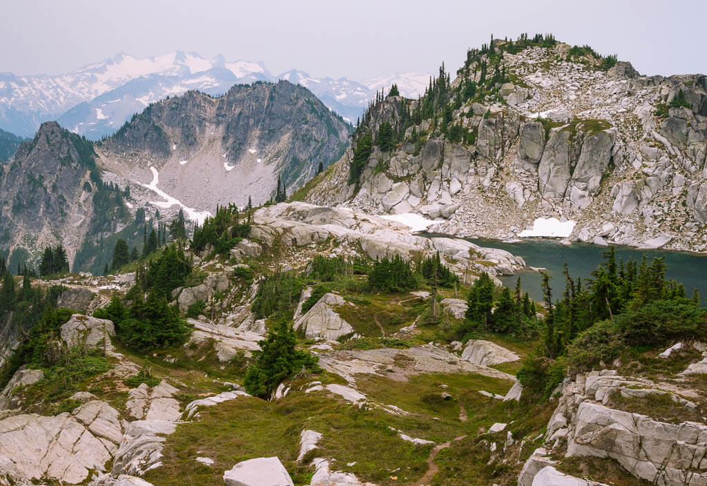
North Cascades National Park may be one of the least visited National Parks in the western United States but it is definitely one not to be overlooked with its desolate landscape and more than 300 glaciers.
Its alpine landscape of rugged mountain peaks, stunning glaciers, crystal clear lakes, cascading waterfalls, and lush forests is serene. Enjoy North Cascades’ vast wilderness along the scenic drive and more than 400 miles of hiking trails.
Best Things to Do
- Drive North Cascade Highway – This is arguably the most scenic highway in the state of Washington as it twists and turns through the mountains and lakes. Approximately 30 miles of this gorgeous road pass through the national park.
- Check out the Overlooks – There are dozens of dramatic overlooks but our favorites are the Gorge Lake Overlook to view the Skagit Gorge and the hydroelectric Gorge Dam, the Diablo lake overlooking the beautiful turquoise lake, and the Washington Pass Overlook for stunning vistas of Highway 20 and the Liberty Bell Mountain.
- Hike the Trails –
- Rainy Lake (0.2 miles, easy)
- Trail of the Cedars (0.3 miles, easy)
- Ladder Creek Falls (0.5 miles, easy)
- Thunder Knob (3.3 miles, moderate)
- Blue Lake (5 miles, easy to moderate)
- Maple Pass Loop (7.2 miles, moderate to difficult)
- Desolation Peak (7.9 miles, strenuous)
- Cascade Pass and Sahale Arm (12 miles, strenuous)
- Visit Stehekin – This is an extremely small community in the heart of North Cascades. With no roads leading to Stehekin, this is the perfect place to get away from the outside world and experience life a little slower.
What to Know Before Visiting North Cascade National Park
- You’re visiting the biggest glacial system in the USA other than Alaska.
- Book in Time. There is a high demand for accommodations in the summer months. Book 8-12 months in advance to make sure you get your desired overnight stay.
- Get a Northwest Forest Pass. To visit North Cascade National Park is generally for free but to park at the trailheads on adjacent national forests, you have to purchase a pass ($5 for a day, $30 for the year). You can get it directly at the trailhead or online.
North Cascade National Park Suggested Itinerary
DAY 1: Drive the North Cascade Highway, check out some viewpoints along the way, and hike Maple Pass Loop and some of the shorter, easy hikes.
DAY 2: Hike Cascade Pass and Sahale Arm Trail.
When to Visit
Being located in the upper part of the Pacific Northwest, North Cascade receives an extended winter season and some intense weather all year round. With the unpredictable weather, the best time to visit the park is from mid-June to September. During this time, you will have access to every section of the park and you can enjoy all of the various outdoor activities.
Where to Stay
Camping – Newhalem Creek Campground (NPS) → 5 other campgrounds are available within the park
Budget – Blue T Lodge
Midrange – North Cascades Inn
Olympic National Park
Location: Washington
Suggested Stay: 3 days
Entrance Fee: $30 per vehicle (valid for 7 days)
Highlights: Hurricane Ridge, Hoh Rainforest, beaches, waterfalls
Fun Fact: The Hoh Rain Forest in Olympic National Park receives over 12 feet of rain a year.
Closest Airport: Seattle-Tacoma International Airport (SEA)
Olympic National Park Official Website
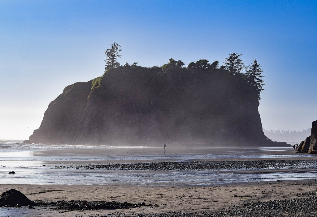
Olympic is one of the very unique and appealing west coast national parks. Its diverse landscape of dramatic mountain peaks, lush rainforests, and rocky coastlines with wide beaches quickly and easily captivates visitors.
The park’s diversity is truly a representation of the beauty of the Pacific Northwest.
Best Things to Do
- Visit Hoh Rain Forest – The Hoh is one of the finest examples of what is left of temperate rainforest in the United States. Hike the Spruce Nature Trail, a 1.2-mile loop, and the Hall of Moses, a 0.8-mile loop.
- Hike the Trails –
- Cape Flattery (1.5 miles, easy)
- Staircase Rapids Loop (2.1 miles, easy)
- High Ridge Trail / Mount Angeles via High Ridge Trail (5.5 miles, strenuous)
- Hurricane Hill via Hurricane Ridge (3.4 miles, moderate)
- Hike Enchanted Valley on the East Fork Quinault River Trail (13 miles, strenuous)
- Enjoy the Beaches of Olympic – Ruby Beach, Rialto Beach, Shi Shi Beach, and La Push Beaches.
- Chase Waterfalls of Olympic – Marymere Falls, Sol Duc Falls, Murhut Falls, Madison Falls.
- Drive Obstruction Point Road – Known as Washington’s scariest road, Obstruction Point Road has some pretty steep drop-offs and windy turns as it travels through the mountains. You can enjoy breathtaking vistas every second of your ride.
- See Lake Crescent – Go kayaking or canoeing on this gorgeous lake. If you are up for a hike, climb up the 5.3 miles strenuous Mount Storm King for unforgettable views of Lake Crescents from above.
What to Know Before Visiting Olympic National Park
- The park has four main areas. Map out the adventures you want to experience in Olympic and make a plan which area to visit and when.
- Spot some wildlife. Keep your eyes open for bears, bighorn sheep, foxes, elks, and coyotes.
- Visit the Twilight landmarks. Twilight was mainly filmed in Forks and the surrounding area of Washington.
Olympic National Park Suggested Itinerary
DAY 1: Northern Olympic Park – Hike parts of the High Ridge Trail, drive Obstruction Point Road, paddle Lake Crescent, and chase Marymere Falls, and Sol Duc Falls.
DAY 2: Pacific Coastline – Hike Cape Flattery, and explore the beaches (Shi Shi Beach, La Push Beaches, Rialto Beach, and Ruby Beach).
DAY 3: The Temperate Rainforest and Western Olympic National Park & Staircase and Eastern Olympic National Park – Explore the Hoh Rainforest, and hike the Staircase Rapids Loop.
When to Visit
The optimal and most popular time to visit Olympic National Park is during the warmer portion of the year, usually from June to August. Then, all roads are open, and temperatures are comfortable (60-80 degrees F) and stable to enjoy the outdoors.
If you want to avoid the crowds, plan a trip for May or September. During these months, weather conditions are still good and wildlife viewing is at its best.
Where to Stay
Camping – Sol Duc Hot Springs Resort Campground (NPS) →There are four other campgrounds in the national park
Budget – Olympic View Inn
Midrange – The Dew Drop Inn Motel
Mount Rainier National Park
Location: Washington
Suggested Stay: 3 days
Entrance Fee: $30 per vehicle (valid for 7 days)
Highlights: Mount Rainier, wildflowers, waterfalls
Fun Fact: Mount Rainier is a stratovolcano with the potential to erupt again
Closest Airport: Seattle-Tacoma International Airport (SEA)
Mount Rainier National Park Official Website
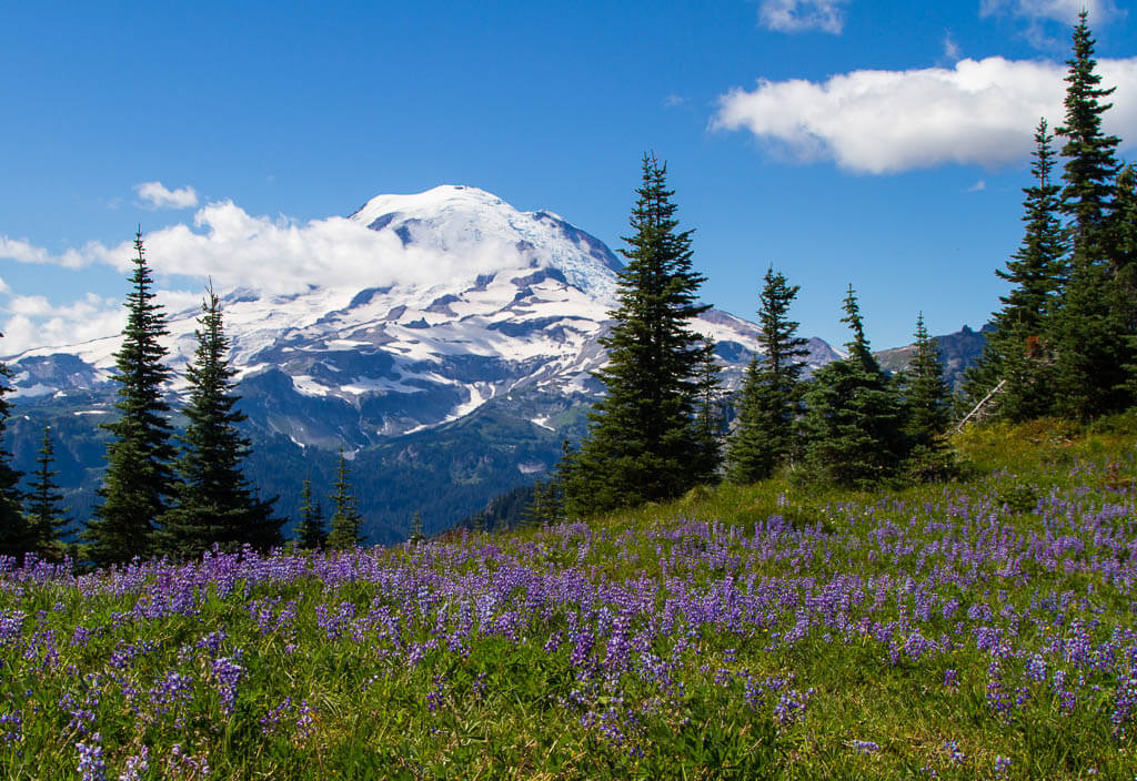
Mount Rainier is the most eye-catching and prominent peak within the entire Cascade Range. When you get lucky, you are even able to see the beautiful mountain from Seattle. Being one of the oldest U.S. National Parks it is no question that the park sees tons of visitors a year, which makes it one of the must-see west coast national parks.
This national park is a great playground for outdoor lovers who are seeking dramatic vistas of rugged mountains, spectacular alpine hikes, majestic old-growth forests, and powerful waterfalls.
Best Things to Do
- Explore all the areas of the park – Paradise, Sunrise, Longmire, Ohanapecosh, and Carbon River & Mowich
- Hike the Trails –
- Grove of the Patriarchs Trail (1.1 miles, easy)
- Pinnacle Peak Trail (2.8 miles, moderate)
- Sourdough Ridge Trail to Frozen Lake (3 miles, moderate)
- Tolmie Peak Lookout (5.6 miles, strenuous)
- Mt. Fremont Lookout Trail (5.7 miles, moderate)
- Skyline Trail Loop (6.2 miles, strenuous)
- Check out waterfalls – Myrtle Falls, Christine Falls, Comet Falls, Narada Falls, Silver Falls
- See the wildflowers – Catch this west coast park in full bloom when wildflowers take over the meadows usually around mid-July to early August.
- Travel the Scenic Drives – White Pass Scenic Byway and Chinook Byway
What to Know Before Visiting Mount Rainier National Park
- Large areas of the park are closed down during winter weather. If you plan on visiting outside the summer months, check closures ahead of time.
- Know where you want to go. There are 5 entrances to the park and not every area can be reached through all entrances.
- Check the temperature at Mount Rainier National Park. Temperatures can vary at different elevations in the park.
Mount Rainier National Park Suggested Itinerary
DAY 1: Drive up to Sunrise Point, hike the Sourdough Ridge Trail or the Mount Fremont Lookout trail, catch Myrtle Falls, and stroll along the Grove of the Patriarchs trail.
DAY 2: Hike the Skyline Trail to Panorama Point.
DAY 3: Hike to the Tolmie Peak Lookout.
When to Visit
Exploring Mount Rainier National Park is best during summer and early fall when the roads are open and the hiking trails are free of snow. A lot of areas of the park are closed in the wintertime.
Where to Stay
Camping – White River Campground (NPS) → There are three other campgrounds in Mt. Rainier National Park
Budget – National Park Inn
Midrange – Paradise Village Hotel
Crater Lake National Park
Location: Oregon
Suggested Stay: 1-3 days
Entrance Fee: $30 per vehicle (valid for 7 days) in the summer (May 22-October 31), $20 in the winter (November 1-May 21)
Highlights: Crater Lake, Rim Drive, Wizard Island
Fun Fact: Crater Lake is the deepest lake in America
Closest Airport: Eugene Airport (EUG), Rogue Valley International-Medford Airport (MFR), Portland International Airport (PDX)
Crater Lake National Park Official Website
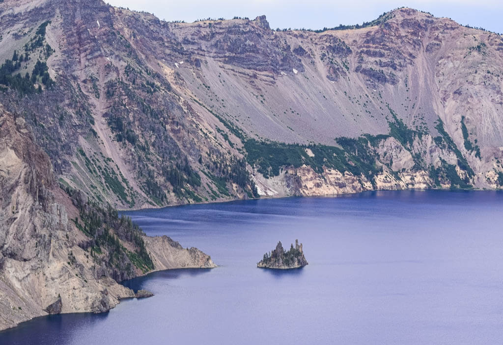
Crater Lake National Park is a rare park. It was created by a massive volcanic eruption which caused the mountain to collapse on itself. The lake is the hallmark feature in the park and the deepest lake in the country. It is also the 7th deepest lake in the world with its 1,943 feet depths.
Since the lake is filled almost entirely by snowfall, it is one of the clearest lakes in the world. To admire Crater Lake from above, take a scenic drive along the rim.
Best Things to Do
- Take the Scenic Rim Drive – Tour 33 miles around Crater Lake. The several viewpoints provide scenic vistas of the lake at every angle.
- Book a boat tour to Wizard Island – Book a tour to visit Wizard Island in Crater Lake, a 763-foot cinder cone that was created when the lake first filled with water after the volcano collapsed.
- Explore Cleetwood Cove Trail – This is a steep 1.1-mile trail down switchbacks providing the only access to Crater Lake. Once at the bottom, join others by jumping off a cliff into the lake.
- Admire Plaikni Falls – It is a 2.0-mile round trip hike through a lush forest to the base of a roaring waterfall surrounded by wildflowers.
What to Know Before Visiting Crater Lake National Park
- Fill up your gas tank. Don’t underestimate the size of this west coast park. You can drive 100 miles within the park, so make sure you have enough gas before entering Crater Lake National Park. During the summer, gas is also available in the Mazama Village Store in the park.
- Explore more than just the lake. Check out other park features, like the Plaikni Falls.
- Make reservations. Boat tours and accommodations are in high demand, so book ahead of time.
Crater Lake National Park Suggested Itinerary
DAY 1: Explore the Scenic Rim drive, hike down to the lake on the Cleetwood Cove trail, take the Plaikni Falls trail, and watch the sunset at Cloudcap Overlook.
DAY 2: Hike Mount Scott and/or Garfield Peak, enjoy Pinnacle Overlook
When to Visit
The best time to visit the park is during the months of July to September when all the roads, trails, and services are accessible.
Where to Stay
Camping – Mazama Campground (NPS) and Lost Creek Campground (NPS)
Budget – Crater Lake Lodge
Midrange – Union Creek Resort
Redwood National Park
Location: California
Suggested Stay: 2-3 days
Entrance Fee: Free
Highlights: Redwood trees, forest, Roosevelt Elk
Fun Fact: Coast Redwood trees are the tallest trees in the world, reaching up to 380 feet
Closest Airport: Rogue Valley International-Medford Airport (MFR), Sacramento International Airport (SMF), San Francisco International Airport (SFO)
Redwood National Park Official Website
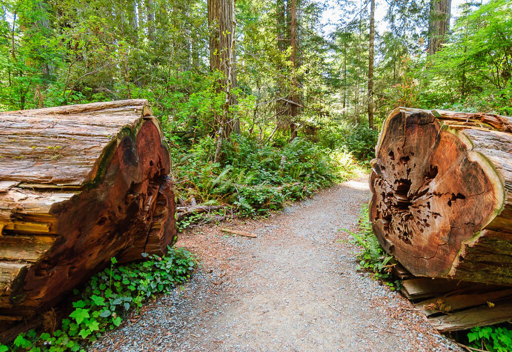
Redwood National Park has been taking root for thousands of years. These massive towering trees are one of the most surviving creatures on Earth. Here, you will find the world’s tallest and oldest trees in the National Parks of the west.
Besides the captivating Redwood forests, you can also explore 37 miles of untouched Pacific coastline.
Best Things to Do
- Walk Stout Grove Trail – Walk the short 0.5-mile trail. It is one of the most scenic Redwood groves in Jedediah Smith Redwoods State Park.
- Enjoy Lady Bird Johnson Grove – After a bumpy, narrow 2.5-mile ride up the Bald Hills Road, take the easy 1.5-mile walk through a grove.
- Visit Fern Canyon – This canyon is a very popular destination. The 1-mile trail passes through the forest and streams in a narrow canyon.
- Hike Boy Scout Tree Trail – Take the 5.5-mile round trip hike through an old-growth Redwood forest located in Jedediah Smith Redwoods State Park. To get to the trailhead you will have to bump and wind along the scenic Howland Hill Road.
- Explore Tall Tree Grove Trail – The Tall Tree Trail is a moderate to strenuous 4.5-mile round-trip hike to a stunning grove. There will be a steep drop of 800 feet in the first 1.5 miles. Before you start this trail, make sure it meets your needs and your physical ability.
- Take the Scenic Drives – Bald Hills Road, Newton B. Drury Drive, Howland Hill Road, Klamath Beach Road
- Tour the Avenue of the Giants – Take this mainly flat, incredible 31 miles scenic drive through the redwoods. It is actually known as one of the best forest drives in the world. The route is located in Humboldt Redwoods State Park, just a few hours south of Redwoods National Park.
What to Know Before Visiting Redwood National Park
- Redwood National Park and State Park are connected.
- Use the NPS app or Redwoods website for directions. Other GPS systems may not provide accurate directions.
- Get a permit if you want to hike to Tall Tree Grove. This hike gets a lot of attention, especially from travel bloggers. To protect the natural resources and give you a better hiking experience only 50 parties can obtain a permit each day. Apply for the permit up to 180 days in advance.
- Know the park’s road condition. Since road conditions can change rapidly, check their condition before starting your trip.
Redwood National Park Suggested Itinerary
DAY 1: Tour the Avenue of the Giants and hike the Tall Tree Grove Trail.
DAY 2: Drive the Newton B. Drury Drive, explore Fern Canyon, relax at Gold Bluffs Beach, and tour the Bald Hills Road to hike the Lady Bird Johnson Grove Trail.
DAY 3: Hike the Boy Scout Tree and the Walk Stout Grove Trail.
When to Visit
You can plan a visit to Redwood National Park anytime during the year thanks to its modest year-round temperature. However, it does tend to see a lot more rain during the winter months. It is usually drier between May and September.
Where to Stay
Camping – Jedediah Smith (NPS) → Redwoods National Park has 3 more developed campgrounds
Budget – Best Western Arcata Inn
Midrange – Harbor Lite Lodge
Lassen Volcanic National Park
Location: California
Suggested Stay: 1-3 days
Entrance Fee: $30 per vehicle (valid for 7 days)
Highlights: Lassen Peak, hydrothermal features
Fun Fact: The National Park has four shield volcanoes including Raker Peak, Red Mountain, Mount Harkness, and Prospect Peak.
Closest Airport: Sacramento International Airport (SMF), Reno-Tahoe International Airport (RNO)
Lassen Volcanic National Park Official Website
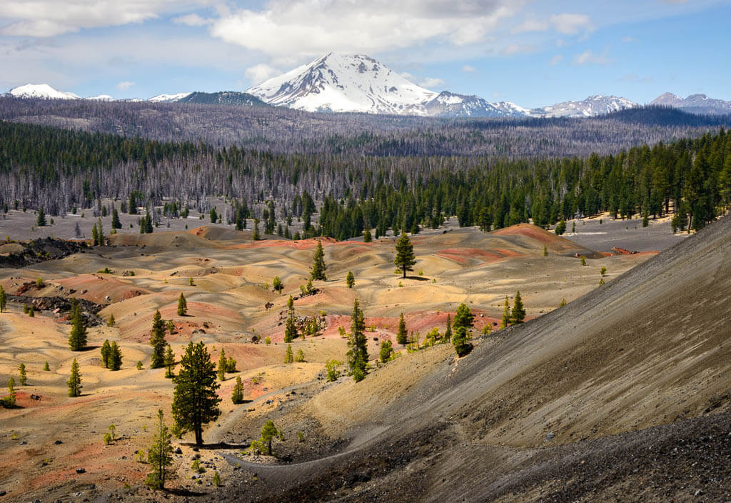
Lassen Volcanic National Park brings you back to the time when volcanoes controlled the land. The west coast park is even home to an active volcano. However, it has not erupted in over 100 years.
Here, you will find phenomenal hydrothermal features of flutter mud pots, sizzling pools, and roaring steam vents. The park’s main feature, Lassen Peak, is the largest plug dome volcano in the world.
Besides all this hydrothermal activity, the west coast park also features meadows of wildflowers and mountain lakes.
Best Things to Do
- Stroll around Manzanita Lake – Walk the 1.5-mile hiking trail around the lake or go kayaking.
- Admire Sulphur Works – Stop by the easily accessible Sulphur Works to admire the hydrothermal area of bubbling, rumbling, and stinging smell of sulfur.
- Relax at Lake Helen – Located at the base of Lassen Peak, Lake Helen is a deep blue lake that offers out of this world views. It is a great place to enjoy a picnic or take a dip in cold water.
- Hike Bumpass Hell – Hike the 3-mile trail through the largest hydrothermal area in the park. Make sure to stay on the designated trail as you are walking through a hydrothermal area that is full of acidic boiling water.
- Catch Kings Creek Falls – Hike the 2.3-mile loop passing Kings Creek Meadow to the 30-foot cascading waterfall.
- Learn about the park at Devastated Area – Stroll the quick Devastated Area Interpretive Trail which showcases the effects of the 1915 eruption of Lassen Peak.
- Climb Lassen Peak – Lassen Peak is the main feature of the National Park. Visitors can experience the summit of one of the largest plug dome volcanoes in the world after a 5-mile strenuous hike.
- Drive Lassen Volcanic National Park Highway – Drive the 30-mile road around the east side of Lassen Peak to connect the northwest and southwest entrances of the park.
What to Know Before Visiting Lassen Volcanic National Park
- Food is limited. There are not a lot of dining amenities and stores in Lassen Volcanic National Park. You can find the Camper Store, the Drakesbad Guest Ranch Restaurant, and the Lassen Cafe. It is a good idea to buy some supplies before you start your journey.
- The volcano is still active. Although the park is considered dormant, there is an extremely small chance the volcano could erupt.
Lassen Volcanic National Park Suggested Itinerary
DAY 1: Learn more in the Kohm Yah-mah-nee Visitor Center, go to Sulphur Works, hike the Bumpass Hell trail, relax at Lake Helen, and stroll along the Devastated Area trail and Manzanita Lake
DAY 2: Climb Lassen Peak, visit Kings Creek Falls
When to Visit
There is only a short window to visit Lassen Volcanic National Park from the time the snow melts and the snow arrives. The roads are usually open from July to October.
Where to Stay
Camping – Summit Lake North And South Campgrounds (NPS) → There are 6 more developed campgrounds in Lassen Volcanic National Park.
Budget – Manzanita Lake Camping Cabins (NPS)
Midrange – Americana Modern Hotel, Redding, Kalifornien, USA
Yosemite National Park
Location: California
Suggested Stay: 3-4 days
Entrance Fee: $35 per vehicle (valid for 7 days)
Highlights: Yosemite Falls, Half Dome, El Capitan, Bridal Veil Falls, Vernal Falls, Glacier Point
Fun Fact: Yosemite is home to one of the tallest waterfalls in the world – Yosemite Falls at 2,425 feet.
Closest Airport: Fresno Yosemite International Airport (FAT), San Francisco International Airport (SFO), Oakland International Airport (OAK), San Jose International Airport (SJC)
Yosemite National Park Official Website
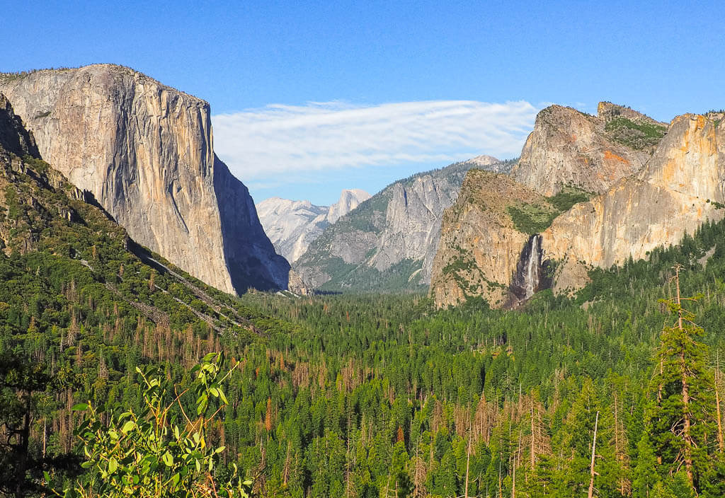
Yosemite is one of the most famous National Parks in the United States with its captivating waterfalls, massive granite rock formations, large valleys and meadows, and giant sequoia trees.
It is also one of the 3 California National Parks which are part of the Sierra Nevada mountain range.
Best Things to Do
- View Yosemite Falls – Check out one of the tallest waterfalls in the world Yosemite Falls which is made up of Upper Yosemite Falls (1,430 feet), the middle cascades (675 feet), and Lower Yosemite Falls (320 feet).
- Climb Half Dome – Half Dome is a large granite dome in Yosemite Valley. You can take the thrilling 14 to 16-mile round-trip hike up Half Dome (permit required) or admire it from a viewpoint like Glacier Point, Washburn Point, Tunnel View, or Cook’s Meadow.
- Relax at Tenaya Lake – Relax after your day of hiking at this beautiful alpine lake which sits between Yosemite Valley and Tuolumne Meadows.
- Enjoy Tunnel View – Don’t miss out on this most popular viewpoint in Yosemite. You can find it just outside the Wawona Tunnel on State Highway 41.
- Hike to waterfalls of Yosemite – Bridal Veil Falls, Vernal Falls, Nevada Falls.
- View a sunset at Glacier Point – Catch a beautiful sunset at Glacier Point when Half Dome gets illuminated in a pinkish color.
What to Know Before Visiting Yosemite National Park
- Start your day early to avoid some of the crowds.
- Parking is extremely hard to find in Yosemite Valley. You will most likely have to utilize the shuttle service for attractions in this area.
- Get a permit for Half Dome. You need a permit to ascend the sub dome steps or Half Dome cable.
Yosemite National Park Suggested Itinerary
DAY 1: Drive the Tioga Pass Road and stop at various viewpoints like Olmstead Point, have lunch at Tenaya Lake, visit Yosemite Valley, hike to Yosemite Falls and Bridal Veil Falls, check out Tunnel View, and enjoy a sunset at Glacier Point.
DAY 2: Hike to Vernal Falls and Nevada Falls.
DAY 3: Hike Half Dome.
When to Visit
The best time to visit Yosemite National Park is between the months of May and September. Unfortunately, many of the roads and trails within the west coast park are closed for a good portion of the year due to snow.
In the summer crowds are the heaviest, spring and fall offer a little more solitude. Spring is also best for wildflowers and waterfalls, and fall brings nice weather and vibrant colors.
Where to Stay
Camping – Wawona Campground (NPS) → Yosemite National Park has 12 more developed campgrounds.
Budget – Yosemite Bug Rustic Mountain Resort
Midrange – Yosemite View Lodge
Kings Canyon National Park
Location: California
Suggested Stay: 1-2 days
Entrance Fee: $35 per vehicle (valid for 7 days)
Highlights: General Grant Tree, Zumwalt Meadow
Fun Fact: The General Grant tree in Grant Grove is the world’s third-largest tree.
Closest Airport: Fresno Yosemite International Airport (FAT)
Kings Canyon National Park Official Website
Kings Canyon National Park sits below Yosemite National Park and is one of the National Parks in western United States that is part of the Sierra Nevada mountain range.
The park is most known for its large Sequoia trees, most notably the General Grant Tree. But it is also home to magnificent granite canyon walls in Cedar Grove and King’s River, and lush meadows.
Best Things to Do
- Walk to the General Grant Tree – Admire the second largest tree in the world at 268.1 feet tall. It is located in Grant Grove.
- Hike Zumwalt Meadow – This scenic meadow attracts a lot of wildlife. Explore the area on a 1.5-mile scenic trail showcasing high granite walls and the powerful King’s River.
- Catch the Roaring River Falls – Take the short and quick Roaring River Falls trail to a powerful cascading waterfall over granite monoliths.
- Tour the Kings Canyon Scenic Byway – Drive the 50 dramatic miles from the foothills outside of Fresno, California to the Cedar Grove area.
What to Know Before Visiting Kings Canyon National Park
- Kings Canyon National Park is divided into 2 sections: Grant Grove and Cedar Grove.
- Make it a 1-day trip. We visited Kings Canyon in 1 day during our USA cross-country road trip and had enough time to see all the highlights of the park.
- Keep an eye out for bears. Bears can be seen frequently in Kings Canyon National Park. Ask the park rangers for last sightings. When you encounter the furry animal, remember bear safety rules and watch them from a distance.
Kings Canyon National Park Suggested Itinerary
DAY 1: Explore Cedar Grove area: Drive Kings Canyon Scenic Byway, hike Zumwalt Meadow, and gaze at the stunning Roaring River Falls and Grizzly Falls
DAY 2: Explore Grant Grove area: Fish at Hume Lake, see General Grant Tree, and tour Generals Highway to Sequoia National Park.
When to Visit
For the best experience at Kings Canyon National Park try to visit between the months of June through August. During this time the weather is more reliable and the park is the most accessible.
Where to Stay
Camping – Lodgepole Campground (NPS) → Sequoia and Kings Canyon National Park have 13 more developed campgrounds
Budget – Lazy J Ranch Motel
Midrange – Comfort Inn & Suites Sequoia Kings Canyon
Sequoia National Park
Location: California
Suggested Stay: 1-2 days
Entrance Fee: $35 per vehicle (valid for 7 days)
Highlights: General Sherman Tree, Moro Rock, Crystal Cave, Tunnel Log
Fun Fact: The tallest mountain in the United States, Mt. Whitney is located in Sequoia National Park.
Closest Airport: Fresno Yosemite International Airport (FAT)
Sequoia National Park Official Website
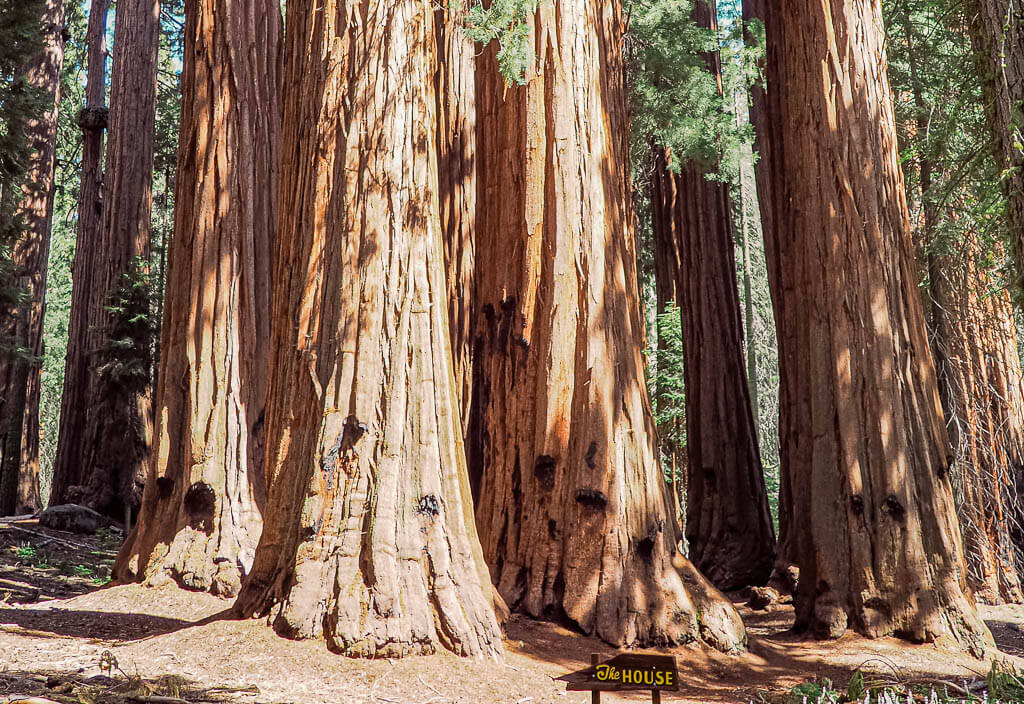
Sequoia National Park is contiguous to Kings Canyon National Park and the last of the 3 National Parks in the Sierra Nevada mountain range.
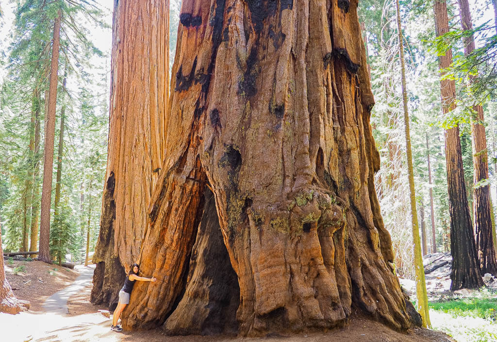
Just like its neighbor park, Sequoia National Park is best known for its extensive amounts of sequoia trees and being home to the largest tree in the world, General Sherman.
Best Things to Do
- Visit the Giant Forest Museum- To learn more about the Giant Forest with its trees and landmarks as well as human history in the park is a great introduction to your Sequoia National Park trip.
- General Sherman Tree – This is the largest tree in the world at 275 feet tall. If you plan on snapping a picture with the tree, expect some waiting time.
- Drive through a tunnel log – One popular tourist attraction in Sequoia National Park is the tunnel log. Ride your car through a carved opening of a fallen tree which is estimated 2,000 years old.
- Crescent Meadow – Walk around Crescent Meadow for a picturesque view.
- Moro Rock – Take the climb up Moro Rock. This massive granite dome towers over the edge of the Giant Forest providing great views. From the top, you can admire the Sierra Nevada mountains.
- Crystal Cave – Visit this extraordinary marble cave on a guided tour.
- Congress Trail – Stroll along the 2.7-mile round trip to feel like an ant as you walk through a forest of giant sequoia trees.
What to Know Before Visiting Sequoia National Park
- Kings Canyon and Sequoia National Park are two separate parks. Nevertheless, they are administered together by the National Park Service. That means you only have to pay the entrance fee for one park.
- Take a shuttle within the park. During the summer, free shuttle buses run in Kings Canyon National Park and Sequoia National Park. In the winter, only shuttles in Sequoia are scheduled.
- Explore underground. Most of the visitors come to enjoy the ancient Sequoia trees and don’t even realize that more than 200 caves were found underground. Book tickets to tour Crystal Cave, the second largest cave in the park, in advance.
Sequoia National Park Suggested Itinerary
DAY 1: Visit the Giant Forest Museum, see the General Sherman Tree, hike Congress Trail( and other hiking trails of choice), and catch Tokopah Falls.
DAY 2: Explore Crescent Meadow, drive through Tunnel Log, climb Moro Rock, and tour Crystal Cave.
When to Visit
The best time to visit Sequoia is in the summer from June through September. To avoid the crowds, plan your trip for May or October.
For a unique experience, come in the winter to get magical views of the snow-capped landscapes and experience exciting outdoor sports like snow-shoeing and cross-country skiing.
Where to Stay
Camping – Lodgepole Campground (NPS) → Sequoia and Kings Canyon National Park have 13 more developed campgrounds
Budget – Lazy J Ranch Motel
Midrange – Comfort Inn & Suites Sequoia Kings Canyon
Death Valley National Park
Location: California
Suggested Stay: 1-2 days
Entrance Fee: $30 per vehicle (valid for 7 days)
Highlights: Badwater Basin, Artist Palette, Devil’s Golf Course, Zabriskie Point, Dante’s View
Fun Fact: Death Valley is considered to be the driest region in the United States.
Closest Airport: Las Vegas McCarran International Airport (LAS)
Death Valley National Park Official Website
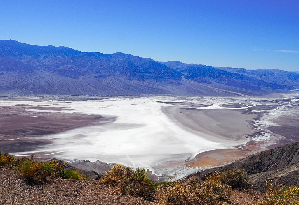
Death Valley National Park holds claim to being the hottest, driest, and the lowest out of all the United States National Parks. The west coast park is well known for unbearably hot record-setting temperatures and droughts. Out of all the west coast national parks on the list, this is definitely the hottest.
Just because the national park is located in the desert doesn’t mean you can only experience miles of sand. Most people don’t know that you will actually find a one-of-a-kind landscape in Death Valley with snow-capped mountains in the winter, an abundance of vibrant wildflowers in the spring, and colorful hills all year-round.
Best Things to Do
- Stroll around Mesquite Flat Sand Dunes – Walk along the sand dunes or admire the photogenic waves of the sand during sunrise or sunset.
- Admire Devil’s Golf Course – Check out the vast area of rock salt eroded by the wind and rain creating rugged spires.
- Step foot on Badwater Basin – Stop by the lowest spot in the United States.
- Tour Artist Drive & Artist Palette – Take the 9-mile one-way Artist Drive to see the miraculous array of colors of the Artist Palette hills.
- Enjoy the view from Zabriskie Point – Snap a photo of an iconic Death Valley vista or visit for a stunning sunset or sunrise.
- Visit Dante’s View – View Badwater Basin from above from 5,575 feet at Dante’s View.
What to Know Before Visiting Death Valley National Park
- Be prepared for the extremely hot weather. In the summer temperatures can rise up to 116 degrees F and you will barely find any shade in the west coast park. Limit your physical activities for your own safety.
- Pack lots of cold drinks. The higher the temperatures, the more you should drink to stay hydrated. You can fill up your water resources at the Visitor Center.
- Turn off your AC in the summer. To avoid overheating in Death Valley National Park, better open the car windows to get some airstream and give your AC a break.
- Your vehicle should be in good working condition. Due to the excessive heat, vehicles break down regularly from overheated engines.
Death Valley National Park Suggested Itinerary
DAY 1: Walk along the Mesquite Flat Sand Dunes, check out the Devil’s Golf Course, experience the lowest point at Badwater Basin, see the colors of the Artist Palette and stop at Zabriskie Point and Dante’s View to enjoy more iconic vistas.
When to Visit
Known as being the hottest place on earth, the best time to visit Death Valley National Park is during the offseason from October to May.
Where to Stay
Camping – Furnace Creek (NPS) → There are 8 more developed campgrounds in Death Valley National Park. Not all of them are open all year.
Budget – Stovepipe Wells Village
Midrange – The Ranch at Death Valley
Pinnacles National Park
Location: California
Suggested Stay: 1-2 days
Entrance Fee: $30 per vehicle (valid for 7 days)
Highlights: Pinnacle formations, Talus caves, California condor
Fun Fact: Pinnacles National Park is located near the San Andreas Fault line.
Closest Airport: San Jose International Airport (SJC), San Francisco International Airport (SFO)
Pinnacles National Park Official Website
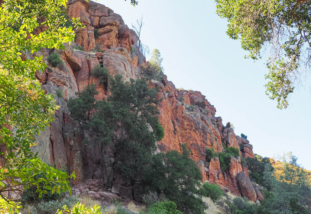
See fascinating rock formations made from erupting volcanoes millions of years ago in the smallest national park in California, Pinnacles. The park is split into two sections: the east and the west which are only connected by hiking trails. There are no roads between the two different areas.
Outdoor enthusiasts will find a lot of joy on the more than 30 miles of trails, including the stunning talus caves.
Best Things to Do
- Walk Bear Gulch Cave – Hike the 1.5-mile Bear Gulch Cave Trail which traverses the forest, cliffs, interesting pinnacle formations, and the iconic cave itself.
- Enjoy Condor Gulch Overlook – Take the moderate 1.9 miles hike to Condor Gulch Overlook via the Condor Gulch Trail to have a grand view of Condors that circle above the pinnacles.
- Hike High Peaks – Travel Pinnacles High Peaks to experience the best of the park.
- Explore Balconies Cave – Explore the 2.4-mile trail through the talus Balconies Cave.
What to Know Before Visiting Pinnacles National Park
- The park has 2 entrances. The east and the west entrances are NOT connected by a road. It takes an hour to get from one entrance to the other.
- Hike popular trails from both sections of the park. The Balconies Cave Trail and High Peak can be hiked starting at either entrance of Pinnacles National Park.
- Bring a light source. The flashlight and headlamp we brought came in very handy in the dark caves.
- Cooldown at the pool. If you are camping at Pinnacles make sure to take a refreshing dip in the public swimming pool.
- Take the shuttle. At the weekend and on holidays you can utilize the free shuttle between the East Pinnacles Visitor Center and Bear Gulch. It operates between 8:00 AM to 6:30 PM.
Pinnacles National Park Suggested Itinerary
DAY 1: Explore the Eastern Section – Hike Bear Gulch Cave and Condor Gulch Trail.
DAY 2: Explore the Western Section -Explore the High Peaks and Balconies Cave.
When to Visit
Contrastly to many other National Parks, a visit to Pinnacles is better during the cooler months of the year from October to May. When we hiked this park in August, we were extremely exhausted from the heat.
One of the best times to plan a trip is during the cooler spring when you can also see colorful wildflowers. Expect large crowds during that time of the year.
Where to Stay
Camping – Pinnacles Campground (NPS)
Budget – Days Inn by Wyndham King City
Midrange – Best Western Salinas Monterey Hotel
Channel Island National Park
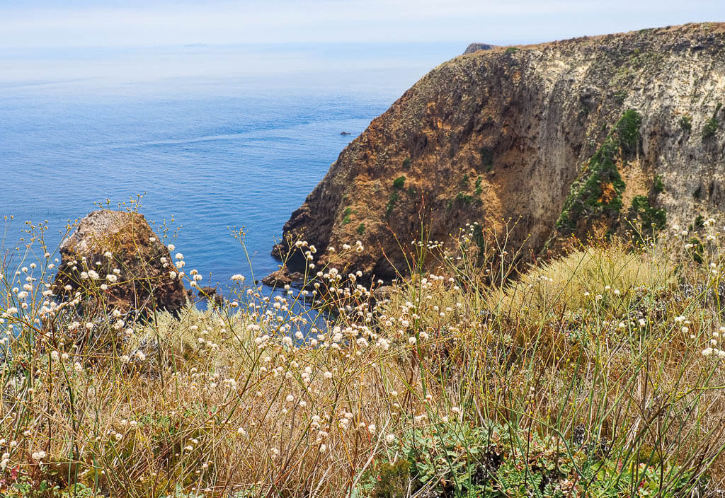
Location: California
Suggested Stay: 1-3 days
Entrance Fee: Free
Highlights: Sea caves, coastal views, sea life
Fun Fact: Santa Cruz on Channel Island National Park is home to one of the world’s largest sea caves
Closest Airport: Los Angeles International Airport (LAX)
Channel Island National Park Official Website
Channel Islands is one of the National Parks in western US which is located on an island. The west coast park is made up of 5 different islands: Santa Rosa, San Miguel, Santa Cruz, Anacapa, and Santa Barbara. Santa Cruz is the most easily accessible of these islands. It is one of the closest islands to the mainland and the frequency of boat trips to and from the island is quite high.
The park allows for a lot of classic land activities, such as hiking and camping, and stunning sea experiences like swimming, snorkeling, and kayaking. Especially the guided kayaking tour through the sea caves will leave you speechless.
This is one of the more unique west coast national parks.
Best Things to Do on Santa Cruz Island
- Take a sea kayaking tour – Book a sea kayaking tour around Santa Cruz Island to visit fascinating sea caves.
- Go snorkeling – Snorkel off the shores of Santa Cruz Island through the kelp forest and spot sea life.
- Hike the Island – Hike the easy 4.9 miles Potato Harbor Overlook Trail and the easy 1.7 miles Scorpion Bay to Cavern Point Loop for beautiful coastal views of the Pacific Ocean.
What to Know Before Visiting Channel Island National Park
- Camp at the island. We can’t recommend enough to stay overnight on Santa Cruz or one of the other islands. You almost have the island to yourself after the day tourists are gone.
- Plan in advance. Since you can NOT just drive to this national park, advance planning and booking of the ferry and campground are required.
- Pack everything you will need. There are no services available on the islands, so make sure you bring all your gear and food from the mainland.
- It can be very windy. The weather can be quite windy on Santa Cruz, so pack accordingly.
- Store your food properly. The island foxes on Santa Cruz are super adorable but also a little fresh. They like to get into your things to find food. Make sure to store all of your food and scented items in the animal-proof lockers at the campground.
- Visit the other islands. Even though Santa Cruz has the easiest access, it is absolutely worth it to visit the other Channel Islands. Boats to Anacapa Island and Santa Rosa Island operate a few times during the week, whereas boats only travel out and back from Ventura Harbor to San Miguel Islands and Santa Barbara Island a couple of times a month.
Channel Island National Park Suggested Itinerary
DAY 1: Take the ferry over to Santa Cruz, kayak the sea caves on a guided tour, snorkel the waters, and watch the sunset at Caverns Point.
DAY 2: Hike around the island before you take the ferry back.
When to Visit
The best time to visit Channel Island is also the busiest time to visit. The summer months from June through September provide perfect temperatures for hiking and wildlife viewing and warmer waters for sea activities.
Where to Stay
Camping – Scorpion Canyon (NPS) → There are 4 more campgrounds on the Channel Islands, one on each island.
Budget – Crystal Lodge Motel
Midrange – Blue Iguana Inn
Joshua Tree National Park
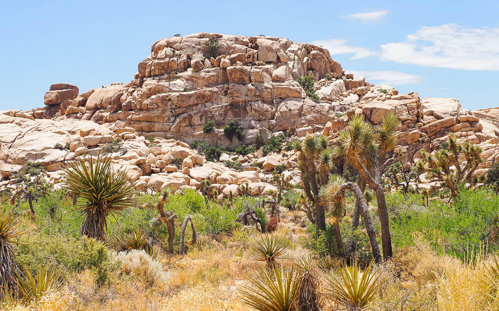
Location: California
Suggested Stay: 1-2 days
Entrance Fee: $30 per vehicle (valid for 7 days)
Highlights: Joshua Trees, cacti, desert landscape, Skull Rock
Fun Fact: Joshua Tree National Park is named after the Joshua Tree.
Closest Airport: Palm Springs International Airport (PSP), Los Angeles International Airport (LAX)
Joshua Tree National Park Official Website
Joshua Tree National Park is made up of 794,000 acres between the Mojave and Colorado deserts. It is home to the unique Joshua Tree, a spiny, twisted, palm tree-like plant that is actually a succulent.
Besides this famous ‘tree of the desert’, you can encounter complex landscapes in the different elevations of the park. Climb up massive granite boulders (Skull Rock), visit an old dam, and wander along cacti in the Cholla Cactus Garden.
Best Things to Do
- Explore Cholla Cactus Garden – Stroll through the unique cholla cactus garden on a 0.25 flat trail. It is a one-of-a-kind feature in Joshua Tree.
- Hike the Trails
- Hidden Valley ( 1mile, easy)
- Barker Dam Nature Trail (4.4 miles, easy)
- Ryan Mountain (2.9 miles, moderate)
- Admire Skull Rock – This is a park’s favorite. It is a large granite rock that has been eroded for years creating a skull-like image into the rock.
- Visit Cottonwood Spring Oasis – This section of Joshua Tree is one of the most overlooked places in the park featuring beautiful large fan palms.
- Trek Hall of Horrors – Hike the very unique Hall of Horrors trail which features dirt paths, rock scrambling, and a narrow, spectacular slot canyon.
- Rock climbing – Joshua Tree national park is a mecca for climbing fans with its more than 10,000 climbing routes in the granite.
What to Know Before Visiting Joshua Tree National Park
- Bring plenty of water, food, and supplies. You won’t find any water, and food services in the park. Keep in mind it gets extremely hot in the desert, so you need plenty of water to stay hydrated.
- Be flexible. Have a plan and a backup as the weather can sometimes put a damper on your plans.
- Watch out for coyotes, the park’s spirit animal. They can usually be seen after sunset or very early in the morning. Remember they are wild animals, so keep your distance.
- Drive slowly within the park. Desert Tortoises frequently cross the park, so watch out not to hit them. If you see one, it is best to let them pass on their own. To touch the tortoise could harm it.
Joshua Tree National Park Suggested Itinerary
DAY 1: Explore Cottonwood Spring Oasis, drive the Pinto Basin Road, stop at Cholla Cactus Garden, admire Skull Rock, and hike the Hidden Valley Trail
DAY 2: Hike the Barker Dam Nature Trail, explore the Hall of Horrors, trek up Ryan Mountain, and enjoy a sunset at Keys View.
When to Visit
Since Joshua Tree is located in the desert, it gets quite hot in the summertime (more than 100 degrees F during the day).
Spring (March to May) and fall (October to November) are optimal to visit this national park to do all the stunning outdoor activities this park has to offer.
Where to Stay
Camping – Ryan Campground (NPS) → Joshua Tree National Park has 7 more campgrounds
Budget – El Rancho Dolores Motel at Joshua Tree National Park
Midrange – Sunnyvale Garden Suites – Joshua Tree National Park
Haleakalā National Park
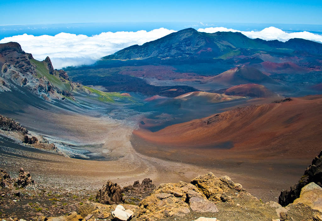
Location: Hawaii
Suggested Stay: 2 days
Entrance Fee: $30 per vehicle (valid for 7 days)
Highlights: See Haleakalā Summit at sunrise, hike Pīpīwai Trail, drive the Road to Hāna
Fun Fact: Haleakala National Park has more endangered species than any other United States National Park.
Closest Airport: Kahului Airport (OGG)
Haleakalā National Park Official Website
Haleakalā National Park is located on the island of Maui which showcases the native ecosystem of the Hawaiian Islands.
The park is named after Haleakalā, a huge shield volcano that makes up more than 75% of Maui. Besides the volcanic landscape, you can also see a totally different scenery in Haleakalā National Park. The Kīpahulu District features lush forests, powerful waterfalls, and breathtaking waterfalls.
Best Things to Do
- Watch a sunrise from the Haleakalā summit. On a clear day, you can expect unforgettable views of the sunrise or sunset from above the clouds since Haleakalā sits higher than the clouds. Another, easier accessible spot to see a sunrise is located 0.5 miles behind the Kapahulu Visitor Center.
- Drive the Scenic Highways. The Pinali Highway eventually turns into the Hana Highway. They both offer spectacular vistas of the landscape, but the Hana Highway is known for its thrilling driving experience through winding, narrow routes.
- Hike into the Haleakalā crater. Descend down 3.9 miles to the crater floor on the Keonehe’ehe’e Trail to explore the fascinating volcanic landscape up close.
- Visit the Bamboo Forest. Hike the Pipiwai Trail to find yourself in a gorgeous forest of extremely tall bamboo trees.
- Explore the Seven Sacred Pools of ‘Ohe’o. This series of pools are fed by a powerful cascading waterfall. Admire the beauty from afar and don’t try to access or even swim in them.
- Catch waterfalls. The 400 ft tall Waimoku Falls are by far the most popular waterfall in Haleakalā. To get a more secluded experience, visit Alele Falls. These falls are easily accessible due to their location next to the Hana Highway and are beautiful to look at.
What to Know Before Visiting Haleakalā National Park
- The park has two sections. The park is divided into the Summit District and the Kīpahulu District. The driving distance between those two parks is too big to explore them both in one day.
- Get permits. To watch the sunrise from the summit of Haleakalā you need to make a reservation two days in advance. You also need a reservation to visit the Black Sand Beach along the Road to Hana.
- Dress in layers. Temperatures can drop down to the 30s when the sun is not out. For the sunrise experience, it is best to wear long pants and multiple layers on top.
- Finding parking in Kīpahulu District is tough. Try to arrive early in the morning to snag a parking spot. Otherwise, you can expect to wait in line until a spot gets open.
Haleakalā National Park Suggested Itinerary
DAY 1: Explore the Summit District – View the sunrise from the summit of Haleakalā, take a break at the stunning overlooks, and hike into the crater.
DAY 2: Explore the Kīpahulu District – Drive the Hana Highway, visit the Kipahulu Visitor Center, hike the Pipiwai Trail to admire Waimoku Falls and the Bamboo Forest, and admire the Seven Sacred Pools in the ‘Ohe’o Gulch.
When to Visit
The dry season in Haleakalā National Park is from May through October. The summer is by far the busiest time. If you want to avoid the crowds but still visit in the dry season, plan a trip for May, September, or October.
Where to Stay
Camping – Kīpahulu Campground (NPS) or Hosmer Grove Campground (NPS)
Budget – Peace of Maui Bed and Breakfast
Midrange – Kohea Kai Maui, Ascend Hotel Collection
Hawaiʻi Volcanoes National Park
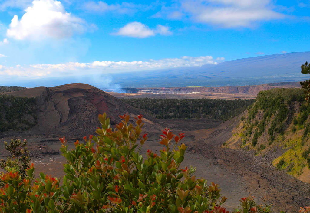
Location: Hawaii
Suggested Stay: 2 days
Entrance Fee: $30 per vehicle (valid for 7 days)
Highlights: See an (active) volcano flow, Thurston Lava Tube, Crater Rim Drive, petroglyphs
Fun Fact: Hawaiʻi Volcanoes is home to 2 active volcanoes.
Closest Airport: Hilo International Airport (ITO), Kona International Airport (KOA)
Hawai’i Volcanoes National Park Official Website
As the name suggests, you can guess Hawaiʻi Volcanoes National Park is home to volcanos. Actually two of the world’s most active volcanoes. The diverse landscapes in the west coast park range from sea level to the summit of the earth’s largest volcano at 19,999 cubic miles, Mauna Loa.
It is one of the National Parks in western US which really features how the powers of volcanoes and their ability to shape and reshape the land. It is located on the island of Hawai’i, also known as ‘The Big Island.’ Maybe you will have a chance of seeing lava flow if you time your visit just right.
Best Things to Do
- Drive Chain of Craters Road. See the trails of recent lava flows on this scenic 18.8 miles long route. Stop at the 90ft high Holei Sea Arch, a natural arch in the cliffs formed by lava. It is located on the coastline at the end of the Chain of Craters Road.
- See the lava flow. If you get the chance to visit Hawai’i Volcanoes National Park when Kīlauea is actively erupting, make sure to witness that natural spectacle. Depending on where the eruption takes place, there are different ways to see the lava flow. There are telescopes along Chain of Craters Road, you might be able to hike closer to the flow, or take a helicopter tour.
- Hike the Kīlauea Iki Trail. Trek the 3 miles roundtrip Kīlauea Iki Trail on a hardened lava lake to get a better understanding of the vast, volcanic landscape. You can also combine this trail with the Crater Rim Trail.
- Visit the Thurston Lava Tube. Carved out by a lava flow 500 years ago, you get the chance to walk through the impressive lava tube now.
- Tour the Crater Rim. It is understandable that the Crater Rim is the most popular drive in the park. On this 6 miles road, you can stop to see steam vents, sulfur banks, and get to dramatic overlooks. It also gives you access to some of the best things to do in Hawaiʻi Volcanoes National Park like the Thurston Lava Tube, the Kīlauea Iki Trail, and the Chain of Craters Road.
- See Petroglyphs. Did you know that you can find more than 23,000 petroglyphs in Hawaiʻi Volcanoes National Park? Take the 0.7-mile boardwalk to the Pu’u Loa Petroglyphs to admire some of them.
- Explore Mauna Loa. The easiest way to enjoy Mauna Loa is to drive the 11.2 miles of unpaved and very windy Mauna Loa Road to the overview. From there, you can adore vistas of the Kīlauea Caldera and the coast. To get to the summit, you have to hike a very strenuous 19-mile one-way hike.
What to Know Before Visiting Hawai’i Volcanoes National Park
- The park changed drastically in a short time. The conditions of this national park switch frequently. A recent example is the Kīlauea volcano. After some years of inactivity, it just erupted again in fall 2021. Visit the park’s website to see the latest eruptions.
- Parking is challenging. Parking is limited and especially the Thurston Lava Tube parking lot and the Kīlauea Iki trailhead fill up quickly. Arrive in the morning to secure your spot.
- Pack for a picnic. There are not a lot of facilities and dining options in the national park. The Volcano House and the Kilauea Military Camp are the only places where you can get some food, so bring your own lunch.
Hawai’i Volcanoes National Park Suggested Itinerary
DAY 1: Tour the Crater Rim and the Chain of Craters Road, hike the Kīlauea Iki Trail, visit the Thurston Lava Tube, and walk to the Pu’u Loa Petroglyphs.
DAY 2: Explore Mauna Loa.
When to Visit
Even though November through March is considered the rainy season, we would recommend visiting Hawai’i Volcanoes National Park during those months for fewer crowds. Rain showers usually last for only a few minutes and crowds are not as large as in the summertime.
The summertime gets the most visitors from the USA, so avoid planning your trip from June to the end of August.
Where to Stay
Camping – Nāmakanipaio (NPS) or Kulanaokuaiki (NPS)
Budget – Wild Ginger Hotel
Midrange – Castle Hilo Hawaiian Hotel
National Park of American Samoa
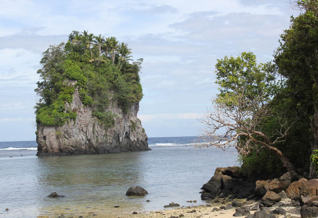
Location: American Samoa (U.S. Territory)
Suggested Stay: 4 Days, allow some additional time for transportation
Entrance Fee: Free
Highlights: Coral reefs, tropical rainforests, fruit bats
Fun Fact: The National Park of American Samoa is the only United States national park located on the south side of the equator.
Closest Airport: Pago Pago International Airport (PPG)
National Park of American Samoa Official Website
Journey outside of the United States to the 5 inhabited volcanic islands of American Samoa (10 islands in total) to visit the only U.S. National Park in the southern hemisphere.
Dive into the traditional Polynesian culture while exploring the rugged beaches and cliffs, waters filled with coral reefs, and tropical rainforest. The islands are inhabited by a variety of birds and the endangered flying fox, a huge fruit bat.
Best Things to Do
- Go Snorkeling or Diving in Ofu. Ofu has some of the best snorkeling spots in the national park to see more than 950 species of fish and over 250 species of corals. Plan on bringing your own snorkeling or diving gear since there are no rental options.
- Hit the Trails:
- Lower Sauma Ridge Trail (0.4 miles, easy)
- Oge Beach Trail (2.7 miles, moderate)
- Mount ‘Alava Trail (6.1 miles, moderate)
- Tuafanua Trail (2.2 miles, strenuous)
- Participate in the NPS Homestay Program. To get to know the Samoan people and their culture, you can stay in a traditional village and participate in their daily life routines. You can sign up for a homestay on Pago Pago, Ofu, and Ta’u. Contact the Visitor Center to get more information about prices etc.
- Go Fishing. Fishing is very popular in American Samoa. You can even get on a boat with a local fisherman to learn different traditional techniques on how to catch the fish.
- Visit Ofu Beach. Relax at the south beach for breathtaking beach scenery which is regularly featured in travel publications.
What to Know Before Visiting National Park of American Samoa
- American Samoa National Park is located on 3 different islands: Pago Pago (also called Tutuila), Ta’u, and Ofu. Fly to Pago Pago from California or Hawaii. From there, take a short plane ride to Ta’u. In Ta’u you can find local fishermen who can bring you to Ofu.
- Check out the Visitor Center. One of the first things to do is to go to the Visitor Center in Pago Pago to get more information about the national park and its trails and outdoor activities. It also offers great exhibits about the Samoan culture.
- Don’t underestimate solar radiation. The radiation is intense in American Samoa. Make sure to protect yourself by wearing sunscreen, sunglasses, a hat, and protective clothes.
- Ask for permission. When villagers are around, always ask for permission to take pictures, use the beach, or do something else on their land. Locals are extremely nice in American Samoa and your permission will most likely be granted.
National Park of American Samoa Suggested Itinerary
DAY 1-3: Participate in the Homestay Program, hit some trails, and go fishing.
DAY 4 Ofu: Relax at Ofu’s island south beach, go snorkeling or scuba diving, and hike the Oge Beach Trail.
When to Visit
American Samoa can be visited all year-round. Temperatures are always hot and it always tends to be rainy. From June to September it is slightly drier and temperatures decrease a little.
Where to Stay
Camping – There is no camping allowed in the American Samoa National Park but you can participate in a Homestay Program.
Budget – Sadie’s by the Sea
Midrange – Tradewinds
Bonus: West Coast National Parks in the Western United States
As we mentioned before, we simply had to include these stunning national parks on our west coast national parks list. Even though they are located more far away from the coast itself, they still belong to the western part of the U.S.
Let’s take a closer look at which national parks you can’t miss in the western states.
Yellowstone National Park
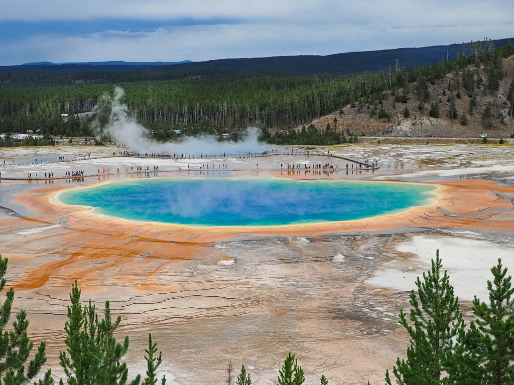
Location: Wyoming
Suggested Stay: 2-5 days
Entrance Fee: $35 per vehicle (valid for 7 days)
Highlights: Old Faithful, Grand Prismatic Spring, Geysers, Yellowstone Lake
Fun Fact: The park preserves more than 10,000 hydrothermal features. That means half of the world’s hydrothermal features are located within Yellowstone.
Closest Airport: Jackson Hole Airport (JAC)
Yellowstone National Park Official Website
Yellowstone National Park is probably the most famous National Park in the United States and the world. It is also the first-ever established National Park, which is why it is a must-visit on the west coast national parks list.
The park attracts extremely high numbers of visitors from all over with its rare geothermal features of geysers, hot springs, fumaroles, and mud pools.
Besides these spectacular features, Yellowstone is also home to diverse wildlife and the largest concentration of mammals in the lower 48 states which include bison, bighorn sheep, elk, moose, pronghorn, bears, wolves, and coyotes.
Best Things to Do
- Watch Old Faithful erupt – This geyser is probably Yellowstone’s main attraction. Watch Old Faithful erupt in intervals of roughly 90 minutes give or take. In the nearby Old Faithful Visitor Education Center, you can check the time of the last eruption. If you want to be in the front of the crowds to view Old Faithful, plan on arriving 30 minutes earlier.
- Admire the colors of Grand Prismatic Spring – This is the largest hot spring in the United States and the third in the world, as well as, one of the most unique natural wonders. You can walk next to the springs but also take the Grand Prismatic Overlook Trail to see the entire spring from a bird’s eye view.
- Spot wildlife in Lamar Valley – This is the place to be if you want to see Yellowstone’s wildlife in action. Here you will see an abundance of bison. It is a good chance you will even experience the infamous bison traffic jam. Hayden Valley also offers great chances of spotting wildlife.
- Visit Mammoth Hot Springs – These hot springs present a unique geothermal feature in Yellowstone. They have the largest number of hot terraces in the world. There are 3 terraces in total: the upper, lower, and main terraces.
- Stroll around West Thumb Geyser Basin – Take a stroll around the boardwalk in this smaller geothermal area of Yellowstone on the western side of Yellowstone Lake.
What to Know Before Visiting Yellowstone National Park
- Take your time! Have patience when exploring Yellowstone National Park and really appreciate the unique landscape and features in the park. With that in mind, also plan some extra time for your Yellowstone adventure.
- Book accommodation in advance. If you plan on staying in the park at a hotel, lodge, or campground, plan ahead. Some of the accommodations book out a year in advance.
- Know when and where to spot wildlife. Nature is unpredictable, so we can’t say for sure when you will see animals in Yellowstone. But most of the wildlife is more active and looking for food during dusk or dawn though.
- Hit the trails. Statistics say that 80% of the Yellowstone visitors don’t walk further than 10-15 minutes from their car. Hiking some trails is a great way to get away from the crowd and enjoy the beauty with more solitude.
- Don’t approach wildlife. Animals should always be watched from a safe distance. There are plenty of spots where you can stop and take some pictures from the safety of your car.
Yellowstone National Park Suggested Itinerary
DAY 1: Arrive through the south entrance, walk around West Thumb Geyser Basin, watch Old Faithful, check out the nearby Upper Geyser Basin, admire Grand Prismatic Spring and hike the Grand Prismatic Overlook trail, stop by at Gibbon Falls, Artists Paintpots, and the Norris Geyser Basin.
DAY 2: Visit Mammoth Hot Springs, spot animals in Lamar Valley, and check out Udine Falls, Boiling River, and Tower Fall.
DAY 3: Tour the North Rim Drive, and the Grand Canyon of Yellowstone South Rim Drive, hike Uncle Tom’s Trail, visit the Mud Volcano, and explore Hayden Valley.
When to Visit
Yellowstone can be visited and enjoyed anytime during the year, even though the park experiences heavy snowfall from November to March. Summer (June to August) is extremely crowded with more than 2 million visitors.
If you want to have a little more solitude, it is better to travel in the off-season. For this, you will want to come from late April to May and from September through October.
Where to Stay
Camping – Mammoth Campground (NPS) → There are 11 more developed campgrounds in Yellowstone National Park
Budget – Yellowstone Inn
Midrange – Lake Yellowstone Hotel
Grand Teton National Park
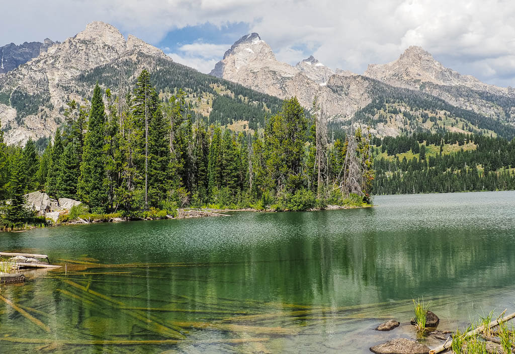
Location: Wyoming
Suggested Stay: 3 days
Entrance Fee: $35 per vehicle (valid for 7 days)
Highlights: Teton Range, lakes, wildlife, Jackson Hole
Fun Fact: Grand Teton National Park was established 2 times. First in 1929 to protect the mountain peaks and lakes around the base. Then second in 1950 to protect the nearby valley floor.
Closest Airport: Jackson Hole Airport (JAC)
Grand Teton National Park Official Website
Grand Teton National Park does not always get the credit it deserves. It gets overshadowed by the favorable neighboring National Park, Yellowstone.
Although you won’t find out of this world’s features like in Yellowstone, Grand Teton will captivate you with its dramatic mountain scenery and wildlife.
If you are making an effort to visit Yellowstone, you should definitely spend a few extra days and explore the Grand Tetons.
Best Things to Do
- Tour the Grand Teton Scenic Drive – This 42-mile loop through Grand Teton National Park is a park visitor’s favorite, offering jaw-dropping views of the iconic elevation profile of the mountains.
- Drive up Signal Mountain – Take the drive up to the summit for sweeping views of the park, the Teton Range, and Jackson Lake.
- Enjoy Jenny Lake – Take the Jenny Lake Scenic Drive, relax at the beach, or get out on the waters in a kayak.
- Visit Mormon Row Historic District – Learn more about the expansion of the Mormon settlers in the Tetons in the 19’s century in the Mormon Row Historic District. Two historic barns are still giving an example of life back in the day and are also one of the best photography spots in the park.
- Check out Schwabacher Landing – Catch a scenic view of the Teton Range and their fascinating reflection in the pond. This area is also great for watching beavers working to enlarge the dam.
- Hike Taggart Lake – Take the easy 3.8 miles hike around Taggart lake for outstanding views of the Tetons.
What to Know Before Visiting Grand Teton National Park
- Visit the cute town of Jackson Hole. Make time to explore the town of Jackson Hole, Wyoming, right outside the park. It is also a great place to book some adventurous tours like rafting, horseback riding, wildlife viewing tours, and more.
- The summers are very busy. Visiting during the summer is great temperature-wise but also comes with a prize. The park is very crowded and parking is hard to find at popular destinations. Start your day early to beat the crowds.
- Remember bear safety. A variety of animals, including Black and Grizzly bears, can be found in Grand Teton National Park. Always encounter animals from a safe distance. When camping, store your food and scented items in an animal-resist locker or leave them in your car.
Grand Teton National Park Suggested Itinerary
DAY 1: Drive Teton Park Road, relax at Jenny Lake, check out Inspiration Point, Hidden Falls, and Cascade Canyon.
DAY 2: Hike Taggart Lake, relax by String Lake, drive the scenic Gros Ventre Road and the Antelope Flats Road loop, visit Mormon Row, and spend the evening in Jackson Hole.
DAY 3: Snap a picture at Schwabacher Landing, take the drive up Signal Mountain, and visit Oxbow Bend.
When to Visit
The best time to visit Grand Teton National Park is between June to October when all the visitor centers and roads are open to travelers.
From November to mid-May, many of the scenic roads are closed due to the intense winter with heavy snowfall in that area.
Where to Stay
Camping – Jenny Lake Campground (NPS) → There are 7 more developed campgrounds in Grand Tetons National Park
Budget – Togwotee Mountain Lodge
Midrange – Teton Teepee Lodge
Zion National Park
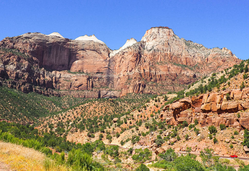
Location: Utah
Suggested Stay: 2-3 days
Entrance Fee: $35 per vehicle (valid for 7 days)
Highlights: The Narrows, Angels Landing, The Subway, Zion Canyon
Fun Fact: Before Zion was a National Park it was a National Monument, known as Mukuntuweap.
Closest Airport: Las Vegas McCarran International Airport (LAS), Salt Lake City International Airport (SLC)
Zion National Park Official Website
Zion National Park is Utah’s 1st National Park and one of the most visited parks in the United States. Although technically not one of the west coast national parks, it does lie within the western states of the U.S. and it is absolutely one not to miss.
Zion is full of outdoor adventures and home to some of the best hiking opportunities in the United States. Don’t miss out on the thrilling Angel’s Landing trail, and the impressive The Narrows slot canyon hike.
Best Things to Do
- Tour the Scenic Drives – The Zion-Mount Carmel Highway is an iconic drive through some natural sandstone tunnels you don’t want to miss.
- Hit the Trails
- Canyon Overlook Trail (1 mile, moderate)
- Emerald Pools Trail (3 miles, moderate)
- Hidden Canyon Trail (3.1 miles, moderate)
- Observation Point (7 miles, moderate)
- Angels Landing (4.4 miles, strenuous)
- The Subway (9.1 miles, strenuous)
- The Narrows (There are different routes to hike The Narrows)
- Get off the beaten path. Drive to the Kolob Canyon area, 40 miles north of Zion Canyon to find more solitude. This section offers a 5-mile scenic drive, and some stunning hiking trails, like the easy 1.1 miles Timber Creek Overlook Trail.
- Visit the Zion Human History Museum. Learn more about the American Indian culture, and early pioneers, as well as the huge effects water, has had on the park in the fascinating exhibits this museum provides.
- Go rock climbing. Zion National Park is a world-renowned location to go rock climbing. Most of the routes up the 2,000 ft sandstone cliffs are only recommended for experienced climbers though.
Read More: 13 Best Hikes in Zion National Park to Explore
What to Know Before Visiting Zion National Park
- Take the shuttle bus. During most parts of the year, a shuttle bus is operating in the park. When the Zion Shuttle is running, you can’t drive the main road, Zion Canyon Scenic Drive. Make sure to check the shuttle schedule before your trip.
- Get permits in advance. You need to get a permit for the following activities in Zion:
- Arrive early. Zion National Park is one of the most visited National Parks in the United States and is usually crowded year-round. We would highly suggest arriving at the park as early as you can to get a parking spot and avoid the crowds as much as possible.
- Know the weather. For some trails in Zion, it is crucial to know the weather and the trail conditions, especially those which involve water. Flash floods and strong currents can be dangerous, so check in the Visitor Center before you start your hike.
Zion National Park Suggested Itinerary
DAY 1: Hike Angels Landing, walk the Canyon Overlook trail, drive along Zion-Mount Carmel Highway, and explore Springdale.
DAY 2: Explore The Narrows, hike the Lower Emerald Pools Trail, and catch a sunset.
DAY 3: Hike the Subway OR Hidden Canyon Trail OR Observation Point.
When to Visit
It is best to visit Zion National Park in the spring and fall, which are the months of April – May, and September – October.
These times of the year are ideal because it’s mostly sunny with the temperature not being too high. However, you may experience some more rain during this time.
Where to Stay
Camping – South Campground (NPS) → There are 2 more developed campgrounds in Zion National Park
Budget – Zion Glamping Adventures
Midrange – Flanigan’s Inn
Bryce Canyon National Park
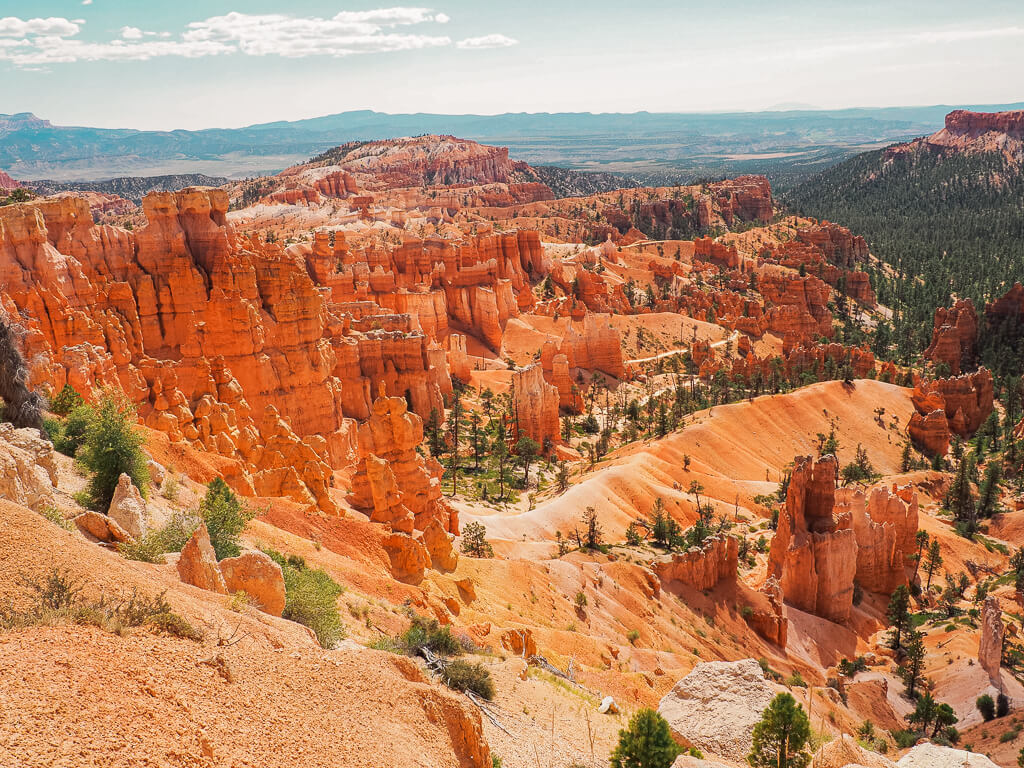
Location: Utah
Suggested Stay: 1-3 days
Entrance Fee: $35 per vehicle (valid for 7 days)
Highlights: Bryce Amphitheater, hoodoos, wildlife
Fun Fact: Bryce Canyon is home to some of the darkest skies in the United States, which is perfect for stargazing.
Closest Airport: Las Vegas McCarran International Airport (LAS), Salt Lake City International Airport (SLC)
Bryce Canyon National Park Official Website
Bryce Canyon is a small National Park in the American Southwest with an amazingly unique landscape.
It is home to the largest collection of hoodoos in the world. The highest concentration of hoodoos can be found at the Bryce Canyon Amphitheater.
No matter what type of adventurer you are, you can easily explore the hoodoos on various easy to strenuous hiking trails in the park.
Best Things to Do
- Tour the Bryce Canyon Scenic Drive. Experiencing the Bryce Canyon Scenic Drive is the easiest and quickest way to encounter the famous hoodoos. The drive runs the entire length of the park (38 miles) which allows visitors to see all angles of Bryce Canyon from the 13 viewpoints along the route.
- Hike the Trails
- Mossy Cave Trail (1 mile, easy)
- Rim Trail (3.9 miles, easy)
- Queens Garden & Navajo Loop Trail (2.9 miles, moderate)
- Peekaboo Loop Trail (5.2 miles, moderate)
- Fairyland Loop Trail (7.8 miles, moderate)
- Watch the Sunrise and/or sunset. Arrive in time to get a parking spot because watching the sunrise or setting down is a favorite activity in the park. These are some great spots to observe the spectacle:
- Sunrise Point
- Sunset Point
- Bryce Point
- Inspiration Point
Read More: Best Bryce Canyon Hikes
What to Know Before Visiting Bryce Canyon National Park
- Take the shuttle. Help the environment by using the free shuttle service in Bryce Canyon to get around. It is extremely easy to use and brings you to all the viewpoints and trailheads.
- Be aware of the altitude. Bryce Canyon National Park sits at a higher elevation, with more than 8,000 feet at its highest point. Especially when hiking up from the Amphitheater, you could experience shortness of breath.
- Start your day early. Getting up early is not our favorite thing to do but it helps to maximize your time and escape the crowds on the trails or the scenic drive.
- Keep an eye out for wildlife. As we were driving along the Bryce Canyon Scenic Drive we spotted Prairie Dogs popping in and out of their holes and deer relaxing in the pine forests along the road. If you are very lucky, you could also encounter mountain lions, pronghorn deer, and rattlesnakes.
Bryce Canyon National Park Suggested Itinerary
DAY 1: Watch the sunrise, hike the Queens and Navajo Loop, and drive the Bryce Canyon Scenic Drive.
DAY 2: Trek the Fairyland Loop Trail, and walk the Mossy Cave Trail.
When to Visit
Bryce Canyon National Park is a 4 season park. Every season brings different advantages. Just be aware that depending on the winter, some sections of the park could still be closed in early spring.
We would recommend visiting in the spring or fall when the temperatures are perfect to comfortably enjoy the outdoors. The months of April – May, and September – October bring ideal temperatures ranging from 60 degrees Fahrenheit to around 90 degrees Fahrenheit.
Where to Stay
Camping – North Campground (NPS) and Sunset Campground (NPS)
Budget – Bryce UpTop Lodge
Midrange – Best Western Plus Bryce Canyon Grand Hotel
Arches National Park
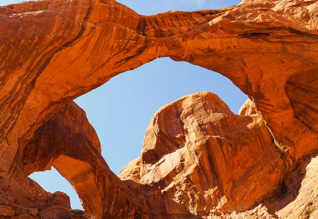
Location: Utah
Suggested Stay: 1-2 days
Entrance Fee: $30 per vehicle (valid for 7 days)
Highlights: Delicate Arch, Landscape Arch, Double Arch, Sand Dune Arch, Fiery Furnace
Fun Fact: Over 2,000 arches have been found and recorded in Arches National Park.
Closest Airport: Salt Lake City International Airport (SLC)
Arches National Park Official Website
Nestled in the beautiful state of Utah is Arches National Park. The park has more than 2,000 natural arches, and everyone is uniquely shaped. Arches actually have the highest number of natural arches in one fixed place than any place in the world.
This is one of the not so west coast national parks that is perfect for all types of travelers. You can easily explore the park’s incredible features from the road, on casual strolls, or on moderate to difficult hikes.
But one thing is for sure, no trip to Arches is complete without seeing Delicate Arch which is the iconic symbol for Utah.
Best Things to Do
- Check out Delicate Arch – Delicate Arch is not just the largest freestanding natural arch in the park, it is also one of the most famous Utah landmarks and can even be seen on the state’s license plates. You can admire Delicate Arch from the Lower and Upper Delicate Arch viewpoint from afar or hike the 3.2 miles moderate trail to get up close.
- Hike the Trails to Unique Arches
- Double Arch (0.5 miles, easy)
- The Windows (1 mile, easy)
- Landscape Arch (1.9 miles, easy)
- Double O Arch (4.1 miles, strenuous)
- Drive Arches Scenic Drive – This scenic route is a 36-mile long drive through the park. Plan 3 to 3.5 hours for the whole drive, including some quick stops to enjoy the breathtaking scenery.
- Get Lost in the Fiery Furnace. Hike Arches National Park’s most challenging section, the Fiery Furnace. This area will have you twisting and turning through a narrow network of sandstone canyons, and boulders. You can also book a ranger-led guided tour.
- Watch the Stars. Arches National Park is a certified Dark Sky Park and offers excellent opportunities to watch the night sky.
Read More: Best Trails to Hike in Arches National Park
What to Know Before Visiting Arches National Park
- Get a permit. To access the main scenic drive in Arches National Park with your own vehicle, you need to obtain a timed entry ticket. You also need a permit to explore the Fiery Furnace section of the park.
- Arches National Park has very little shade. Make sure you are equipped with sunscreen, a hat, sunglasses, sun protection clothing, and plenty of water to stay hydrated.
- Bring your own food and drinks. There is no food or drink sold within the park, so make sure you are prepared with all the snacks and drinks you will need for your visit. If you need to fill up your water in the park, you can use either the water filling station at the Visitor Center or at the Devils Garden Trailhead.
Arches National Park Suggested Itinerary
DAY 1: Tour the Arches Scenic Drive with its viewpoints, hike Double Arch, Delicate Arch, Landscape Arch, and Sand Dune Arch.
DAY 2: Explore Fiery Furnace, and go stargazing at night.
When to Visit
Similar to the other Mighty 5 national parks, Arches National Park can be visited in all seasons, but the most popular time of year is spring (April-May) and fall (September-October).
During these seasons daytime temperatures are the most enjoyable for outdoor activities, ranging from 60-80 degrees.
Where to Stay
Camping – Devils Garden Campground (NPS)
Budget – The Virginian Motel
Midrange – Under Canvas Moab
Canyonlands National Park
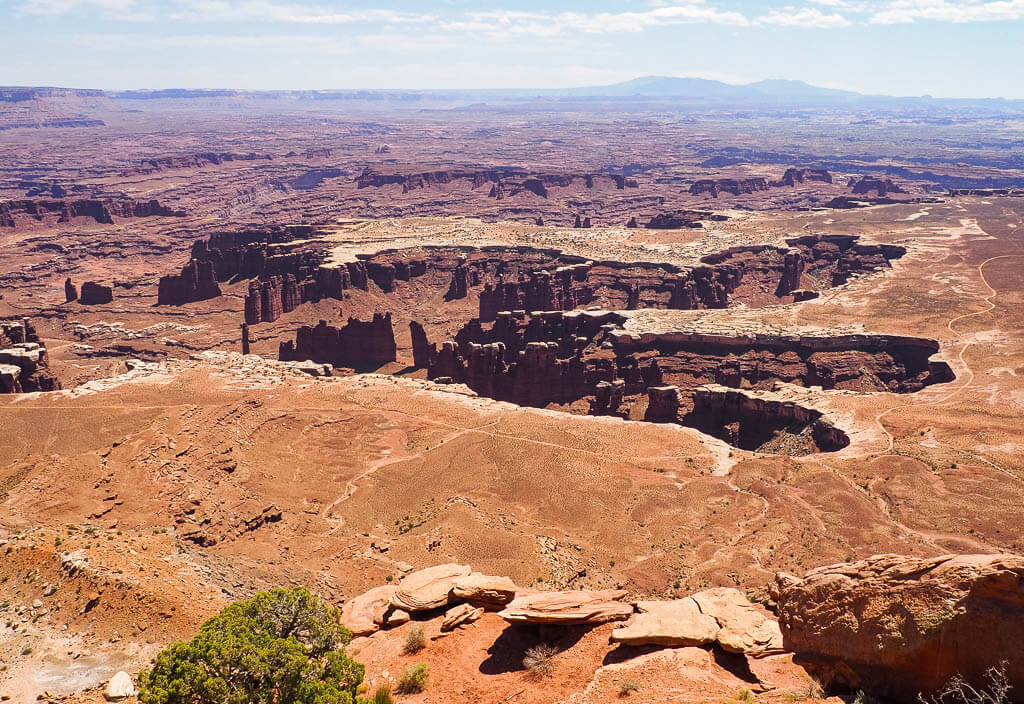
Location: Utah
Suggested Stay: 1-2 days
Entrance Fee: $30 per vehicle (valid for 7 days)
Highlights: Mesa Arch, scenic overlooks, Upheaval Dome, White Rim Road
Fun Fact: Canyonlands National Park is split up into 4 districts: Island in the Sky, Needles, the Maze, and the Rivers.
Closest Airport: Salt Lake City International Airport (SLC)
Canyonlands National Park Official Website
Canyonlands National Park is often overlooked by its more popular neighboring National Park, Arches. The park is made up of wide lands of rough canyon and desert landscape which has been sculpted and shaped by the Colorado and Green Rivers.
Here, you get more canyons and fewer arches than in Arches National Park, although Canyonlands does have 80 natural arches.
Best Things to Do
- Explore Island in the Sky. Check out the attractions in the most popular area of the park. Read more about the best of Island in the Sky Canyonlands.
- Tour the Island in the Sky District on the Scenic Drive. Make your way along the 34-mile drive and don’t forget to stop to check out the various viewpoints and go on some of the best hikes, like the Grand Viewpoint, Whale Rock, or Aztec Butte.
- Drive the White Rim Road. This route is 100-miles in length and goes around and below the Island in the Sky district. You will need a 4×4 vehicle with a high clearance to survive the rough road conditions. A Permit is required.
- Hike to Mesa Arch. This natural arch is one of the most popular features in the Island in the Sky Canyonlands. That makes it one of the most recognizable and photoed spots in the park.
- Visit Upheaval Dome. This crater is a unique geological feature in the park with its impressive size of approximately three miles across.
What to Know Before Visiting Canyonlands National Park
- The National Park is divided into different sections: Island in the Sky, the Needles, the Maze, and the Rivers. The most popular and most visited district is the Island in the Sky area since it is the easiest to reach. Taking a look at a map the districts do not seem to be too far from each other, but in reality, hour-long car rides separate them.
- Canyonlands National Park has very little shade. Especially when exploring this park in the summer, be precautious and use plenty of sunscreen, wear sunglasses and protective clothing and drink plenty of water.
- Get an early start. You won’t regret getting up early to catch a memorable sunrise at Mesa Arch.
- Stay up late. If you are not an early bird, watch the sunset at Dead Horse Point State Park instead.
Canyonlands National Park Suggested Itinerary
DAY 1: Watch the sunrise at Mesa Arch, tour the Island in the Sky Scenic Drive, stop at various viewpoints, visit Upheaval Dome, and add other short hikes.
+DAYS: Explore the harder-to-reach areas of Canyonlands in the Needles, Maze, and Rivers district or drive the White Rim Road.
When to Visit
Canyonlands can be visited year-round. The most popular times to see this west coast national parks are spring and fall when the summer sun is not beating on you and temperatures are more comfortable.
Where to Stay
Camping – Willow Flat Campground (NPS)
Budget – The Virginian Motel
Midrange – Under Canvas Moab
Capitol Reef National Park
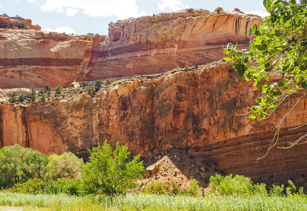
Location: Utah
Suggested Stay: 1-3 days
Entrance Fee: $20 per vehicle (valid for 7 days)
Highlights: Fruita District, Capitol Reef Scenic Drive, petroglyphs, Grand Wash, Hickman Bridge
Fun Fact: Capitol Reef National Park is home to the water pocket fold.
Closest Airport: Salt Lake City International Airport (SLC)
Capitol Reef National Park Official Website
Capitol Reef is one of Utah’s Mighty 5 National Parks. Although overseen by many, this National Park is a hidden gem in the heart of red rock country, located in south-central Utah.
Out of the 5 Utah National Parks, Capitol Reef is hands down probably the least visited and most underrated park. With this, you would be shocked because the park is no less than its neighbor parks in regards to its beauty, unique features, landscape, and hiking opportunities.
If you are looking for one of the west coast national parks with fewer crowds, this is the place for you.
Best Things to Do
- Hike the Trails
- Capitol Gorge (2 miles, easy)
- Grand Wash (6.9 miles or 4.4 miles, easy)
- Hickman Bridge (1.8 miles, moderate)
- Cassidy Arch (3.4 miles, strenuous)
- Sulphur Creek (5.8 miles, strenuous)
- Visit the Fruita Historic District. This area is considered the center of Capitol Reef National Park. Stop in at the Gifford House for some delicious treats or pick your own fruits in the Fruit Orchards.
- Look at the Petroglyph Panel. The colorful Petroglyph Panel is located on the rock panels of the cliffs that run parallel to Highway 24. It gives us an idea of how the Fremont and Ancestral Puebloan people lived and communicated from 600 to1300 AD.
- Tour the Capitol Reef Scenic Drive. This drive is 7.9 miles long and will take you around 1.5 hours to complete. It is a paved, easily traveled road with 2 spur dirt roads, Grand Walsh and Capitol Gorge. There are 11 viewpoints along the way.
Read More: Best Capitol Reef Hiking Trails
What to Know Before Visiting Capitol Reef National Park
- Check the road conditions. Before traveling to Capitol Reef National Park take a look at the road conditions. They can easily change, depending on the weather. For up-to-date information call the park’s automated phone system at (435) 425-3791.
- Know the weather before you visit Capitol Reef National Park. Flash floods are not uncommon, especially during the monsoon season from July to September. However, flash floods can happen at all times of the year. A flash flood can severely impact your trip as it can make traveling through the park very difficult and sometimes even impossible.
- Leave No Trace. Please recreate responsibly. Anytime you visit a United States National Park or you are just enjoying the outdoors, it is important to remember to follow the Leave No Trace principles. Respect and appreciate nature, so that future generations can enjoy the same beauty.
Capitol Reef National Park Suggested Itinerary
DAY 1: Drive Capitol Reef Scenic Drive, hike Capitol Gorge and Grand Wash.
DAY 2: Pick fruits at the Fruita Historic District, drive Highway 24 through the park, visit Petroglyph Panel, and hike to Hickman Bridge.
DAY 3: Add more hikes from your wishlist.
When to Visit
Capitol Reef National Park is open all year round, but certain services may not be available every month.
Just like its neighbor National Parks in Utah, the best time to visit Capitol Reef is in the spring (March to June) and fall (September to October). The weather is ideal for hiking, with minimal chance of bad winter weather or monsoon rains.
Where to Stay
Camping – Fruita Campground (NPS)
Budget – Broken Spur Inn & Steakhouse
Midrange – Capitol Reef Resort
Rocky Mountain National Park
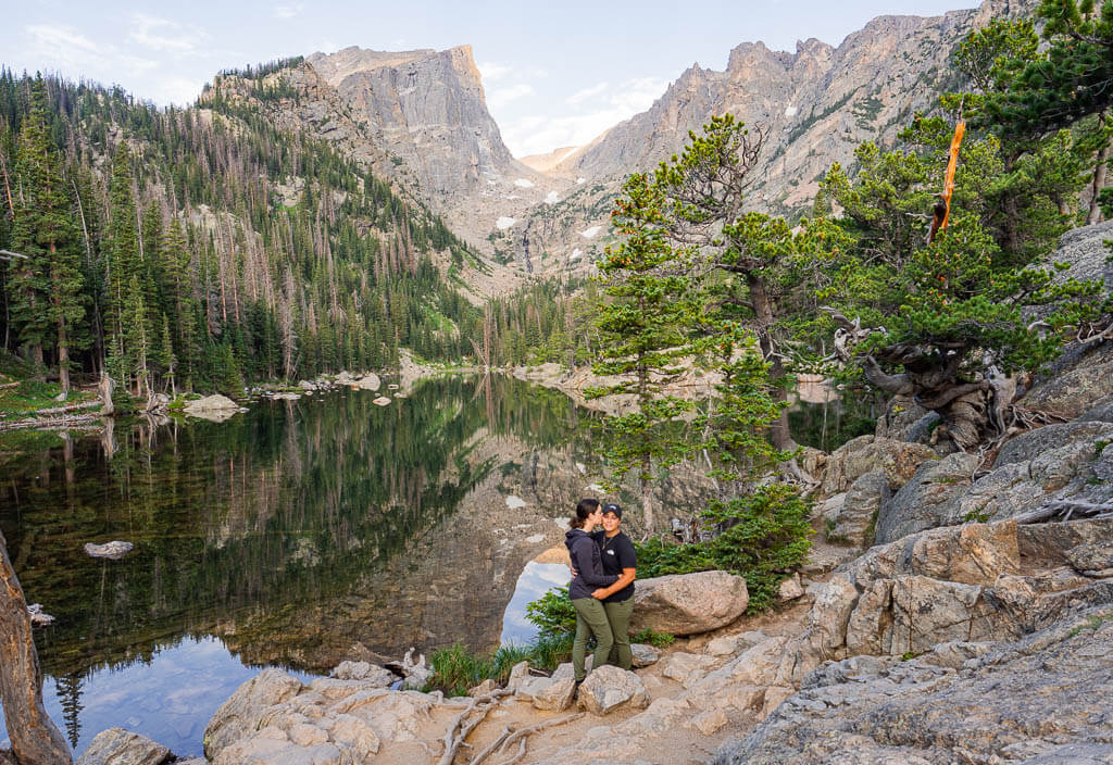
Location: Colorado
Suggested Stay: 3-4 days
Entrance Fee: $30 per vehicle (valid for 1 day) or $35 per vehicle (valid for 7 days)
Highlights: Alpine lakes, Trail Ridge Road, wildlife, Estes Park, Continental Divide
Fun Fact: Rocky Mountain National Park’s Alpine Visitor Center is at the highest elevation of all National Park sites in the United States.
Closest Airport: Denver International Airport (DEN)
Rocky Mountain National Park Official Website
Rocky Mountain National Park is home to some of the most beautiful stretches of wilderness we have ever seen. It offers hands done the best alpine scenery in the United States with its breathtaking lakes and mountains.
Here, you will get to experience the highest elevations in the west with mountain peaks over 12,000 feet. This is one of the west coast national parks you won’t want to miss.
Best Things to Do
- Drive Trail Ridge Road – Trail Ridge Road is the highest continuous paved road in the USA, reaching 12,183 feet. The road runs for 48 miles from Estes Park to Grand Lake.
- Visit the Alpine Lakes – Rocky Mountains National Park has more than 150 subalpine and alpine lakes. A lot of them are easily accessible on a day or multi-day hike.
To see 6 lakes and 1 waterfall in 1 hike, visit the Bear Lake area of the park and combine various trails into a strenuous 9-mile loop. These are the lakes and waterfalls you will be able to see:
- Bear Lake
- Nymph Lake
- Dream Lake
- Emerald Lake
- Lake Haiyaha
- Mills Lake
- Alberta Falls
- Spot wildlife – Visit Moraine Park if you are interested in spotting wildlife. If you are lucky, you can see moose, bears, bighorn sheep, elk, deer, pikas, marmots, and various birds. Hike the easy 5.5 miles loop in the early morning or around sunset to increase your chances of seeing animals.
- Explore the different areas of the park. Getting to different areas of the park requires some driving but it is absolutely worth it. Hike the moderate 8.5 miles Calypso Cascades & Ouzel Falls trail to explore the Wild Basin area of the Rocky Mountains or the moderate 3.1 miles Gem Lake Trail close to Estes Park.
- Visit Estes Park – Visit the quaint Estes Park just outside of the Rocky Mountain National Park for some delicious food, and great shopping options. You can also book tours for various activities. A can’t miss attraction is the Stanley Hotel, the location which was the inspiration for Stephen King’s novel ‘The Shining’. If you dare, book a ghost tour to encounter some paranormal activities in this historical place.
What to Know Before Visiting Rocky Mountain National Park
- Get a timed entry ticket. The park system has implemented a timed entry permit for visitors from late May to early October to limit crowds during the high season. There are two different options: You can get an entry ticket for the park + the Bear Lake Road corridor, or just for the park but then you won’t be allowed to enter the Bear Lake area.
- The Bear Lake area is very busy. To visit the Bear Lake corridor, you either have to get there very early to snag a parking spot or you can use the park’s Hiker Shuttle. It provides a direct connection from Estes Park Visitor Center to the Bear Lake area. One great advantage of utilizing the shuttle is that you will be able to create your own loop hike by starting at one trailhead and exiting at another.
- Road conditions change quickly. Due to rough weather conditions, the roads in Rocky Mountain National Park may close at any time. Follow @RockyNPS on Twitter for updates on the latest road status.
Rocky Mountain National Park Suggested Itinerary
DAY 1: Drive Trail Ridge Road from west to east and stop at viewpoints and highlights along the way, hike the Calypso Cascade and Ouzel Falls trail in the Wild Basin area, and enjoy a sunset and wildlife at Moraine Park.
DAY 2: Explore the Bear Lake area: combine trails to see Bear Lake, Nymph Lake, Dream Lake, Emerald Lake, Lake Haiyaha, Mills Lake, and Alberta Falls.
DAY 3: Hike to Gem Lake, explore Estes Park and tour The Stanley Hotel.
When to Visit
You should plan to visit Rocky Mountain National Park in the summer and early fall. During these times of the year, you will be able to have a full experience of the park since Trail Ridge Road will be open for travelers.
Although the crowds will be high, the weather is perfect for outdoor activities and the days are long.
Where to Stay
Camping – Moraine Park (NPS) → There are 4 more developed campgrounds in Rocky Mountain National Park
Budget – Ponderosa Lodge
Midrange – Inn on Fall River & Fall River Cabins
Great Sand Dunes National Park
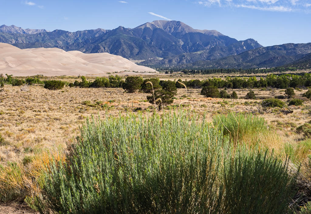
Location: Colorado
Suggested Stay: 1-2 days
Entrance Fee: $25 per vehicle (valid for 7 days)
Highlights: The Dunes, sledding, dark sky
Fun Fact: Is home to the tallest dune in North America.
Closest Airport: Colorado Springs Airport (COS), Denver International Airport (DEN)
Great Sand Dunes National Park Official Website
Great Sand Dunes National Park is truly a one-of-a-kind park. It is best known for being home to the tallest sand dune in North America, but the park also is made up of grasslands, wetlands, forests, and tundra.
When heading to this park, get your legs ready because it is a challenging climb up the dunes as the sand is sliding and shifting beneath your feet.
Best Things to Do
- Camp in the Dunes – One of the best experiences in the park is to spend the night in the dunes. A permit is required for backcountry camping in the dunes.
- Go Dune Sledding – Rent sandboards and slide down the dunes.
- Watch the Stars – The night sky is the best for watching the stars, gazing at the milky way, and wishing on a shooting star.
- Hike to the top of the Tallest Dune – Star Dune is the tallest dune in North America at 750 feet.
- Zapata Falls – Visit nearby Zapata Falls just outside the park. The road is extremely rough and bumpy and requires a 4×4 vehicle with high clearance.
What to Know Before Visiting Great Sand Dunes National Park
- Be prepared for a windy environment. When the wind is blowing, the sand is whipping and can hurt. Our face coverings were true lifesavers when we were hiking the dunes.
- Purchase a backcountry dunes permit. If you want to experience the one of a kind sleeping under the stars in the dunes, reserve your tickets in advance on recreation.gov. There is only a certain amount given out daily.
- Protect yourself from the sun. During certain times of the year, it gets really hot in the Great Sand Dunes National Park. Bring enough sunscreen and wear a hat, sunglasses and a shirt which offers UV protection.
Great Sand Dunes National Park Suggested Itinerary
DAY 1: Go dune sledding, hike to High Dune and Star Dune, and backcountry camp in the dunes.
DAY 2: Explore lesser-known areas of the park, and check out Zapata Falls.
When to Visit
The ideal time to visit Great Sand Dunes National Park is in the spring and fall because the temperature is just right.
Visiting in the summer heat can bring the sand temperatures to well over 100 degrees Fahrenheit during the midday sun. We would not recommend being out on the dunes when temperatures are that high.
Where to Stay
Camping – Piñon Flats Campground (NPS)
Budget – Oasis Duplex Motel
Midrange – Great Sand Dunes Lodge
Grand Canyon National Park
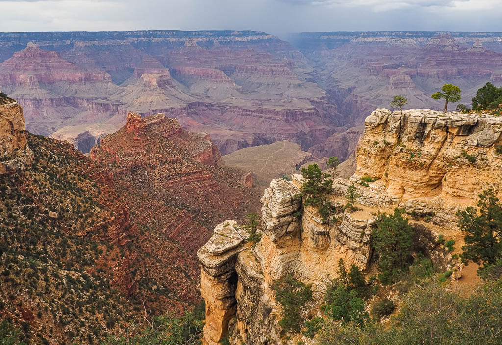
Location: Arizona
Suggested Stay: 1-3 days
Entrance Fee: $35 per vehicle (valid for 7 days)
Highlights: Grand Canyon Skywalk, Grand Canyon Rim Trail, South Rim, North Rim
Fun Fact: The Grand Canyon is bigger than the entire state of Rhode Island.
Closest Airport: Flagstaff/Pulliam Airport (FLG), Phoenix Sky Harbor Airport (PHX), Las Vegas McCarran International Airport (LAS)
Grand Canyon National Park Official Website
The Grand Canyon is one of the most notable and well-known National Parks in the west. The park is best known for the massive 277 miles long and 18 miles wide canyon. It is one of the most famous landmarks in North America and one of the 7 natural wonders of the world.
You can experience the iconic canyon in many different ways. See the astonishing landscape from a bird’s eye view or hike down to the base of the canyon to get a close-up vista. One thing is for sure, a visit to the Grand Canyon National Park is a must on your west coast national parks journey.
Best Things to Do
- Hike the Trails
- South Kaibab Trail to Cedar Ridge (2.8 miles, easy)
- Grand Canyon Rim: Mules to Mather Point (6 miles, easy)
- Grand Canyon Rim Trail (12.7 miles, easy)
- Bright Angel Trail (15.3 miles, strenuous)
- South to North Kaibab Trail (19.3 miles, strenuous)
- Grand Canyon Skywalk – Walk the 10-foot wide horseshoe-shaped glass-bottom pathway out 70 feet over the Grand Canyon. Peek down for a clear view of 4,000 feet into the canyon. Don’t forget to purchase your ticket.
- Helicopter ride over the Canyon – Get a unique perspective of the Grand Canyon from high above as you soar around in a helicopter.
- Tour the Desert View Drive. Start at the Grand Canyon Village and drive the 23 miles to the East Entrance of Grand Canyon National Park. On your way, stop at the 6 stunning viewpoints and the Tusayan Museum and ruin site to learn more about the historic Ancestral Puebloan village.
- Catch a sunrise or sunset – See an uncommon sunrise or sunset over the Grand Canyon as the sky is illuminated in an array of colors. Pretty much all the viewpoints along the South Rim are great for watching the sun setting down.
- Grand Canyon Village – Walk around the historic Grand Canyon Village and visit the sites, like the ancestral Hopi House, the Grand Canyon Railway Depot, and the Buckey O’Neill cabin.
What to Know Before Visiting Grand Canyon National Park
- Weather can change rapidly. The Grand Canyon National Park has its own microclimate. Due to the different altitudes, the canyon experiences some intense weather conditions. Always be prepared for a thunderstorm. Also, the summer months can get very hot and most of the trails are unshaded. Prepare yourself with proper clothing and sunscreen.
- Utilize the free shuttle service. To get to the various viewpoints and trailheads, simply take one of the shuttle buses which run every 15-30 minutes. The park currently offers four different routes. Plan some extra time, since waiting lines can get quite long in the busier months.
- The Grand Canyon Skywalk is far away. The Grand Canyon Skywalk is located at the West Entrance Station. From there, it is a 4 hour’s drive to the most popular section, the South Rim, of the Grand Canyon National Park.
Grand Canyon National Park Suggested Itinerary
DAY 1: Visit the Grand Canyon Skywalk, drive to Grand Canyon Village and explore it.
DAY 2: Hike the Grand Canyon Rim Trail, take the shuttle to various viewpoints, and watch the sunset.
DAY 3: Tour the Desert View Drive, and hike the Bright Angels Trail or South Kaibab Trail.
When to Visit
Grand Canyon National Park is open all year round but comes with some challenges in the winter and summer.
In case you want to plan a trip to Grand Canyon National Park in the winter, be prepared for icy conditions. Heavy winter storms bring ice and snow. If you don’t mind the colder temperatures, you can get rewarded with quiet trails and magical snowy landscapes.
The summer can be extremely hot and busy which means crowded shuttle buses and less solitude.
Where to Stay
Camping – Mather Campground (NPS) → There are 2 other developed campgrounds in Grand Canyon National Park.
Budget – Bright Angel Lodge
Midrange – Yavapai Lodge
Suggested West Coast National Parks Road Trip Itineraries
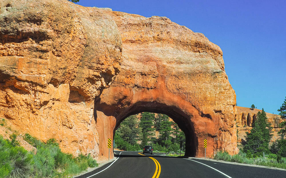
Here are our suggested routes to visit the national parks on west coast. Use these west coast national parks road trip route ideas as a starting point to planning your perfect getaway.
Road Trip West Coast National Parks Route: Down the Coast
This west coast national parks road trip down the coast from Washington to California includes all the west coast national parks which are actually located on the west coast.
Hike some of the highest mountains in the USA and cool down in some alpine lakes, learn more about volcanoes, explore the unique fauna and flora by seeing Joshua Trees and Sequoia Cacti, and visit the lowest point in the USA Badwater Basin in Death Valley National Park.
- North Cascades National Park: 2 days
- Olympic National Park: 3 days
- Mount Rainier National Park: 3 days
- Crater Lake National Park: 1-3 days
- Redwood National Park: 2-3 days
- Lassen Volcanic National Park: 1-3 days
- Pinnacles National Park: 2 days
- Yosemite National Park: 3-4 days
- Kings Canyon National Park: 2 days
- Sequoia National Park: 2 days
- Death Valley National Park: 1-2 days
- Joshua Tree National Park: 1-2 days
- Channel Islands National Park: 1-3 days
Time Needed: 30 – 40 days
Road Trip West Coast National Parks Route: The Alaskan Route
Are you ready for the greatest wilderness adventure of your life? Then plan a west coast national parks road trip to all of Alaska’s national parks for outstanding landscapes, including massive glaciers, majestic waterfalls, crystal clear lakes, and snow-capped mountain ranges.
The west coast national parks of Alaska are also one of the best destinations in the USA for watching wildlife. Spot bears feeding on salmon, moose, and elks roaming around in the tundra, and marine animals, like otters, seals, and whales, playing in the waters.
Note: We listed Glacier Bay National Park as an add-on because it is far away from the other parks in Alaska. A good option to include it to your west coast national parks road trip itinerary would be by having a stopover in Juneau on your flight back to one of the lower 48 states of the USA.
- Kenai Fjords National Park: 2-3 days
- Lake Clark National Park and Preserve: 4-5 days
- Katmai National Park and Preserve: 3 days
- Denali National Park and Preserve: 3 days
- Kobuk Valley National Park: 1-5 days
- Gates of the Arctic National Park and Preserve: 1-5 days
- Wrangell St. Elias National Park and Preserve: 3 days
- Add-On: Glacier Bay National Park and Preserve: 3 days
Time Needed: 22 – 30 days
Road Trip West Coast National Parks Route: Utah National Park Road Trip
For those who would love to visit a lot of U.S. National Parks of the west but don’t have unlimited time, we would recommend this adventure. Utah’s Mighty 5 National Parks can be easily combined into an unforgettable 1 to 2-week west coast national parks road trip.
Experience out-of-this-world vistas of curving canyons, natural arches, uniquely shaped rock formations, spires and buttes, and impressive mountain ranges.
Note: This road trip can be done in reverse order depending on if you start in Las Vegas, Nevada, or Salt Lake City, Utah. You can also change the order of Arches National Park and Canyonlands National Park since they are right next to each other.
- Zion National Park: 2-6 days
- Bryce Canyon National Park: 1-3 days
- Capitol Reef National Park: 2-3 days
- Arches National Park: 1-2 days
- Canyonlands National Park: 1-2 days
Time Needed: 8 -17 days
Road Trip West Coast National Parks Route: Hawaiian and American Samoa Loop
The west coast national parks in Hawaii are simply out of this world. Besides the fascinating volcanic landscape featuring massive craters, lava tubes, and natural arches formed by lava, you can explore the lush forests and catch some gorgeous waterfalls.
At Hawai’i Volcanoes National Park you might even be able to witness an active lava flow since one of the volcanoes on the island recently started erupting again.
If you want to visit the secluded paradise of American Samoa, you can extend your west coast national parks adventure easily. Hawaii offers some of the rare direct flights to Pago Pago airport.
- Haleakala National Park: 2 days
- Hawai’i Volcanoes National Park: 2 days
- National Park of American Samoa: 4 days
Time Needed: At least 9 days + travel time
Road Trip West Coast National Parks Route: Northern Western States
It would be a sin to visit one of these west coast national parks without exploring the other one!
Check out the first U.S. National Park and enjoy unique geothermal features like geysers, mud pots, and hot springs, before driving over to its lesser-visited neighbor Grand Teton where turquoise alpine lakes and dramatic mountain ranges are waiting for you.
- Grand Teton National Park: 3 days
- Yellowstone National Park: 4 days
Time Needed: 7 days
Road Trip West Coast National Parks Route: Southern Western States
This extensive west coast national parks road trip route includes all of the 10 national parks which are not directly located on the west coast but in one of the western states PLUS even more stunning western national parks in that area.
This route offers a great variety of landscapes. You can admire one of the best alpine sceneries in the USA, twisting canyons, and beautiful natural sandstone formations.
- Rocky Mountain National Park: 3-4 days
- Black Canyon of the Gunnison National Park: 2 days
- Arches National Park: 1-2 days
- Canyonlands National Park: 1-2 days
- Capitol Reef National Park: 2-3 days
- Bryce Canyon National Park: 1-3 days
- Zion National Park: 2-6 days
- Great Basin National Park: 2 days
- Grand Canyon National Park: 1-3 days
- Petrified Forest National Park: 1 day
- Saguaro National Park: 2 days
- Carlsbad Caverns National Park: 2 days
- White Sands National Park: 1 day
- Mesa Verde National Park: 2 days
- Great Sand Dunes National Park and Preserve: 1-2 days
Time Needed: 32 – 45 days
Additional West Coast National Parks Service Sites
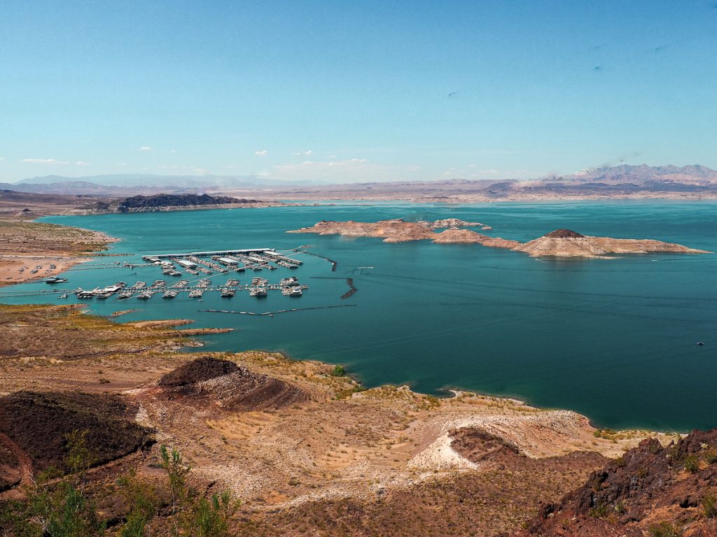
The National Park Service has more to offer than just the designated west coast national parks we talked about earlier. The USA includes a total of 423 National Park sites located in every state.
Top Tip: Wondering what the difference between a National Park and a National historic site is? National Parks cover a greater area and are more complex than historic sites.
On your national parks on west coast trip, make sure to also hit some of our favorite historic sites listed below:
- John Muir National Historic Site – California
- Muir Woods National Monument – California
- Cabrillo National Monument – California
- Golden Gate National Recreation Area – California
- Point Reyes National Seashore – California
- Pearl Harbor National Memorial – Hawaii
- Cedar Breaks National Monument – Utah
- Timpanogos Cave National Monument – Utah
- Grand Staircase Escalante National Monument – Utah
- Glen Canyon National Recreation Area – Arizona and Utah
- Lake Mead National Recreation Area – Arizona and Nevada
- Vermilion Cliffs National Monument – Arizona
- Sunset Crater Volcano National Monument – Arizona
- Wupatki National Monument – Arizona
- Devils Tower National Monument – Wyoming
- Craters of the Moon National Preserve – Idaho
West Coast National Parks Alternatives
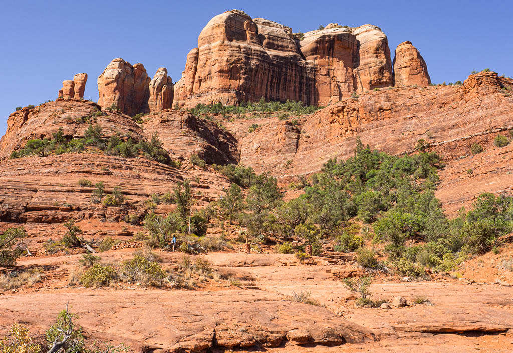
Who says that national parks on the west coast have to be more stunning and scenic than other landmarks in that area? We actually saw a lot of landmarks that were more mind-blowing than some of the west coast national parks we visited.
Judge yourself and add some of these landmarks to your national parks on west coast itinerary.
- Horseshoe Bend – Arizona
- Antelope Canyon – Arizona
- Havasu Falls – Arizona
- Sedona – Arizona
- Monument Valley – Arizona/Utah
- Kanarra Falls – Utah
- Hanging Lake – Colorado
- Valley of the Fire State Park – Nevada
- Hoover Dam – Nevada, Arizona
- Four Corners Monument – AZ, UT, CO, NM
- Big Sur – California
- Lake Tahoe – California
How many west coast national parks have you visited?
Share your most special west coast national park memory with us!
Our Other Resources for National Parks:
- 16 Best East Coast National Parks You Need to Visit
- First-Hand Ranking of National Parks in the U.S. from Best to Worst
- A Complete National Park List by State + Downloadable Checklist and Map
- How to Save Money with the America the Beautiful Pass
You Might Also Like:
- What You Should be Packing for a Hike: The Essentials + Extras
- 100+ Best Gifts for Hikers to Buy
- 50 Best Gifts for Outdoorsy Women Created by Outdoor Lovers
- 45 Useful Gifts for Road Trips You Didn’t Know You Needed
- 15 Most Helpful Hiking Apps to Download In 2022
- 31 Best Games for Road Trips for Adults to Beat the Boredom
- 100+ Tested Road Trip Pack List Essentials You Will Not Want to Forget
- 100+ Best Hiking Quotes to Inspire Your Future Adventures
- 19 Can’t-Miss Hikes in Sedona
- How to Secure a Permit for Havasu Falls
Save this Post for later on Pinterest!
Did you like this post? Subscribe to our newsletter and we’ll send you more unique travel tips, updates, and even FREE content!